Back to Home
Page of CD3WD Project or Back to list of CD3WD Publications
 |  |  | Roadside Bio-Engineering - Site Handbook (DFID, 1999, 160 p.) | |  | (introduction...) | | | Acknowledgements | | | Introduction | | | Safety Code of Practice for Working on Slopes | |  | Section One - Stabilising slopes with civil and bio-engineering | | | Section Two - Civil engineering techniques | | | Section Three - Bio-engineering techniques | | | Sector Four - Production of bio-engineering plants | | | Section Five - Maintenance of bio-engineering |  | | Annex A - Site assessment pro forma | | | Annex B - Full lists of species for bio-engineering in the road sector | | | Annex C - Nursery registers | | | Glossary | | | Back cover |
|
Annex A - Site assessment pro forma
Complete one pro forma per site. Use additional forms if there
are more than three segments on the site
|
Site location and chainage: |
|
|
|
|
Date of assessment: |
Assessor's name: |
|
|
|
Sketch of site |
|
|
[Label segments] |
|
|
|
|
|
|
|
|
|
|
|
|
|
Scale: |
|
Orientation: |
|
|
Segment number |
(1) |
(2) |
(3) |
|
(a) Erosion and failure processes |
|
|
|
|
(b) Other factors |
|
|
|
|
(c) Slope angle(s) |
|
|
|
|
(d) Slope length |
|
|
|
|
(e) Material drainage |
|
|
|
|
(f) Segment moisture |
|
|
|
|
(g) Altitude |
|
|
|
Assessment criteria. See Roadside Bio-engineering Site
Handbook, Annex A, pages 127-129 for details
|
(a) |
Erosion and failure processes. |
List the erosion or failure processes. State their size and
severity. |
|
(b) |
Other factors. |
List any physical factors that might affect the site. State
their size and severity. |
|
(c) |
Slope angle(s). |
Measure and place in one of 3 classes: <30°, 30 -
45°, or >45°. |
|
(d) |
Slope length. |
Measure and place in one of 2 classes: <15 metres or >15
metres. |
|
(e) |
Material drainage. |
Assess and place in one of 2 classes: good or poor. |
|
(f) |
Segment moisture. |
Assess and place in one of 4 classes: wet, moist, dry or very
dry. |
|
(g) |
Altitude. |
Determine: ± 100 metres. Use an altimeter, map or site
drawing. |
Figure A1: The main erosion and failure processes
|
MECHANISM |
DESCRIPTION |
|
Erosion on the surface |
Rills and small gullies form in weak, unprotected surfaces.
Erosion should also be expected on bare or freshly prepared slopes. |
|
Gully erosion |
Gullies that are established in the slope continue to develop
and grow bigger. Large gullies often have small landslides along the sides.
|
|
Planar sliding
(translational landslide or debris
slide) |
Mass slope failure on a shallow slip plane parallel to the
surface. This is the most common type of landslide, slip or debris fall. The
plane of failure is usually visible but may not be straight, depending on site
conditions. It may occur on any scale. |
|
Shear failure
(rotational landslide) |
Mass slope failure on a deep, curved slip plane. Many small,
deep landslides are the result of this process. Large areas of subsidence may
also be due to these. |
|
Slumping or flow of material when very wet |
Slumping or flow where material is poorly drained or has low
cohesion between particles and liquefaction is reached. These sometimes appear
afterwards like planar slides, but are due to flow rather than sliding. The
resulting debris normally has a rounded profile. |
|
Debris fall or collapse |
Collapse due to failure of the supporting material. This
normally takes the form of a rock fall where a weaker band of material has
eroded to undermine a harder band above. These are very common in mixed Churia
strata. |
|
Debris flow |
In gullies and small, steep river channels (bed gradient usually
more than 15°), debris flows can occur following intensive rain storms.
This takes the form of a rapid but viscous flow of liquefied mud and debris.
|
(a) Erosion and failure processes
A number of erosion and failure processes are to be found. The
types of erosion and slope failure found in Nepal are given in Figure A1. All
sites have a combination of these mechanisms at work on them. During site
assessment, you should check for these.
Figure A2: The main physical factors affecting slopes
|
POTENTIAL FACTOR |
DESCRIPTION |
|
Fault lines |
Small fault lines may cause differential erosion in parts of the
site. |
|
Springs |
There may be seasonal springs within the site, which cause
localised problems of drainage or slumping. |
|
Slip planes |
The main plane of failure may not be the only one. Many sites
have secondary, smaller slip planes additional to the main failure mechanism
|
|
Large gullies |
Large gullies nearby may erode backwards and damage the site.
Alternatively, they may discharge on to the site, causing deposition there.
|
|
Landslides |
Nearby landslides may extend headwards or sideways, or may
supply debris on to the site. |
|
River flooding |
A large river below the site may flood badly, damaging the site
by either erosion or deposition, or a combination of both. |
|
River cutting |
Rivers below the site may move in floods, undercutting the toe
of the site. |
|
Catchments |
If there is an extended catchment area above the site, it could
lead to a large discharge, which causes bad damage by erosion or deposition.
|
|
Drain discharge |
The discharge of drainage water must be safeguarded to avoid
causing erosion or mass failures. Poorly sited or inadequately protected
discharge points can cause severe problems. |
|
Khet and kulos |
Khet (rice paddy) land or a kulo (irrigation leat) above a site
usually means a large volume of water infiltrating into the slope, with a
greater potential for failure or large-scale erosion. |
|
Construction activities |
Construction activities on or near the site may lead to
undermining through excavations, or surcharging through spoil disposal in the
wrong places. |
(b) Other factors
In addition to erosion and failure mechanisms, other factors may
affect the site. Some are internal (e.g. springs) while others are external
(e.g. river undercutting). During site assessment, you must check for signs of
any of the potential damaging factors listed in Figure A2.
(c) Slope angle(s)
Measure the average slope angle of the slope segment and place
it in one of three classes:
< 30º,
30 - 45°, or
>
45°.
If there is more than one dominant slope, record all main slope
angles.
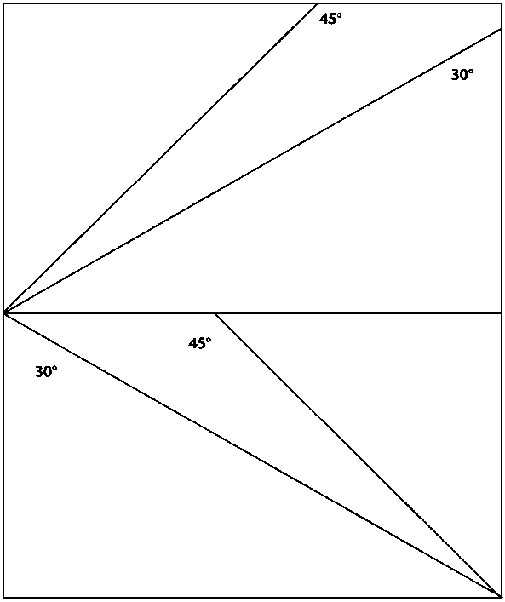
Figure
(d) Slope length
Measure the average length of the slope segment and place it in
one of two classes:
< 15 metres or
> 15 metres.
Figure A3: Common features indicating soil drainage
characteristics
|
MATERIAL DRAINAGE
CHARACTERISTICS |
TENDENCY TOWARDS GOOD DRAINAGE |
TENDENCY TOWARDS POOR DRAINAGE |
|
Overall drainage |
Freely draining material; dries quickly after rain storms |
Slowly draining material; tends to remain wet for long periods
after rain; behaves like firm dahi |
|
Soil particle size |
Coarse textures; loams and sandy soils |
Fine textures; clays and silts |
|
Porosity |
Large inter-connecting pores |
Small pores |
|
Material types |
Stony colluvial debris; fragmented rock; sandy and gravelly
river deposits |
Residual soils of fine texture; debris from mud flows, slumps,
etc. rato mato |
|
Slope types |
Fill slopes; cut slopes in stony debris (colluvium) |
Cut slopes in original consolidated ground |
(e) Material drainage
Assess and place in one of two classes: good or poor (see Figure
A3).
Figure A4: Environmental factors determining site
moisture
|
SITE MOISTURE FACTOR |
TENDENCY TOWARDS DAMP SITES |
TENDENCY TOWARDS DRY SITES |
|
Aspect |
Facing N, NW, NE and E |
Facing S, SW, SE and W |
|
Altitude |
Above 1500 metres; particularly above 1800 metres |
Below 1500 metres; deep river valleys surrounded by ridges |
|
Topographical location |
Gullies; lower slopes; moisture accumulation and seepage areas
|
Upper slopes; spurs and ridges; steep rocky slopes |
|
Regional rain effects |
Eastern Nepal in general; the southern flanks of the Annapurna
Himal |
Most of Mid Western and Far Western Nepal |
|
Rain shadow effect |
Sides of major ridges exposed to the monsoon rain-bearing wind
|
Deep inner valleys; slopes sheltered from the monsoon by higher
ridges to the south |
|
Stoniness and soil moisture holding capacity |
Few stones; deep loamy* and silty soils |
Materials with a high percentage volume of stones; sandy soils
and gravels |
|
Winds |
Sites not exposed to winds |
Large river valleys and the Terai |
|
Dominant vegetation |
e.g. utis, katus, chilaune, amliso, nigalo, bans, lali
gurans |
e.g. khayer, babiyo, khar, dhanyero, salla, imili,
kettuke |
* Loam is the name given to a soil with moderate
amounts of sand, silt and clay, and which is therefore intermediate in texture
and best for plant growth.
(f) Segment moisture
Assess and place in one of four classes:
|
Wet: |
permanently damp sites (e.g. north-facing gully sites).
|
|
Moist: |
sites that are reasonably well shaded or moist for some other
reason. |
|
Dry: |
generally dry sites. |
|
Very dry: |
sites that are very dry; these are usually quite hot as well
(e.g. south-facing cut slopes at low altitudes). |
See Figure A4.
(g) Altitude
Determine: ±100 metres. Use an altimeter, map or site
drawing.