Back to Home
Page of CD3WD Project or Back to list of CD3WD Publications
 |  |  | The Improvement of Tropical and Subtropical Rangelands (BOSTID) |  |  | Part II | |  | Introduction to the case studies | | | Pastoral regimes of Mauritania | | | (introduction...) | | | Physical geography | | | Migration cycle | | | The Beni Mguild of Morocco | | | (introduction...) | | | Physical geography | | | Migratory cycle | | | The Kel Tamasheq | | | (introduction...) | | | Introduction | | | Camp organization | | | References | | | Dromedary pastoralism in Africa and Arabia | | | (introduction...) | | | Introduction | | | Reproduction and risk | | | Management and labor | | | Subsistence production | | | Marketing | | | Predatory pastoralism | | | The future of camel pastoralism | | | References | | | The mountain nomads of Iran: Basseri and Bakhtiari | | | (introduction...) | | | The physical environment | | | The basseri | | | The bakhtiari | | | The Marri Baluch of Pakistan | | | (introduction...) | | | Physical environment | | | Seasons and migrations | | | A mixed economic system | | | Conclusiones | | | Changing patterns of resource use in the Bedthi-Aghanashini valleys of Karnataka state, India | | | (introduction...) | | | Introduction | | | The setting | | | Human communities | | | Traditional patterns of resource management | | | Colonial period | | | After independence | | | Recent trends | | | References | | | Kenya: Seeking remedies for desert encroachment | | | (introduction...) | | | Introduction | | | Background | | | Traditional pastoralism | | | Baseline studies | | | Vegetation and livestock | | | Directions for the future | | | The hema system in the Arabian peninsula | | | (introduction...) | | | Rights of ownership or use | | | The hema system in Saudi Arabia | | | The mahmia or marah, and the koze system in Syria | | | Neglect of the hema and its consequences | | | Hema in the range improvement and conservation programs in the near east | | | References | | | Wildlife land use at the Athi River, Kenya | | | (introduction...) | | | Background | | | Some early findings | | | Conclusion | | | Camel husbandry in Kenya: Increasing the productivity of ranchland | | | (introduction...) | | | Introduction | | | Location | | | Vegetation | | | Livestock | | | Introduction of camels | | | Management and adaptability | | | Reproduction and lactation | | | Veterinary notes | | | Economics | | | Reference | | | The potential of faidherbia albida for desertification control and increased productivity in Chad | | | (introduction...) | | | Background | | | Characteristics of faidherbia albida | | | Project description | | | Project analysis and evaluation | | | Conclusions | | | References | | | Improving Nigeria's animal feed resources: Pastoralists and scientists cooperate in fodder bank research |
|
The Improvement of Tropical and Subtropical Rangelands (BOSTID)
Part II
Introduction to the case studies
Successful efforts in rangeland improvement are dependent on a
thorough understanding of environmental context and the broad range of
interactive social, economic, and political factors that affect project
formulation and implementation. The most useful and socially responsible way to
achieve this understanding is through the analysis of indigenous social
adaptations to particular regions. The case studies in this book illustrate the
adaptations to various settings in Africa and Asia.
The adaptations described in several of these case studies
(specifically, 1, 2, 5, and 6) were characterized over 20 years ago and their
use here should not be taken to indicate that they continue to be reasonable
reflections of current local conditions. The evolution of range and pastureland
systems of resource management in response to stress has been discussed in a
companion study, Proceedings of the Conference on Common Property Resource
Management (National Academy Press, 1986).
The first case study, "Pastoral Regimes of Mauritania,"
contrasts the adaptations of the Rigaibat Lqacem of the Saharan zone with those
of the Ahel bou-Lobat and other groups associated with the Mauritanian Sahel.
Case study 2, "The Beni Mguild Arabs of Morocco," illustrates a complex system
of adaptations to a mountainous region dominated by winter precipitation. The
third case study, "The Kel Tamasheq of Mali," explores the material culture and
diet of the Oulliminden tribe of the Malian Sahel. Not only do these case
studies underscore the logic of indigenous adaptations, but provide insight into
the probable social and environmental consequences of inappropriately designed
rangeland improvement projects in the regions described.
With few exceptions, the livestock projects undertaken by
governments and international assistance agencies in tropical and subtropical
regions have focused on cattle. In the highly degraded rangelands of the drier
zones, however, other forms of livestock often enjoy a comparative advantage. In
recent years, renewed interest has been expressed in the camel. Case study 4,
"Dromedary Pastoralism in Africa and Asia," discusses camel husbandry and its
potential contributions to modern economies. Case study 5, "The Mountain Nomads
of Iran: Basseri and Bakhtiari," describes two largely sheepbased pastoral
systems seasonally adapted to the Zagros mountains and their associated
lowlands. Case study 6, "The Marri Baluch of Pakistan," describes a complex
livelihood system that incorporates herding, agriculture, gathering, and wage
labor. Case study 7, "Changing Patterns of Resource Use in the BedthiAghanashini
Valleys of Karnataka State, India," describes the dynamic interactions among
differing human communities, external forces, and the regional resource base in
the Uttara Kannada district of the Western Ghats.
Many contemporary efforts in rangeland improvement and regional
development are based in systematic environmental analysis and the
complementarily of Western science and traditional knowledge. Case study 8,
"Kenya: Seeking Remedies for Desert Encroachment," describes the approach taken
in UNESCO's Integrated Project in Arid Lands in northern Kenya. Other
contemporary efforts draw more heavily from the past. "The Hema System in the
Arabian Peninsula," case study 9, describes the successful reintroduction of one
of the world's oldest systems of rangeland management into the drylands of the
Middle East.
Case study 10, "Wildlife Land Use at Athi River, Kenya,"
explores the possibility that the most ecologically sound and economically
rewarding use of rangeland in many areas may be for wildlife ranching rather
than for conventional livestock projects. Case study 11, "Camel Husbandry in
Kenya: Increasing the Productivity of Ranchland," discusses the complementary
integration of camel and cattle husbandry on four ranches in Kenya. Both papers
reflect a trend toward greater innovation in land use. Case study 12, "The
Potential of Faidherbia albida for Desertification Control and Increased
Productivity in Chad," while focusing on the contributions of a single species,
discusses ways of better integrating agriculture and animal husbandry in the
African drylands. The final case study, "Improving Nigeria's Animal Feed
Resources: Pastoralists and Scientists Cooperate in Fodder Bank Research,"
describes a modern approach to the creation of fodder reserves that is
functionally similar to the ancient hema system described in the ninth case
study.
Pastoral regimes of Mauritania
DOUGLAS JOHNSON
Mauritania remains one of the few countries in the world in
which pastoral activities continue to play a prominent role for a large segment
of the population, despite some instances of sedentarization (1) and other
modifications of livelihood reflecting changing ecological, social, economic,
and political conditions. Because Mauritania covers a wide latitudinal range and
contains a variety of physiographic and climatic regions with generally arid
characteristics, it offers a range of marginal environments whose utilization
can only be accomplished by a pastoral nomadic life. Existing in precarious
balance with these marginal environments are several pastoral regimes that, in
their evolution, have arrived at a combination of pastoral and agricultural
activities in an attempt to best use the available resources. That the various
combinations of camel, goat, sheep, and cattle herding, together with date and
grain cultivation, have continued to function effectively for centuries is a
telling comment on their basic rationality and
efficiency.
Physical geography
Mauritania can be divided into two markedly different
physiographic and environmental zones. The southern Sahel, particularly along
the coast, is of low relief, with the coastal plain extending inland for 500 km
before encountering a line of cliffs. The coast is a barren one, (2) replete
with coastal dunes and depressions, such as the Aftout as-Sahali, while sand
dunes interspersed with barren regs, or stony surfaces, stretch deep into the
interior. Once away from the littoral zone, it is possible to find some grazing
areas despite the generally barren nature of both dunes and regs, but vegetation
is severely limited by scanty and often saline water resources. In the interior
of the country, occasional plateaus rise above the level of the surrounding
plains, and some of these, most notably the Adrar, contain important oases.
North and east of the Adrar are several northeast to southwest oriented bands of
sand dunes (extensions of Erg Chech and Erg Iguidi) that give way still farther
north to the reg deserts of Ghallamane and Yetti. (3) Occasional low massifs
(al-Hank, Zemmour Labyad), often with steep cliffs, as well as the Hamada of
Tindouf and Wadi Draa, add variety to an otherwise sterile and monotonous
landscape.
The southern and central regions of Mauritania are influenced by
a tropical climatic regime, the impact of which extends as far north as the
Tropic of Cancer to the northwest of the Adrar. But east of the Adrar, the 50-mm
isohyet that marks the northern boundary of the tropical influence dips below
the parallel of 18°N. (4) Rainfall totals increase rapidly south of this
line, and the 50-mm isohyet, marking the southern boundary of the Sahel, extends
westward from just north of Dakar across northern Senegal and along the southern
boundary of the Hawd. Although the exact onset of the rains is variable, most of
it falls during the summer months. The rainy season usually begins in May around
S�libabi and N�ma, and in July around Nouakchott, Boutilimit, and Tidjikja. As
the rains proceed northward, the variability in their occurrence from year to
year increases steadily (as, for example, the recording of 247 mm at Atar in
1927 followed by only 31 mm in 1928)5 and their inception is sometimes delayed
until as late as August in Tagant and the Hawd. These summer rains are part of
the Inter Tropical Convergence Zone, and their arrival is signaled by the
outburst of violent thunderstorms that also characterize the Kel Tamasheq
country farther to the east. Along the entire coast rainfall is light, but the
effects of the summer heat are somewhat modified by the influence of the cool
offshore current as well as by the frequent occurrence of fog and dew. In the
south, three major seasons can be recognized: a hot, humid summer from June
until the end of August, during which most of the year's precipitation occurs,
and a winter season that is subdivided into a cool, dry period and a hot, dry
period. (6)
Vegetation flourishes during the rainy summer season, is
adequate during the cool, dry season, and is thoroughly dried out during the
hot, dry period, when water - or, more accurately, lack of water - is the
crucial concern, and a decided concentration of all nomadic groups around
permanent sources of water is the rule. In the south, the vegetation is composed
of a savanna complex of various acacias (Acacia nilotica, A. senegal, A. flava,
and A. tortilis) with an understory of grasses and herbs, particularly cramcram
(Cenchrus biflorus). (7) To the north, in keeping with the declining rainfall
totals, the occurrence of acacias becomes less frequent, and the understory
diminishes to scattered clumps of had (Cornulaca monacantha) and sbat (Aristida
pungens). In the far north, acacias are restricted to the beds of wadis (usually
dry intermittent streams) or especially favored locations in the uplands where
they form a major part of the diet of camels; had, sbat, awaraj (Calligonum
comosum), and various halophytes form the preferred forage of camels and sheep.
North of the Adrar, the major climatic influence is derived from
the Atlantic, rather than from the tropics, and the regime is distinctly
Mediterranean in character. Unlike southern Mauritania, precipitation in the
north occurs at the very end of the summer and during the early months of
winter. (8) Although this rainfall may be locally heavy, totals throughout the
northern areas are small, and the distribution is usually sporadic and highly
localized. While permanent water supplies can almost always be located in wadi
beds and beneath sand dunes at no great distance from the surface, most of the
rocky expanses, hamadas and regs, are devoid of dependable water resources. Here
the winter rains are of crucial importance, for they cause a rich ephemeral
vegetation to spring up wherever they occur, while the rainpools that collect in
isolated hollows assure adequate water for man and beast during the winter
grazing season, thus permitting the exploitation of what would otherwise be
barren and unusable
areas.
Migration cycle
The Rigaibat Lqacem
The Rigaibat, the most powerful nomadic group in upper and
middle Mauritania, form the basis of this case study. They are a tribe of
remarkable solidarity, with a social structure that has attracted a great deal
of interest. (9) They are grouped into two major divisions, the Lqacem (or
eastern) and the Sahel (or western) Rigaibats. It is the pastoral pattern of the
former that will be discussed here. Despite the fact that some scholars have
contended that the pastoral activities of the Rigaibat take them everywhere in
the western Sahara in a patternless pursuit of rainclouds, (10) nothing could be
more at odds with the truth. Albeit somewhat less structured than the
regularized patterns of southern Mauritanian pastoralists, the Rigaibat regime
nevertheless involves regular, seasonal movements.
The areas occupied by the Rigaibat Lqacem are largely barren.
The reg of Yetti is nearly devoid of wells, a circumstance making its use
impossible except when winter rains cause the formation of rainpools. The same
conditions apply to the Hamada of Tindouf, although Erg Iguidi, which bisects
the Lqacem country, is surprisingly rich in wells. In contrast to the aridity of
the central regs and hamadas, the peripheries of the Lqacem area are more
elevated, and the wadis draining the slopes of al-Hank and Zemmour Labyad offer
better possibilities for locating water throughout the year. Because of the wide
expanses of land that are without vegetation during most of the year, a
similarly wide disperson of friqs (the basic herding unit of five or six tents)
is also common. This wide dispersion is apt to create an impression of
irregularity. Although individual sections within the Rigaibat tribe have
traditional areas of nomadization, in any one place in the Rigaibat territory,
at any one time, a number of friqs from various sections may be found as
individual tent groups follow their own best advantage. This pursuit of relative
advantage is not without regularity, however, even though unusually bad years
may force a departure from the normal regime and a concentration of friqs in the
Wadi Draa of Morocco or in the better watered portions of central and southern
Mauritania (11) - peripheral areas usually well beyond the normal zone of
Rigaibat Lqacem grazing.
In winter, the various Rigaibat groups can be found around
permanent watering points or shallow wells in Wadi al-Saquia al-Hamra, Wadi
al-Ma, and Wadi Chenachane, along the flanks of the Zemmour Labyad and al-Hank
ridges, or in especially favored hollows among the sand dunes of the Erg Iguidi.
(12) During the summer, the friqs are concentrated in the wadi bottoms of the
ergs, and the regs and hamadas are almost totally devoid of occupation. The
distribution of herds and friqs remains unchanged until the first rains begin.
Once there is a definite rainfall, scouts are sent out to
determine the precise part of the hamada in which the rainfall and resulting
vegetation are best. (13) A variety of different moves, or no moves at all, are
possible. If precipitation fails, the herder will move great distances to the
very borders, or beyond the borders, of the tribal territory. If rain is
especially abundant near the summer grazing areas or if the flock is composed of
animals incapable of withstanding the rigors of long-distance migration, the
nomad may not move at all. In general, however, assuming a year of average
rainfall, there is a movement from the summer grazing areas on the flanks of the
surrounding ridges into the hamadas and regs in the center. The precise area
selected for winter grazing may vary from year to year, but the overall pattern
of movement from summer wells to winter pasture in the interior desert remains
unchanged. The area selected depends on whether that zone has received
sufficient rainfall. (14) If so, friqs from different sections concentrate
around the favored area.
In 1959, the most favored areas were around the wells of
al-Haiaina and Bou Ameima. Nevertheless, not all friqs went to the summer
pastures in Yetti. A close check of the number of friqs present in the winter
wadis (as shown in figure 1-1) indicates that nearly half failed to leave their
winter locations. Admittedly, 1959 was a somewhat humid year, thus making local
resources more attractive and perhaps reducing the desirability of moving. Also,
the poor families, unwilling to face the potential risks involved in shifting
their flocks to relatively unfamiliar territory, perhaps remained behind, while
those possessing larger herds and greater ability to resist sudden catastrophe
risked the migration. This points out the variation in patterns of movement that
can be found within one tribe. The limited circulation of the poorer friqs
around permanent water supplies and along the course of the wadi beds resembles
the limited movement of the Kel Tamasheq.
The greater part of the winter is spent grazing the reg and
hamada pastures until the wells, pools, and vegetation dry out and a return to
the summer wells becomes imperative. During the stay at the winter pastures, the
pastoral regime is complicated by the fact that the Rigaibat Lqacem, except for
a few sections that are exclusively camel herders, own mixed herds of camels and
sheep that are herded separately during most of the year. (15) The tents of each
friq are pitched only a short distance apart and the milch camels, upon which
the herding unit depends for its basic subsistence, are allowed to graze freely,
under the care of the women, within a radius of three to six miles of the camp.
However, the baggage camels and surplus female camels are placed under the care
of the men and are herded separately from the milking herd; often these herds,
representing the reserve wealth of the friq, operate at great distances from the
family camp site. Most friqs also have a herd of sheep that is tended by the
older children at a short distance from the camp site, to which they return
twice each week to water the stock. It is quite common, therefore, for a
substantial number of people and animals to be away from the friq at any time,
thus conveying a false impression of small herds. This dispersal from and
circulation around the actual tent site is greatest during the winter months
when pastures are better and more widespread, but at all times the tent remains
the focus of the pastoral system, and periodic return trips are made to the friq
to water the stock. Thus, while the separate movements of the various herds
during winter and summer grazing complicate the pastoral regime, they in no way
detract from the essential regularity of the seasonal well-to-desert pattern of
movement.
FIGURE 1 -1 Rigaibat Lqacem of
northern Mauritania (after Bisson, 1963).
The Tribes of Southern Mauritania
In the broad stretch of territory extending from the Adrar to
the southern border of Mauritania are found a number of different types of
nomadic adjustments. Camels, sheep, goats, and cattle are all herded in this
zone. Some tribes specialize in one animal, but tribal herds more often contain
a variety of species, the exact mix depending upon complex balances among habit,
tradition, the role of agriculture in the tribe's economy, political power and
prestige, local variations in relief and climate, and other factors.
Camels are much more common in the arid north, where frequently
they are the only animal herded. Their frequency and importance declines the
nearer one comes to the more humid and disease-ridden regions along the Senegal
River. Cattle, being less mobile, more demanding in their water requirements,
and unable to utilize dune formations for forage, are found in greatest numbers
in the south, where their ability to live on dry forage during the summer months
makes them especially valuable. Sheep and goats are found everywhere, a function
of their intermediate position between camels and cattle, for they are more
mobile and more omniverous in their eating habits than cattle but less resistant
to drought conditions than are camels.
Thus, groups with a greater proportion of camels than other
animal species will cover longer distances in their annual migrations than will
those tribes whose herds are largely composed of cattle. Also, tribes herding
camels, sheep, goats, and cattle will, depending upon the size and importance of
the different herding components, split their herds in an attempt to realize the
optimal potential of each species.
In addition to these regularities in the areal distribution of
animals and of the pastoral regimes that result from them, there is a distinct
regularity in the latitudinal zones occupied by the Mauritanian nomads. During
the hot, dry season, the herds and their masters are always concentrated in the
southern portion of the Sahel zone, where numerous permanent wells supply water
needs; in the rainy summer season, the tribes move northward to exploit pastures
made green by the advancing tropical showers, and they usually remain somewhere
in the northern portion of their tribal territory during the cool, dry season.
(16)
The actual extent of northward penetration depends in part upon
the adequacy of the rains, while in especially dry years many tribes, including
the Rigaibat from the Saharan zone, can be found in the extreme southern part of
Mauritania, where grass and water supplies are more assured. Also, most tribes
have an association, either of reciprocity or domination, with an oasis or group
of oases where they can obtain supplies of dates and grain, and this means that
most tribes have a gatna (date harvest) period when they are back at the oasis
for the harvest. (17)
Finally, while theoretically the need to water stock adequately
is the only potential limitation upon migrations, in practice habit plays a
large role in determining where a tribe will graze. (18) It is the return year
after year to an area with well-known watering and grazing potentials that
permits the delineation of tribal territories, and only dire necessity will
force a tribe to move to an area outside its normal orbit.
In the most southerly parts of Mauritania, the fact that cattle
and sheep form the basic component of the herds, coupled with the importance of
cereal cultivation, keeps the extent and duration of pastoral movements small.
(19) When the rains begin, the herders commonly make a short movement southward
to pick up the rainfall at the earliest possible moment (20) and then follow the
advance of the rains northward. Once the rainy season is over, the tribes return
to their traditional summer wells, where they occupy a restricted area in close
proximity to the watering point. Although the return is usually completed by
October or November, some groups, for example the Ladem of the Hawd, (21) spend
the cool, dry season at some intermediate point in the tribal territory.
Further north, the mixture of pastoral and agricultural forms
becomes more complex. Some tribes are strictly camel herders, with little or no
interest in agriculture. For example, the Ahel Noh spend the cool, dry season in
the southern part of their area, the dry, hot season in an intermediate zone of
sand dunes, and the rainy season on the edge of the Dar in the north. (22) The
location of the dry, hotseason pastures in a zone intermediate between the
pastures of the other two seasons is quite unusual, but actually represents
merely an adaptation to peculiar locally favorable resources - in this case, the
water resources collected at shallow depths beneath the dunes.
Most tribes, however, possess mixed herds. Those tribes herding
sheep and camels divide the herds, with the sheep (and small herds of cattle, if
these are owned) moving in restricted orbits in close proximity to the permanent
watering points and agricultural centers of the section. Most of the family
remains with the sheep and cattle herds. However, the camels, accompanied by
shepherds and the young men, move in a completely different orbit and make use
of this animal's superior mobility to range far into the interior. Whereas the
herds of sheep follow a more fixed and definite route determined by the location
of permanent watering points, the camel herders range more widely, visiting
those places on their accustomed itinerary that have been especially favored by
the season's rainfall. Just how long this move into the interior lasts differs
from tribe to tribe.
Among the Ahel Saih Sidia, whose home wells are in the Awkar
region, the movement of camels into the Inchiri region near Akjoujt lasts only
during the rainy season; both the cool and hot dry seasons are spent in the
southern Awkar, although during the cool season the tribe drifts south toward
the wells, while at the end of the hot season they begin to move away from the
wells in anticipation of the rainy period. (23)
On the other hand, the Ahel bou-Lobat (24) spend the rainy
months moving slowly northward over relatively short distances, but once the
rains cease they range far to the north into the Adrar, utilizing the dry but
still nourishing pasture while the cool weather lasts. The Ahel bou-Lobat regime
is complicated by the fact that the tribe owns palm trees at the oases of
Dendane and at-Tiaiert and so must be present for the gatna season in July and
August. Thus, their yearly cycle includes hot, dryseason camel camps midway
between the two oases, a gatna move to the oases in July when all the herds are
grouped together, a slow movement northward during the rainy season, a long loop
into the Adrar in the cool season, and, finally, a southward return march to the
hot-season camp site.
The combination of agricultural and pastoral activities is more
complex among the Haiballah than in any other group. (25) Beginning with a gatna
stop at al-Fejha in the Tamourt an-Naaj wadi (along the east side of the tribal
territory), the Haiballah then move out onto the plateau during the rainy
season. As they proceed northward and westward during the cool, dry season, they
make stops at various agricultural areas to collect grain. Finally, as the hot
season approaches, they move south into the acacia forest of Tamourt an-Naaj,
where the leaves of the acacia trees form almost the sole pastoral resource
during the hot, dry months. Yet, despite the importance of agriculture in
determining where they are located at any time in the year, they remain
essentially pastoral.
Along the coast, there is little agricultural activity, but the
nomads participate in the general northward movement, parallel to the coast,
during the rainy season and often also during the cool, dry season, (26)
although some groups make a long move from Trarza deep into the Inchiri sand
dunes. (27) Once the hot, dry season begins, a rapid southward shift takes
place.
In conclusion, it seems significant that most of the nomads of
southern Mauritania move in a roughly eliptical pattern. Occasionally, their
outward and inward paths cross over each other, but it is more common for the
herds to return to the dry-season wells by a route different from the one
followed when leaving them. This difference in inbound and outbound routes is
not commented upon in any of the literature, but it may be that the exhaustion
of areas previously grazed during the year makes a selection of an alternative
route desirable.
NOTES
1. Charles Toupet. "Quelques aspects de la sedentarisation des
pomades en Mauritanie sah�lienne," Annales de Geographie LXXIII(400):738-745
(1964).
2. Peveril Meigs. Geography of Coastal Deserts (Arid Zone Research
No. 28, Paris: UNESCO, 1966), pp. 93-94.
3. For the physiography of northern
Mauritania, see Jean Bisson, "La nomadisation des Reguibat L'Gouacem," p. 214;
and Andre Cauneille, "Les pomades Regueibat," Travaux de l'Institut de
Recherches Sahariennes VI:83-84 (1950) .
4. Charles Toupet. "L'�volution de
la nomadisation en Mauritanie sah�lienne," in Nomades et nomadisme au Sahara
(Recherches sur la Zone Aride No. 19; Paris: UNESCO, 1963), p. 69.
5. Ibid.,
p. 69.
6. For the seasonal regime, see P. Borricand, "Le nomadisme en
Mauritanie," Travaux de l'lnstitut de Recherches Sahariennes, V:81-83
(1948).
7. Toupet, "L'�volution de la nomadisation en Mauritanie sah�lienne,"
pp. 69-70; and E. J. Paris, "Notes sur les puits de l'Azaouad (Soudan)," Notes
Africaine: Bulletin d'information et de correspondance de l'Institut Fran�ais
d'Afrique Noire, No. 53 (Janvier 1952), p. 24.
8. Cauneille, "Les pomades
Reguibat," p. 85; and Borricand, "Le nomadisme en Mauritanie," p. 86.
9.
David M. Hart, "The social structure of the Reguebat Bedouins of the western
Sahara," Middle East Journal XVI:515-527 (1962), makes much of this solidarity.
See also A. Leriche, Notes sur les classes sociales et sur quelques tribus de
Mauritanie," Bulletin de l'lnstitut Fran�ais d'Afrique Noire, S�rie B.
XVII:173-203 (1955); and Modat, "Aper�u sur la soci�t� Maure de l'Adrar,"
Bulletin du Comit� d'Etudes Historiques et Scientifiques de l'Afrique
Occidentale Fran�aise V:264-278 (1922).
10. See, for example, Hart, ibid., p.
516.
11. Andre Cauneille and Jean Dubief, "Les Reguibat Legouacem:
Chronologie et Nomadisme," Bulletin de l'lnstitut Fran�ais de l'Afrique Noire,
S�rie B. XVII (1955).
12. Jean Bisson, "Nomadisation chez les Reguibat
L'Gouacem," in Nomades et nomadisme au Sahara (Recherches sur la Zone Aride No.
19, Paris: UNESCO, 1963), p. 52, and map on p. 53; also idem, "La nomadisation
des Reguibat L'Gouacem," p. 215, and map on p. 214.
13. Bisson, ibid., p.
52.
14. Bisson's maps (ibid., pp. 53-54; and "La nomadisation des Reguibat
L'Gouacem," p. 214) point out the correlation between successive rainfalls in an
area and its choice as a pastoral zone. However, since 0a data only deals with
1959 - an admittedly humid year - there is no assurance that such overlap in
rainfall occurrence is an absolute prerequisite for an area's selection.
15.
Bisson, "Nomadisation chez lea Reguibat L'Gouacem," p. 53; and Borricand, "Le
nomadisme en Mauritanie," p. 89.
16. M. F. Bonnet-Dupeyron, Cartes de
l'Elevage en Mauritanie: D�placement saisonniers de. �leveurs en basse et
moyenne Mauritanie (Carte 1/500,000, en 2 feuilles: Ia-Ouest, et Ib-est; Paris:
ORSTOM, 1950). These maps are an often quoted source for the pastoral regime of
southern Mauritania, and they point out this pattern clearly. Although cluttered
and often confusing, they remain the most detailed work on the southern half of
the country. For other general statements on the regime, see Borricand, "Le
nomadisme en Mauritanie," pp. 86-87; and Toupet, "L'evolution de la nomadisation
en Mauritanie sah�lienne," pp. 69-70.
17. Ibid., p. 70; and Capot-Rey, "Le
nomadisme pastoral," Nomades et nomadisme au sahara (Recherches sur la Zone
Aride No. 19; Paris: UNESCO, 1963), pp. 72-73.
18. Borricand, "Le nomadisme
en Mauritania," p. 87.
19. See Paul Marty, Etudes sur l'Islam et les tribus
Maures: Les Brakna (Collection de la Revue du Monde Musulman; Paris: Ernest
Leroux, 1921) an example of these limited movements in the Brakna area.
20.
Capot-Rey, Le Sahara fran�ais, in L'Afrique blanche fran�aise Paris: Presses
Universitaires de France) II :2 59; and Borricand , "Le nomadisme en
Mauritanie," p. 86.
21. Toupet, "L'�volution de la nomadisation en Mauritanie
sah�lienne," p. 73.
22. Ibid., p. 71.
23. Paul Dubie, "La vie mat�rielle
des Maures," M�langes Ethnologiques (M�moires de l'Institut Fran�ais d'Afrique
Noire, No. 23; (Dakar: IFAN, 1953), pp. 122, 139.
24. Toupet, "L'�volution de
la nomadisation en Mauritanie sah�lienne," p. 72.
25. Ibid., pp.
74-75.
26. Bonnet-Dupeyron, Carte de ;'Elevage en Mauritanie
(Ia-Ouest).
27. Capot-Rey, La Sahara fran�ais, pp.
258-259.
The Beni Mguild of Morocco
DOUGLAS L. JOHNSON
Deciding just how nomadic or sedentary a particular tribal group
in rural Morocco is poses a major problem, for nearly every possible combination
of nomadism and agriculture can be found from group to group and often within
one group itself. Consider, for example, the At Atta on the Saharan side of the
Atlas, some of whose subgroups are fully nomadic, (1) while others are either
partially sedentary or are only partially nomadic. (2) It is also common for
sedentary agriculturalists to keep animals as a means of using otherwise
unexploitable areas and engaging in transhumant movements to bring these animals
to better seasonal pastures. (3) Indeed, as Blanche points out, (4) all
sedentaries keep some animals and all nomads do some supplementary farming, so
that "pure" nomadism hardly exists. It becomes quite difficult, therefore, to
determine what group is essentially nomadic unless primary weight is placed upon
the relative importance of the role played by animal husbandry and agriculture
within the tribal economy.
With this criterion in mind, it seems fair to say that the
subjects of this case study, the Beni Mguild of central Morocco, are essentially
a nomadic group. For while the pastoral-agricultural regime of the Beni Mguild
has frequently been described as a double transhumance (5) in which the
cultivation of cereal crops plays a large role, it is the necessity to shift
their herds of sheep and goats between various altitudinal zones at different
seasons of the year that gives the Beni Mguild Arabs their highly involved
migratory pattern.
This is not to deny the importance of agriculture, but the herds
are the primary source of wealth, and as such, claim priority in the system of
movement. This fact is amply demonstrated by the marked decline in the size of
all herds after the French penetrated the Moulouya Valley and restricted the
Beni Mguild's seasonal movements. (6) Precisely because agriculture is a
prominent part of their system and because they make so many moves in order to
exploit as fully as possible their rugged upland environment, the Beni Mguild
offer great insight into the adaptive nature of pastoral
nomadism.
Physical geography
The tribal areas of the Beni Mguild are located in the central
portion of the Middle Atlas and can be divided into three zones: (7) the Azaghar
Plateau region, the ridges of the Middle Atlas proper, and the steppes of the
Upper Moulouya Valley. The Middle Atlas range dominates the region. Aligned in a
southwesterly to northeasterly direction, the Middle Atlas is a broken,
mountainous area running from the High Atlas to an abrupt termination near Taza.
At its southern end, the range drops rapidly to the Plain of Tadla on its
western side, while it runs parallel to the High Atlas on its eastern side. It
is separated from the High Atlas by the deep gorge of the Wadi al-Abid. This
dividing line is more than simply a physical separation, for in the more arid
areas south of the High Atlas, the Ait Atta practice a form of nomadism that
differs notably from that of the Beni Mguild. (8) North of the Wadi al-Abid, the
Middle Atlas trends in a more westerly direction, and the wedge-shaped upper and
middle Moulouya plains intrude between the two ridges. Here, the eastern
boundary of the Middle Atlas is marked by an abrupt descent into the Moulouya
Valley. Boundaries for the Middle Atlas peaks, some of which exceed 2,500 m and
many of which are important summer grazing areas for the herds of the Beni
Mguild, are much less clear on all other sides, particularly to the northwest,
where the ground gradually drops off through plateau country as it slopes gently
toward the ocean.
This gently sloping upland is called the Azaghar Plateau. (9)
Bounded by an abrupt drop to the Sas Plain near Mekn�s on the north, the Plain
of Tadla and the fields along the Wadi Oum ar-Rbia on the southeast, and the
cliff of Zaiane on the west, the plateau has geographical unity despite its
gradual blend into the Middle Atlas. Averaging about 1,200 m in elevation, the
surface of the Azaghar Plateau is dotted by a series of old volcanic cones, is
cut by an intricate web of narrow valleys providing access to the area, and
contains a significant number of smaller plateaus that vary quite considerably
from the general elevation of the Azaghar. Both the Azaghar and the Middle Atlas
are drained by a number of streams and wadis, whose courses parallel the trend
of the mountains in their headwater portions, but later turn west to break
through the mountains on their way to the ocean, and in so doing open up routes
for passage through the mountains. It is this complex series of plateaus, old
volcanic cones, and narrow valleys that forms the winter grazing territory of
the Beni Mguild.
The third physiographic zone, the plain of the Upper Moulouya,
is a steppe region that contrasts markedly with the mountain and upland areas to
the west. Southeast of the town of Itzer, a very steep cliff emphasizes the
abrupt change in elevation between the Middle Atlas and the Moulouya steppe.
Here, a number of small streams tumble down out of the mountains, supporting the
small agricultural villages and fortified granaries that dot these valleys. (10)
West of Itzer, the slope from the Atlas into the plains is more gradual, and
agricultural possibilities are more limited.
As C�l�rier points out, (11) it is climate, acting upon the
physiography and the distribution of vegetation, that plays a key role in the
Beni Mguild's adjustment to and exploitation of their environment. As is the
case with much of the mountainous area of North Africa, Morocco is dominated by
the Mediterranean regime of summer drought and winter precipitation. The
eastward drift of cyclonic storms from the Atlantic encounters the barrier of
the Middle Atlas; being forced to rise, the storms deposit considerable
quantities of precipitation in the area. In the lowlands, this precipitation
falls as rain, but on the higher peaks (over 2,200 m) snow is the rule and the
snow cover here lasts all winter. The Azaghar Plateau, occupying an intermediate
position, receives rain and snow, but its elevation is sufficiently low that
snowfalls rarely result in significant accumulations. This winter snowfall is
crucial, because the quality of the summer pasture depends upon the adequacy of
the snowfalls (12) Although occasional violent thunderstorms bring some
precipitation to the uplands, pasture is dependent upon snow melt for its
nourishment. However, at the same time that snow is falling in the high Middle
Atlas and blocking all winter movement of man and beast across the mountains,
the absence of snow in the lower elevations is an essential prerequisite for the
successful winter pasture of the Beni Mguild in the Azaghar.
Vegetation shows a vertical zonation similar to the distribution
of rain and snow. (13) Cedar (Cedrus atlantica) is found on the higher slopes of
the more humid northern and central portions of the Middle Atlas. The
distribution of the cedar begins at about 1,300 m and extends upwards to the
snow line at about 2,200 m. However, above 2,200 m regeneration is difficult;
hence, an herbacious vegetation nourished by snow melt emerges in the spring.
Downslope from the cedars is the zone of evergreen oaks and occasionally of
thuya (Callitris articulata), which is frequently degraded by cutting, browsing,
and burning into a maquis assemblage. Numerous grasses and agricultural stubble,
important for foraging, are found below 2,000 m. On the eastern slopes of the
Middle Atlas, the entire character of the vegetation changes, for the rainshadow
effect of the mountains favors the development of a steppe complex, where
esparto (Stipa tenacisima) - a tough tussock grass, inedible during most of the
year - is most common.
The natural regime sketched above is one of distinct seasonal
and altitudinal variation in the availability of pasture and water. In summer,
agriculture engages the attention of tribesmen in lowland and plateau areas, and
the herds are kept in the upland areas over 2,200 m to take advantage of
pastures nourished by melting snow or the esparto of the Moulouya Valley. In
winter, herds are moved to the lowland plateaus of the Azaghar, where milder
temperatures and adequate rainfall permit abundant grazing on unoccupied land or
harvested fields. Actually, as indicated below, the system is still more
complex, for the Beni Mguild are engaged in cereal farming in the Moulouya
Valley at the same time that they are shifting their herds from zone to
zone.
Migratory cycle
The Beni Mguild are divided into two major groups, a northern
and a southern, and it is the migratory pattern of the southern group that is
considered here (figure 2-1). The southern Beni Mguild are, in turn, divided
into four separate subtribes, each with its own slightly different adjustments,
migratory routes, and areas of cultivation and pasturage. The northernmost of
these subtribes, the Ait Lias, begin their seasonal cycle south of Itzer, while
the larger Ait Ougadir (the Ait Quebel Lahram and Ait Ali) are strung out along
a series of small streams descending the steep eastern face of the Middle Atlas.
(14) The remaining two subtribes, the Ait Bougueman and the Ait Messaoud, are
spread out widely in the wedge-shaped portion of the Upper Moulouya on both
sides of the river and in the gorges of the ancient Massif of Aouli. (15)
October is taken as the starting point of the yearly cycle both
for convenience and because it marks the end of the Beni Mguild's agricultural
activities. (16) In October, the various Beni Mguild sections can be found in
the Upper Moulonya attending to their cultivated fields on the steppe. Once the
harvest is completed and stored in fortified granaries, it becomes necessary to
move to the Azaghar Plateau, as pasturage in the Upper Moulouya is insufficient
for all the flocks. This move to the Azaghar begins about the first of November
and continues throughout most of the month. Movement is slow and follows a
regular order from the southeast toward the northeast with one group of tents
packing up and leaving only to be followed immediately by another douar, or
village of tents, moving successively into the abandoned pasturage. (17) The
nomads always travel in substantial groups, or caravans, to prevent any
interference with their progress by other nomads or by sedentary villagers along
their route.
The Ait Lias go first, travelling through the pass at Tizi Zad
(on the main Mekn�s to Midelt road) to their traditional pastures around Azrou
and Ifrane, (18) although some have been reported as far west as al-Hajeb. (19)
Slightly later, the Ait Ougadir cross the first mountain barrier at Tizi-n
'Rechou and at a point somewhat farther north before turning northeastward up
the synclinal valley of the Wadi Serrou. After skirting Jabal Tamarakoit, Jabal
Hayane, and the slopes around Aguelmane-Azigza, they pass through Ain-Leuh on
the way to their winter pastures in the Plateau of Tellt between Wadi Beth and
Wadi Aguennor. (20) A similar route is also followed by the Ait Bougueman and
Ait Messaoud, who have long taken the same path as the Ait Ougadir. They also
winter on the Plateau of Tellt as well as in the plains of Messouar and Guertila
and on the Plateau of Ment. At one time, various sections of the Ait Bougueman
and the Ait Messaoud seem to have fallen under the authority of the Zaiane tribe
to their immediate south, thus permitting them to take slightly more southerly
routes to their traditional pastures, (21) but this evidently represented a
departure from the more normal pattern.
FIGURE 2-1 Arabs of the Middle Atlas
(after C�l�rier and Joly). (5)
Although the Azaghar is occupied by other nomadic groups during
the summer, these groups withdraw toward the coast during the winter and, except
for the agriculturists, the Azaghar is left to the Beni Mguild. (22) The Azaghar
is occupied throughout the winter months; the herds utilize the pastures made
rich and verdant by the winter rains. Once the snow is melted at the passes,
usually about the beginning of March, and movement back to the Moulonya Valley
becomes possible, the Beni Mguild leave the Azaghar. They retrace their steps,
following the same route in March as they did in November; this migration
usually takes an entire month.
By April, the Beni Mguild are back in the Moulonya Valley. Their
tents are dispersed along the edges of the irrigated fields and their animals
are pastured in the fields, thereby providing fertilizer for the next
agricultural cycle. (23) At the end of the month, the fields have been planted
and the Beni Mguild are ready to move once again. This time, the movement is
toward the high mountain pastures made available by the melting snow, for with
the steppe either planted in cereals or drying up, and with the Azagher occupied
by peasant agriculturalists or other nomads, only the upland pastures, over
2,200 m, remain to be exploited.
These mountain pastures are divided in the same way as the
lowland pastures, and each tribe knows what area is assigned to it and what
forest areas are open to its animals. (24) In the beginning of July, the herds
move out, crossing into Wadi Serrou and then turning north to Aguelmane-Azigza
and the slopes of Jabal Tamarakoit in a repetition of the initial stages of
their winter moves. (25) May and June are spent in carrying out this move with
the herds grazing slowly upslope through the forests, much to the chagrin of the
forest service. Only the Ait Messaoud fail to participate fully in this
movement. Driven from the Moulonya Valley by the desiccation of its pastures,
the Ait Messaoud, like the rest of the Beni Mguild, send many of their herds to
the northern slopes and plateaus of the High Atlas where, shaded from the full
impact of the sun's rays, adequate pasturage can be found. (26)
Not everyone follows the herds to the upland pastures, since
someone must stay behind to guard the family fields. The Beni Mguild possess
both large- and small-size tents, and it is the size of the tent accompanying
the herds, as opposed to the size of the tent remaining behind on the
agricultural fields, that indicates the relative importance of herding
activities. (27) Among the Ait Ougadir, the large tent goes with the herds into
the mountains, whereas the small tent remains behind near the agricultural
fields; the situation is reversed among the Ait Bougueman and the Ait Messaoud.
The herds and their keepers remain in the upland pastures through July and
August, albeit with occasional movement of individuals between the mountains and
the Moulonya Valley. In mid-September, (28) increasingly cool temperatures and
the need to harvest the cereal crop lead to a rapid movement of herds and
population back along the way they came, and hence into the upper Moulouya
Valley by October.
The system described above is complex. Although the distances
covered are not excessive (the distance from the upper Moulouya Valley to the
Azaghar is only about 100 km in a straight line, but of course is longer via the
nomads' route), they are extensive enough to make permanent housing impractical
for the majority of the population. In every instance, the direction of movement
is perpendicular to the mountain chain and utilizes streambeds and the passes
between them to move from valley to valley en route to the desired pasturage
zone. This gives the pattern of movement the highly constricted linear
appearance characteristic of mountain nomadism. Although the Beni Mguild's
pattern is more complicated than the usual oscillation between highland and
lowland pasture found in mountain areas, this represents an adaptive utilization
of an unusual juxtaposition of mountains, plains, and plateaus, rather than an
entirely new type of pastoral exploitation.
NOTES
1. An excellent study of an Ait Atta section is found in Fernand
Joly, "Les Ait Khebbache de Taouz (Maroc Sudoriental)," Travaux de l'Institut
Recherches Sahariennes VII:129-159 (1951).
2. D. G. Jongmans and J. H. Jager
Gerlings, Lea Au Atta. Leur Sedentarisation No. 115 (Amsterdam: Institute Royal
des Tropiques, 1956) and No. 50 (Amsterdam: D�partment d'Anthropologie
Culturelle et Physique, 1956). See also G. Marcy, "Une tribu Berbere de la
Confederation des Ait Warain: les Ait Jellidasen," H�speris lX:79-142 (1919),
for a similar situation among the Berber tribes near Taza.
3. Jean Dresch,
Commentaire des cartes sur les genre, de vie de montagne dans le massif central
du Grand Atlas, (Publications de l'lnstitut des Hautes Etudes Marocaines; Tours:
Arrault, 1941), XXXV:1822, shows how intricate and involved these
upslope-downslope movements can be. See also Dresch, "Migration pastorales dans
le Haut Atlas calcaire (Regions de Dennat et d'Ouaouizerth)," M�langes
g�ographiques offerts a Ph. Arbos (Clermont-Ferrand: G. de Bussac, 1953), pp.
131-140.
4. Jules Blache, "Modes of Life in the Moroccan Countryside:
Interpretations of Aerial Photographs," Geographical Review X1:482 (1921).
5.
Jean C�l�rier, "La transhumance dans le Moyen-Atlas," Hesp�ris, VII:64 (1927);
Fernand Joly, "Elevage: Ovins et Caprins," Atlas du Maroc: notices explicatives
(Comit� de G�ographie du Maroc, Section X - Geographie Economique, Elevage,
Planche No. 40a; Rabat: Comit� de G�ographie du Maroc, 1954), p. 54; and E.
Laoust, "L'habitation chez les transhumants du Maroc Central: I, La tense et le
douar," Hesp�ris X:246 (1930).
6. Ren� Raynal, "La terre et l'homme en Haute
Moulouya," pp. 487-500, points out the results of French interference that
resulted in the sedentarization of most of the Ma'qil Arabs on their
agricultural holdings in the Moulonya. In the case of the Ait Messaoud and the
Ait Bougueman, two subtribes of the Ma'qil Arabs, herds declined from over
200,000 sheep at the height of pastoral movements to 45,000 today. See also,
idem D�placements r�cents et actuels des populations du Bassin de la Moulouya
(Maroc Oriental)," Comptes Rendus du Congres international de G�ographie,
Lisbonne, 1949 (Lisbonne: 1952), IV:67-80.
7. See Pierre Birod and Jean
Dresch. La Mediterran�e et le Moyen-Orient (Paris: Presses Universitaires de
France, 1953-1956), 1:436-439; and Jean Despois, L'Afrique du Nord (Paris:
Presses Universitaires de France, 1949), pp.52-56.
8. Jean C�l�rier, "La
transhumance dans le Moyen-Atlas," Hesperis Vll:53-68 (see p. 55) (1927).
9.
E. Laoust. "L'habitation chez les transhumants du Maroc Central 1, La tense et
le douar," Hesp�ris X:151-253 (1930) points out, the term azaghar means a
specific geographic region, but it carries with it numerous other connotations
such as small village, fields, grazing for animals, etc.
10. For the Upper
Moulonya, see Raynal, "La terre et l'homme en Haute Moulouya,- pp.
489-490.
11. Jean C�l�rier, "La montagne au Maroc (Essai de definition et de
classification) ," Hesp�ris XXV: 109180 ( 1938) .
12. C�l�rier, "La
transhumance dans le Moyen-Atlas," p. 56; and Laoust, "L'habitation, I," pp.
152-153.
13. See J. Martin et al., G�ographie du Maroc (Paris: Hatier;
Casablanca: Librairie Nationale, 1964), p. 123, map on p. 120. Also valuable are
Birot and Dresch, La Mediterran�e et le Moyen-Orient, 1:436-439; and Despois,
Jean, L'Afrique du Nord, pp. 86-95.
14. C�l�rier, "La transhumance dans le
Moyen-Atlas," p. 64.
15. Raynal, "La terre et l'homme en Haute Moulouya p.
491; and C�l�rier, "La transhumance dans le Moyen-Atlas," p. 64.
16. For the
clearest and most concise account of the yearly cycle, see Jean C�l�rier, Maroc
(L'union fran�aise; Paris: Editions Berger-Levrault, 1948), p. 90. Also
extremely valuable is the map and schematic representation in Joly, Atlas du
Maroc, p. 26, and the route descriptions in the new classic article by C�l�rier,
"La transhumance dans le Moyen-Atlas," pp. 64-67. A more general work treating
the Ma'qil Arabs is Suzanne Nouvel, Nomades et s�dentaires au Maroc (Paris:
Emile Larose, 1919).17.Laoust, "L'habitation...I," p. 241.
18. C�l�rier, "La
transhumance dans le Moyen-Atlas," p. 65; and Martin et al., G�ographie du
Maroc, p. 129.
19. Laoust, "L'habitation...l," p. 243.
20. C�l�rier, "La
transhumance dans le Moyen-Atlas," p. 65.
21. Ibid., p. 66.
22. Walter B.
Harris,"The Nomadic Berbers of Central Morocco," Geographical Journal 1X:639
(1897); and Nouvel, Nomades et s�dentaires au Maroc, pp. 58-59.
23. C�l�rier,
Maroc, p. 90.
24. Nouvel, Nomades et s�dentaires au Maroc, p. 57.
25.
C�l�rier, "La transhumance dans le Moyen-Atlas," p. 64.
26. Ibid., p.
65.
27. Laoust, "L'habitation...l," p. 249; and C�l�rier, "La transhumance
dans le Moyen-Atlas," p. 65.
28. Joly, Atlas Mu Maroc, p.
26.
The Kel Tamasheq
SUSAN E.
GUNN
Introduction
The following is based on nine months of fieldwork undertaken by
the author in southern Mali among the nomadic Kel Tamasheq (Tuareg). Most of
this time was spent with the Oulliminden tribe, which inhabits the area between
Gao on the Niger River and the Niger border. These people are one of the most
isolated of the Kel Tamasheq groups; the lack of outside influence is reflected
both in their material culture and diet.
The Kel Tamasheq's physical setting borders the southern Sahara
and is known as the West African Sahel. This region is characterized by an
annual rainfall of 15-150 mm, which allows the survival of a vegetation pattern
dominated by annuals such as Cenchrus biporus and Tribulus terrestris and trees
such as Balanites aegyptiaca and Acacia spp. The fauna include Gazella dorcas
and G. dama, as well as the ostrich, warthog, and giraffe, although these wild
populations have been drastically reduced in recent years because of the use of
motorized vehicles and firearms (Nicholas, 1950; Richer, 1924). Three seasonal
extremes can be distinguished: a cold, dry period from December through
February; a hot, dry period during April and May; and a wet season beginning in
mid-June and lasting until September, during which violent storms and the only
measurable precipitation during the year occur. Temperatures during the day
reach highs of 46°C (115°F) in May and at night may dip as low at
4.5°C (40°F) in December. The Sahel dwellers have adapted to this
environment by utilizing almost all natural resources, either directly or
through the medium of animals, and have obtained them in amounts sufficient to
sustain life by moving from area to area.
The nomads do not form a homogeneous society, although they have
a common designation as Kel Tamasheq (Tamasheq speakers) or Kel Esuf (people of
the bush). Many authors have used the Arabic term "Tuareg" in referring to this
group, but since it is sometimes used to refer only to noble classes and because
the nomads never use it, their own designation for themselves, Kel Tamasheq,
will be followed. Recently, non-Tamasheq speakers have been moving into this
area, mainly Peul (Fulani) and Arabs. The pattern of adaptation of the Arabs is
very similar to that of the Tamasheq, but the Peul lifestyle differs
considerably. The Tamasheq comprise five distinct social categories: nobles
(known as imajaren), their vassals (for example, imrad, debakar, chamenamas),
marabout tribes (Kel Essouk), slaves (iklan or bella), and artisans (inadan).
Slaves and artisans may reside either independently or, as is traditional, in
the camps of the wealthier nobles, vassals, and marabouts; the latter three
groups may visit each other for long periods but do not live together
permanently. Details of occupation, ritual, physical type, and kinship patterns
vary among these groups but on the whole, their adaptation to their environment
is quite similar (N'Diaye, 1970). All are pastoralists with herds including
camels, cattle, sheep, and goats (as well as household animals including donkeys
and dogs); they are traditionally "pure" nomads (that is, never sedentary); they
are Muslim and speak a common language, Tamasheq.
Diet
Although diet varies according to the season and to the wealth
age, and social position of the individual, milk - either fresh or soured - is
the basic food for all. To make sour milk, a culture is placed in fresh milk
(preferaby cow's), which is allowed to stand for 14 hours. It then may be drunk
plain, or with the addition of water, the dried and pulverized fruit of Ziziphus
spp., flour of millet or wild grains, cheese, or dates. The preparations,
translated as "cr�me," are considered to be very fortifying. Butter is made from
cow's milk and is churned in a goatskin each morning. Cheese is made only during
the rainy season when there is a surplus of milk; after drying, it can be kept
for more than a year. Donkey's milk is used only for medicines.
TABLE 3-1 Average Number of Lactating
Animals per Household, According to Social Class and Animal Type (Example Drawn
from One Camp in June 1972) *
TABLE 3-1 Average Number of Lactating Animals per Household,
According to Social Class and Animal Type (Example Drawn from One Camp in June
1972) *
|
Nobles (Imajaren) |
Iklan for Cows |
Iklan for Camels |
Artisans |
|
Animal |
(5 households) |
(7 households) |
(5 households) |
(4 households) |
|
Camels |
3.0 |
0 |
3.5 |
1.3 |
|
Cows |
2.4 |
3.2 |
0 |
4.0 |
|
Goats |
0 |
9.0 |
5.0 |
6.0 |
|
Sheep |
0 |
+ |
0 |
0 |
*Ratio changes as new animals are born. +Only 1 household has
lactating sheep (10).
TABLE 3-2 Approximate Yields of Milk According to Animal Type at
Evening Milking (in liters).
|
Animal |
Cold Season |
Hot Season |
Wet Season |
Times milked per 24 hours |
|
Camel |
5-7 |
2-4 |
7-9 |
3 |
|
Cow |
3-4 |
2-3 |
4-7 |
2 |
|
Goat |
0-1/2 |
1 |
2 |
2 |
|
Sheep |
2 |
0 |
3 |
1 |
In principle, the milk supply available to each family at any
one time should vary according to the number of milk animals it owns, or (as in
the case of iklan), the number allotted to it; and the type of animals, since
this determines when lactation begins, how long it continues, and the amount
produced (tables 3-1, 3-2, and 3-3). (An individual family is likely to have
only one or two types.) However, these social and economic variations are
minimized through a system of redistribution operating both among the households
and among the social categories within the camp. The common mechanisms are
trading (for example, tobacco for milk, camel's milk for cow's milk), sharing,
and "stealing." Imajaren households are an exception, because they cannot share
the milk itself with others of the same rank but may instead either borrow a
lactating animal or send their children to drink with a family that has a
surplus.
TABLE 3-3 Lactation Patterns
According to Animal Type
TABLE 3-3 Lactation Patterns According to Animal Type
|
Animal |
Months Gestation |
Months between Gestations |
Births per 2 Years |
Months Lactation |
|
Camel |
12 |
10-12 |
1 |
18-24 |
|
Cow |
10 |
2-4*, 12** |
2 |
10-16 |
|
Goat |
5 |
2 |
8 (twine) |
7-8 |
|
Sheep |
6 |
2* |
6 (twine) |
7 |
*If pasture is extraordinarily good
**if pasture is
extraordinarily bad
Except during the wet season, milk is insufficient to nourish
adults and therefore is supplemented with wild and domesticated grains. The wild
grain gathered by the slaves and poorer vassals, consists primarily of Panicum
laetum spp. (ishiban, which can be further separated into akasof and asral) and
Cenchrus biflorus (wajag) (see table 3-4 for additional species). Panicum is the
most important wild grain because it is more abundant, is the first to ripen
after the rains, requires very little preparation (pounding), and does not cause
digestive upsets. It is harvested at three different stages in the ripening
process: the first, beginning in August or September, lasts only 10-15 days and
involves cutting the heads from the standing grain. This harvest is especially
important if the milk supply is low. The second follows in mid-September when
the grain is ready to fall; the stalks are bent over a basket and the grains
beaten into it. This ishiban is considered the cleanest and is most preferred.
The final harvest begins in October and lasts until the next rains in June or
July; it consists merely of sweeping up seeds that have fallen naturally after
the dry grass has been cut or eaten by animals or burned off. Grain gathered in
this manner is considered to be of lowest quality, since it requires
considerable preparation before eating to remove the sand. After harvesting, the
grain is dried and stored in leather sacks, mud-brick granaries rented in towns,
or in holes in the sand (0.5 m in diameter and 1.5 m deep) lined with matting.
Grain that is stored in this latter fashion is usually conserved for times of
scarcity. When the first harvests come in (September), these reserves are
immediately replenished and whatever old grain remains is either eaten or sold.
The grain is said to suffer little loss in quality for at least two or three
years. The location of the holes is secret but they often are placed near the
wells frequented by the group, beside the stands of grain, or on the edge of a
village. (Table 3-5 lists the harvest periods of the primary grains.)
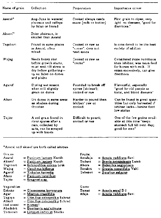
TABLE 3-4 Commonly Used Wild Grains
and Other Wild Foods
TABLE 3-4 Commonly Used Wild Grains and Other Wild Foods
|
Name of grain |
Collection |
Preparation |
Importance or use |
|
Asaral. |
Aug-June in watered plateaux and valleys by Iklan or Imrad |
Cooked always needs sauce (milk or butter) |
First grain to ripen; very light; no diseases; "good for
diarrhoea." |
|
Akasof. |
Drier plateaux is smaller than Asaral |
|
|
|
Tegebart |
Found in same places as Asaral, often mixed |
Cooked or raw as "creme"; does not need sauce |
Is considered to be the best variety of ishiban |
|
Wajag |
Needs heavy rain before growth starts, must wait till straw is
dry before gathering-- by an Iklan on dunes and plains |
Cooked or raw as "creme" |
Considered more nutritious than ishiban; was main feed for hones
with milk. If eaten excessively, can give diarrhoea |
|
Agarof |
During wet season when still slightly green on dunes |
Pounded to break off spines (vicious!); cooked or raw |
Flavourful, especially "good for old people as tonic, and blood
diseases" |
|
Afaso |
On dunes in same areas as ishaban during October |
Harder to pound than ishiban'raw or cooked |
Can be found in great quan tities but only harvested if ishiban
lacks--famine food low status |
|
Tajite |
A red grain Sound in clear spaces after a rain, collected by
ants, can be scraped up with hands |
Difficult to pount; cooked or raw day; stomach full till next
good for men" |
One of the few grains avail able at this time "keeps |
*Asaral and akasof are both called ishiban
|
Grains: |
Fruits: |
|
Asaral = Panicum laetum Kunth |
Amalaja = Acacia raddiana Savi |
|
Akasof = Panicum laetum Kunth |
Tadant = Boscia senegalensis Lamk. |
|
Tegebart = Echinochloa corona Link |
Abora = Balanites aegyptiaca |
|
Wajag = Cenchrus biflorus |
Terakot = Grewia populifolia Vahl. |
|
Agarof = Tribulus terrestis |
Tabakot = Ziziphus saharae |
|
Afaso = Panicum turgidum |
|
|
Tajite = Eragrostis sp. |
|
|
Vegetables: |
Gums: |
|
Eshako = Glossonema bovennum |
Tamat = Acacia seyal Dil |
|
Agar = Maerus crassifolis |
Afaja = Acacia raddiana Savi |
|
Tagoya = Citrullus colocynthis Schrad |
|
|
Alikid = Citrullus colocynthis Schrad |
|
|
Ibellawent = Rumex |
|
|
Abedebit = Boerhavia aggulutinans |
|
|
Tamasalt = Limeum indicum Stacks |
|
Domestic grains (wet rice, millet, and occasionally sorghum)
that are grown by sedentary agriculturists along the Niger River were
traditionally supplied to the nomads as tribute, but now the nomads purchase
them when the wild grains are unavailable or for special occasions. Domestic
forms constitute roughly half of the grain eaten by nobles, but only a quarter
for the iklan, although this depends on the size of the harvests. During the
months from September to January, ishiban and wajag are eaten by everyone, but
as the supplies diminish, the wealthy nomads and imajaren eat an increasingly
greater proportion of domesticated grains, whereas the poorer people resort to
the less common wild grains, for example, Tribulus terrestris (agarof), as shown
in table 3-6.
Both domestic and wild grains are pounded in a wooden mortar to
remove the bran; it is then separated from the grain by shaking from one flat
basket to another, the process also used for removing sand. No stone querns,
pestles, or grinding stones were observed among the Tamasheq in the Sahel,
although Nicolaisen (1963) and Gast (1968) note their use in the northern
Sahara. The bran is frequently given to slaves and is eaten either raw or
cooked. The cleaned grain is boiled in open metal pots, then eaten with butter,
pounded meat, or sour milk and salt.
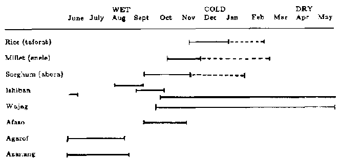
TABLE 3-5 Harvest Periods of Major
Domestic and Wild Grains
Vegetables are consumed mainly when other foods are scarce, or
by children of lower status groups. This is largely due to prohibitions against
eating them (held by higher class Tamasheq, as well as by the slaves and
artisans who live with them), and perhaps also to their relative scarcity in the
Sahel. Vegetables are usually cooked in water, although the melons (tilagarien)
may be roasted in hot ashes. Some (for example, tatola) are eaten raw, but this
is rare.
Fruits are generally taboo, although small dried berries of
Ziziphus Spp. (tabakat) and Grewia tenax (terakat), which are gathered by iklan
during August and September, are sometimes used as a sweetening for sour milk.
Iklan and artisan children also collect and enjoy "desert date" (aborak) and the
gums of several trees. Aborak is the fruit of Balanites aegyptiaca, and not of
the wild Senegal date palm, P.reclinata. The fruit of the domesticated date
palm, P. dactylifera, are also used for sweetening, but they are scarce; they
are not found in the Sahel, but are acquired through trade with northern oases
dwellers. Some leaves that are used as medicines, Cassia obovata (agargar), for
example, may impart some nutrition; they are usually chewed or brewed as tea.
(Species of vegetables, fruits, and gums and the mode of preparation are listed
in table 3-7.)
The imajaren are prohibited from eating fish and insects as
well, but other groups, especially those whose nomadic patterns bring them close
to the Niger River, eat fish. Use of locusts has been noted among the Tamasheq
tribes of the Sahara by Foley (1930:209) and Gast (1968: 251).
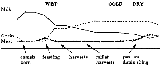
TABLE: 3-6 Proportion of Milk, Meat,
and Grain in Diet According to Season
TABLE 3-7 Commonly Used Vegetables,
Fruit, and Gums
Meat of domesticated animals is used mainly on special occasions
such as religious festivals, the arrival of visitors, or major camp movements,
and for medicinal purposes, although Kel Tamasheq believe that meat should be
eaten at least every week in order to maintain health. They have been known to
stage a "special occasion" to justify butchering an animal. Goats are most
frequently used because they are least valuable and are generally kept near the
camp. A larger animal may be butchered when meat is scarce, if there are many
visitors, or if it is too weak (from thirst, hunger, or travel), old, or sick to
continue. However, the latter depends on the type of infirmity; victims of
contagious bovine pleuropneumonia, for example, are not eaten.
Wild animals are seldom eaten; this may be partly because of
their current scarcity, food taboos, or possibly the lack of means or expertise
in hunting. (Weapons consist only of knives and throwing spears; no bows are
used except as toys.)
Animals are killed by slitting the throat. Blood and stomach
contents are the only parts not used, and the meat is divided according to
strict social rules: the chest to marabouts, if present; the ribs to the man of
highest rank; the head to the shepherd or owner of the herd; the neck to elders
in the shepherd's family (if he is young); the stomach and intestines to the
iklan; the lower legs to children; and the rest to the owner of the animal. This
pattern differs slightly according to the type of animal. Large animals such as
camels or cows must be partitioned among the whole camp; sheep and goats are
primarily for the family that butchered them, although almost anyone may come to
eat with that family or ask for some of the meat. Organ meats (liver, heart) are
roasted on hot coals immediately after butchering and are eaten with salt by the
head of the family and respected guests. Later, the haunch and meaty portions
are prepared in any of the following three ways: (1) roasted by being buried in
the sand with a fire built on top; (2) boiled in water with the meat then
removed from the bones and pounded in a mortar to break up the fibres, then
served with grain, or very rarely, with butter only; (3) cut from the bones,
then divided into thin pieces and hung inside the tent to dry. Bones are
discarded.
Fresh milk is the first meal of the day for children and is
taken at dawn; the adults drink only sweet tea and chew tobacco. At midmorning,
"cr�me" is eaten by men and children, and less frequently by women. In early
afternoon, a major meal of grain with either meat, butter, or milk is prepared,
if grain is available. In the evening, fresh milk is drunk by all, occasionally
supplemented by a small dish of grain if milk is scarce. Visitors are usually
given a meal of meat and grain, preferably millet or rice, in the evening.
Food is served in wooden bowls with four or five people
partaking from each, using either the hand or a wooden spoon. Bones are broken
open with knives or "Neolithic" stone implements to obtain the marrow; the bones
are then thrown outside the tent. If the camp remains in one place for more than
a few days, such debris will be swept further away from the tent (8 to 10 m).
Occasionally, dogs (one or two of which are present in most camps) will scatter
bones further. However, scavenging is not their main means of obtaining food,
since they are fed on milk and grain when it is available. Bones seem to
accumulate on the west side of the tent during the cold season and on the east
side during the hot months. (At other times, camps are not stationary long
enough for debris to concentrate.) This difference may be due to the fact that
in winter meat is eaten to celebrate the arrival of visitors and is served with
the evening meal when people sit on the west side (perhaps for protection
against easterly winds). During the hot season, however, meat is most frequently
eaten at the main afternoon meal when tent occupants gather on the shady east
side. Meat has less of a ceremonial function at this time, since visitors are
not common; it is more important as a food source because milk and grain are
insufficient and also because many animals die of starvation or thirst during
the hot season and must be slaughtered.
Determinants of Movement
The nomads' most common response to pressures from the physical
and social environment (hunger, thirst, political hostility) is to move. It is
one of the most effective means of exploiting widely scattered and scarce
resources. The precise nature of the movement (its time, frequency, direction,
and distance) is the result of a complex interplay between the needs of people
and animals and the availability of food and water, the latter being the most
critical commodity.
Kel Tamasheq do not wander randomly, but circulate within
general "home" regions, and within these regions, follow a habitual route, for
example, south to north to south again, although both the region and the route
can change in response to unusual political or seasonal situations. The nomadic
pattern is oriented toward seasonal water points and key pasture areas (figure
3-1).
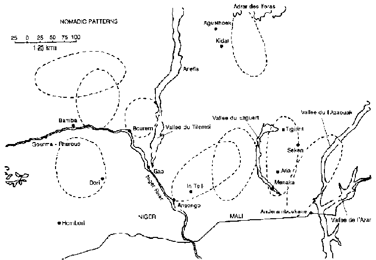
FIGURE 3-1 Approximate extent of
areas occupied by nomadic pastoral groups in the vicinity of the lower Tilemsi
Valley, Mali.
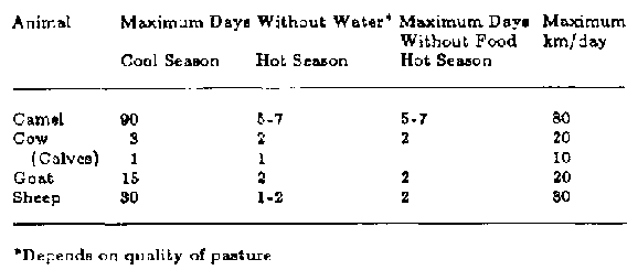
TABLE 3-8 Resistance of Animals to
Thirst, Hunger, and Fatigue
TABLE 3-8 Resistance of Animals to Thirst, Hunger, and Fatigue
|
Animal |
Maximum Days Cool Season |
Without Water* Hot Season |
Maximum Days Without Food Hot Season |
Maximum km/day |
|
Camel |
90 |
5-7 |
5-7 |
80 |
|
Cow |
3 |
2 |
2 |
20 |
|
(Calves) |
1 |
1 |
|
10 |
|
Goat |
15 |
2 |
2 |
20 |
|
Sheep |
30 |
1-2 |
2 |
30 |
*Depends on quality of pasture.
In the first months after the rains, from September to December,
water is obtained from shallow, handdug wells that are usually surrounded by
adequate pasture. Camps are located near the water, and this enables the group
to remain in place for as much as a month at a time. As this water dries up,
usually between January and February, groups move toward more permanent sources,
such as bore-holes or the traditional hand-dug wells in beds of now-dry lakes.
As pasture is consumed in all directions around these wells, the camps move
gradually outward, spending no more than a week in one spot, until the distance
between water and pasture is the limit that mature cows and caprines can travel
(table 3-8). At this point, occurring at the height of the dry season when it is
tied to one water source, the camp is positioned between the well and the
pasture and, again, remains immobile for several weeks. The exact placement of
the camp itself at this and all other times is determined by the water
requirements of the young animals that remain inside the camps, as well as by
those of the people themselves. Lambs, kids, and humans do not require great
quantities of water (sufficient amounts can be carried in leather water bags for
two days' supply), but since calves drink more, they must be taken directly to
the water source every day. The extent of their daily travel depends on age and
physical condition, but is unlikely to exceed 10 km each way. It can be
postulated, then, that it is the calves that determine the exact distance of the
camp from water.
On the other hand, the crucial decision of when to move appears
to depend on the food needs of mature animals, specifically those that are
lactating. They must return to the camp each evening to be milked and to feed
their young, and therefore cannot travel more than 20 km (for cows) in search of
pasture. To ensure their return, herders send the mothers in one direction and
their young in another, on the theory that in the evening both will converge on
the camp - the young being hungry and the females seeking relief; if, however,
the two somehow meet while grazing (a not uncommon occurrence), neither comes
back to camp. When the pasture is consumed beyond this limit, the camp and herds
must move to another permanent water source or possibly, if it is near the usual
end of the dry season or if the source is beyond the capabilities of the animals
to walk, the group may remain and try to eke out a living until the rains come.
In either case, and especially when the rains are delayed, a considerable toll
is taken in animals.
Such extreme conditions do not occur every year, but they serve
to illustrate the critical balance that exists between man and land at all times
in a marginal environment. Nomadic life requires a sensitive evaluation of the
needs of animals and an awareness of where the optimum supply of water and
pasture can be found. Increase in population or change in environmental
conditions may bring nomads into competition for these limited resources. It
seems likely that these mechanisms were at work 4,000 years ago when the
prehistoric pastoralists were being forced out of the Sahara to find new and
more permanent water sources.
During the wet season, an entirely different set of
considerations dictates the location of camps and the time of movement. The
needs of animals are no longer critical - new grass is growing and water is
available everywhere in streams and shallow lakes. At this time, the mature
nonlactating animals (which until now have been totally independent of the camps
and wandering freely in search of food and water) are rounded up, a process that
may take several weeks. When all the animals have eaten enough new grass to
regain strength lost during the hot season, the camp and its consolidated herds
embark on a month-long journey to areas of salt earth ("terre sal�e") which are
generally located to the north on the edge of the Sahara (the precise area
differs for each region). This trek serves both a health and a social function.
In the first case, it allows the animals to graze on salt grasses and drink
water of high mineral content, which the nomads believe is necessary for the
health of both their animals and themselves. In the second, since related tribes
usually frequent the same terre sal�e this is a time of feasting, competitive
sports (camel racing, wrestling), and, above all, courtship.
During the wet season, the camps usually move each day or every
other day, although the exact speed and frequency of movement depends on the
strength of the young animals that are usually being born at this time; for
example, newly born camels must rest at least a day after birth before they can
travel, and even then they may not be able to keep up with the herd; a herder
will often drop back to walk with the mother and infant. Progress is often
slowed also by the need to retrieve the animals that have wandered during the
previous night (during seasons when movement is infrequent, the trek animals are
collected and hobbled the day before, but when camp is being moved each day, the
animals must be left free to graze at night). A minor factor affecting the speed
with which the salt areas are attained is the search for appropriate routes.
Large lakes must be skirted, and in the Sahara region good water and pasture
again become a problem. The northward journey, then, is not direct but carried
out in a zigzag fashion (figure 3-2).
During all seasons, the distance that a camp moves at any one
time strictly depends on the availability of water and pasture, but it normally
ranges between 2 km and 30 km. Movement begins at dawn (it takes approximately
half an hour to break camp) and continues only until noon. If still more
territory needs to be covered, the journey will resume after the day's heat
diminishes.
During August and September, the movement pattern of iklan both
those who are a component of other camps and those who are independent, is
slightly different from that of the nobles and marabouts, since it is influenced
by their search for wild grains. At the time of the first harvest, iklan groups
will converge upon the areas that have been favored by rain or soil conditions.
If the yield is abundant, the second and third harvests will be limited to the
collection of grains encountered while herding; movements will be less affected
by the need to harvest.
A local variation of the general pattern of movement is found
among groups living near the Niger River, especially those between Timbuktu and
Gao. At the end of the hot season, and especially if it is prolonged or severe,
the groups will reverse their pattern of following the diminishing pasture away
from the river and make a forced march back toward it through now barren country
in order to feed their animals on the plant species, such as Echinochloa
stagnina (burgu), exposed by the lowered water levels.
Movement of all groups is influenced by death and disease.
Nomads are aware of the danger of contagion and will isolate the tent of one who
has an infectious illness. When traveling, they will try to pass on the upwind
side of a stricken camp. When a person dies, he is buried several hundred meters
from the camp, oriented to the east in the Muslim fashion, and the grave is
covered with straw, after which, ideally, the camp will be moved. Kel Tamasheq
do not condone amputation, surgery, or mutilation of the body, even in order to
save life.
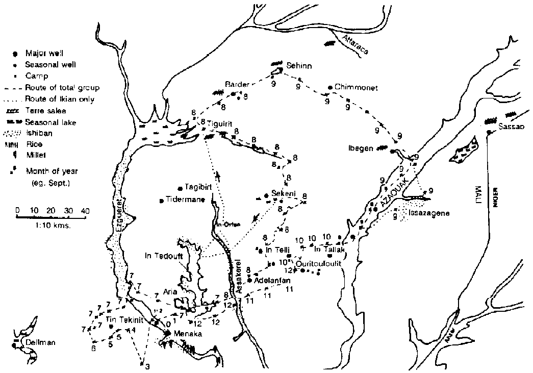
FIGURE 3-2 Seasonal pattern of
movement by one nomadic group in southern
Mali.
Camp organization
The necessity for more or less constant movement has greatly
influenced both the material culture and the living pattern of the Kel Tamasheq.
The former is restricted to household necessities that are light and not easily
broken; for this reason, little pottery is used; most vessels are made of wood.
The only item of pottery noted in one of the camps was a large broken pot (1 m
diameter) in which hides were soaked to remove the hair before tanning. With
superfluous items cut to a minimum, aesthetics are expressed in such functional
items as carved tent poles, beds, bowls, and intricately woven mats, as well as
through personal decoration - hair styles, necklaces, swords, charms, and
leather wallets.
Tents are the logical response to needs for a shelter that can
be quickly and easily dismantled and rebuilt during seasons of rapid movement
(figure 3-3). Tents are placed over a framework of wooden poles; these poles are
lashed together with ropes made from the bark of Acacia tortilis (afagag). They
are fashioned from goat or cow hides, the number depending on the wealth or
social status of the occupant - from as few as 4 to as many as 60 - sewn
together with thongs. They constitute the heaviest and bulkiest item of the Kel
Tamasheq's gear, but this weight is necessary: the tents must withstand the high
winds and torrential rains of the wet season. During these storms, the nomads
secure the tents by tying their edges to the bases of the auxiliary tent
supports and by throwing across the tent ropes, whose ends are knotted around
straw and buried in holes 1 m deep. Tents have an average life of 10 years and
are easily repaired by stitching circular patches of leather over rips or holes.
During the hot season, when the camps are stationary for weeks at a time, straw
huts are constructed that are cooler than the dark tents; the latter are
stretched out on the ground where they are mended and butter is melted into the
leather by the hot sun to soften and preserve the skin. Red ochre (temesgeit) is
then rubbed in as an additional preservative.
Camps are located in relation to natural features according to
the season. In the cooler months (September-November and February March), the
camp is placed near areas of small trees or bushes that can provide fodder for
young goats. In the cold months of December and January, the camp is moved into
the shadow of an acacia "forest," or, if that is unavailable, near a large dune
to gain protection from the cold winds. During the hot and rainy seasons, the
camps are made on top of high dunes to take advantage of cooling breezes during
the hot season and to avoid the mosquitoes and water runoff associated with the
rainy season.
The nomads explain that at no time are camps placed within 100 m
of a water source, since it is prohibited to eat in such places.
Within the camps, there appears to be no pattern regarding the
placement of tents other than personal preference (some family heads prefer
higher ground, others like to camp beside a tree, and some families habitually
camp near each other because they get along well or have herds in common). The
exceptions are that tents of slaves who care primarily for camels (iklan n
iminas) will be placed to the east of the master's tent and the tents of those
who are "slaves of the cows" (iklan n fess) are always to the west. Tents of the
artisans are generally situated in a cluster to the west of the camp. The chief
or most respected person chooses his place first and the others follow,
apparently in order of seniority. Tents appear to be always oriented toward the
east, which is contrary to the observations of others: (Briggs, 1960) in the
northern Sahara, and Nicolaisen (1963) among the Kel Ayr. Baggage is piled on
the north and south sides allowing the east and west sides to be opened when
sunlight, and sometimes wind, is not coming from these directions (at noon,
tents are opened on both sides to give maximum shade and ventilation).
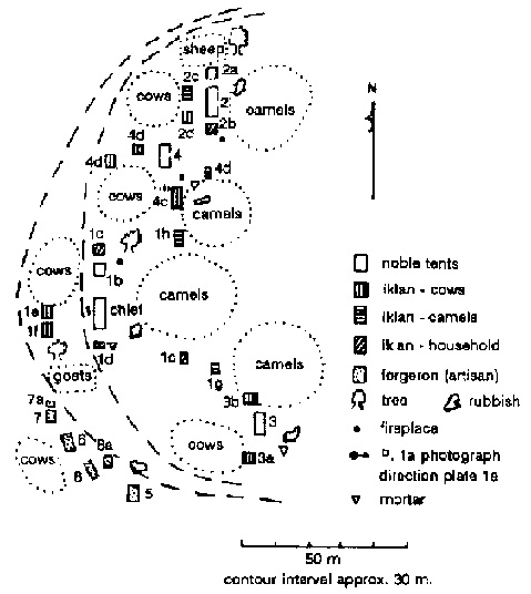
FIGURE 3-4 Typical pastoral nomad's
camp on a sand dune during the wet season.
The distance between tents varies according to the terrain. On
small dune tops, the major family tents of nobles, for example, may be as close
as 10 m to each other, with the household slave tents clustered within 2 m
(figure 3-4), whereas on open plains they may be separated by 40 m, (figure 3-5)
obliging the women to ride donkeys when visiting friends on the opposite side of
the camp.
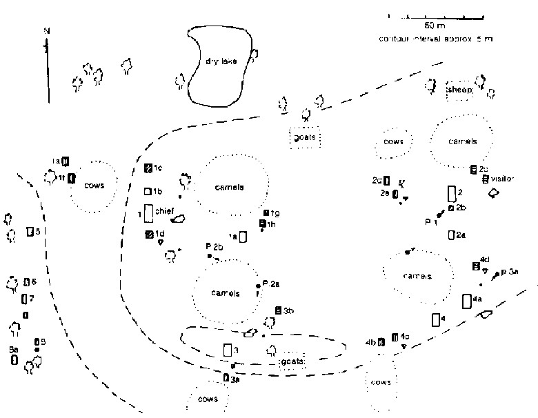
FIGURE 3-5 Typical pastoral nomad's
camp on the open plateau during the hot season.
Camps as a whole are vaguely crescent- or U-shaped. At night
when the animals return to the camp for milking, the camels are placed on the
inside, and goats, sheep, and cattle lie outside. There is no rigid rule
concerning this and it is largely a matter of what is most convenient for those
who care for them. Newborn sheep and goats are kept inside the tents. Older ones
are allowed to run free in the camp during the day but are tied by their necks
to a rope stretched between two stakes at night. Bush enclosures are sometimes
made to protect goats and sheep from jackals. Newborn camels are tied by one
foreleg to individual stakes in the middle of the camel yard; when older ones
come back from pasture they are tethered in a group to one stake. Calves are
tied individually by the neck at night and are sent to pasture during the day.
Donkeys'front feet are hobbled when they are likely to be needed, but otherwise
they are allowed to roam freely. It must be emphasized that it is only young
animals and mature lactating females that are usually found in the camps; the
others are brought in only when camp is about to be moved and even then not all
are found.
Since material culture is limited among the nomads, abandoned
cool-season campsites are indicated only by trampled earth, dung, lack of grass
in the surrounding area, and a few wooden branches used as auxiliary tent
supports. Hot-weather sites may show traces of straw huts, and rainy season
camps often have remains of "nests" that children build in trees to escape the
mosquitoes, or occasionally, bed supports that lift sleeping mats 1-1.5 m off
the ground for the same purpose. There are sometimes remnants of charred
branches left from the huge bonfires that are built during wet-season storms to
keep goats from stampeding. In the section of the camp inhabited by artisans,
small pieces of brass and iron staples used for mending chips and cracks in
wooden bowls may be found. Also, there are discarded pods of Acacia nilotica
(tagart) that have been used for tanning hides, as well as numerous strips of
leather and pieces of matter. Nearby trees may have scars where strips of bark
have been removed for use in medicines, tanning, and rope making, depending on
the type of tree. In noble camps, the pounding and winnowing of grains is done
by (iklan beside their tents; therefore, seeds and chaff may remain in these
areas. Cooking fires are usually built near the tents of the household (iklan
whereas fires for warmth, used only during the cold months, are located directly
in front of the imajaren tents. No stones are placed around campfires, and such
places are indicated only by darkened sand, charcoal, and ashes (however, this
could be because of the scarcity of rocks in the areas observed). The precise
location of tents is indicated by areas swept free of dung and straw. The debris
from the tents (such as cooked grains, seeds of tarakot, excrete of babies,
camel dung and wood fragments used for games, and pieces of charcoal used for
heating tea) are accumulated about 10 m to the east or west of the tent site,
where the bones have also been thrown.
The population density is approximately 0.3 individuals per
square kilometer. The size of the camps depends primarily on the social class of
the members, since a camp of noble Kel Tamasheq would include their slaves and
artisans as well as their own families. Secondly, size depends on the
availability of pasture; a large camp may split if there is insufficient food
for the animals. Some nomads maintain that in the past, camps were considerably
larger, perhaps consisting of several hundred people, because pasture was more
plentiful. Others insist that this only appears to be the case because either
the individual camps of 100 were more common, as slaves who now travel
independently formerly lived with their masters, or these small camps would
migrate as a group for protection against enemies rather than in dispersed units
as they now do.
An example of the layout and demographic composition of a large
Kel Tamasheq camp (Oulliminden) is presented in figures 3-4 and 3-5 and table
3-9 respectively. The sexual distribution varies with the season, since during
the months of February to May and September to November the males often make
journeys to sell animals and buy necessities, collect taxes and tribute, conduct
raids on enemies, or just visit. Recent major epidemics of smallpox, measles,
pneumonia, and meningitis have decimated the youngest and oldest age groups. (In
the past, war appears to have been a more significant factor in mortality than
was disease.) A few small groups differ significantly from this model, for their
social codes have inhibited marriage and, consequently, they are suffering major
population declines.
Herd size reflects the wealth of the owner but not his social
status, since, at present, there are slaves and vassals who have more animals
than do the nobles. Traditionally, however, the noble was considered to own the
animals of his slaves and to have access to those of his vassals. The number of
(iklan tents associated with an imajaren, vassal, or marabout tent is, on the
other hand, an indicator of status. For example, the largest herds among the Kel
Tamasheq are owned by the vassal tribe, Deousahak, but they do not have iklan
and care for the animals themselves.
Conclusion
This description of the habitation and exploitation pattern of a
nomadic pastoralist group in a marginal environment with relatively harsh
climate and scarce resources is suggested as a possible analogy with
post-Palaeolithic herding peoples who inhabited the Saharan and Sahel zones cat
4000-1300 B.C. This pattern utilizes almost all of the resources of the
environment, either directly or through the medium of animals, and obtains them
in sufficient quantities to sustain life by movement from area to area.
In terms of non-food resources, wood is the major element drawn
directly from the environment. It provides heat for cooking, and is used for
making tent supports, beds, vessels, and eating utensils.
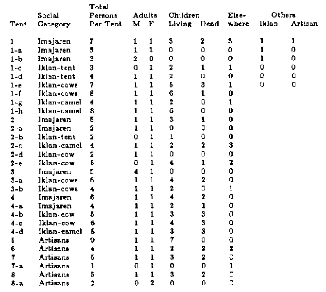
TABLE 3-9 Demographic Composition of
a Tamasheq Camp (June 1972)
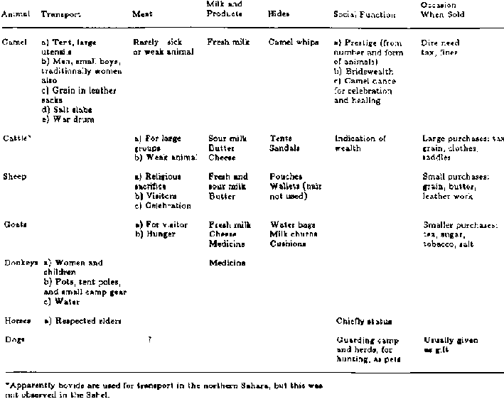
Table 3-10 Comparison of uses of
various domestic animals
The food resources directly available are vegetables, fruits,
birds, fish, and wild grains. Food taboos restrict the use of a number of these
items, especially among the noble classes, but wild grains are an important
source of seasonal food for all. The primary subsistence sources, however, are
the domesticated anneals. They supply food and are the means for acquisition,
through trade, of other goods, such as clothing, knives, and domesticated grain;
they provide many of the raw materials necessary for nomadic life-hides for
tents, sandals, and saddles, and urine and excrete for medicines; they are the
means of transporting both people and camp gear (table 3-10). The animals, thus,
are the primary link between the Kel Tamasheq and their environment, the West
African Sahel, and their welfare largely determines the welfare of the
people.
References
Bernus, E. 1967. Cueillette et exploitation des resources
spontan�es du Sahel nig�rien par les Kel Tamasheq. Cahier ORSTOM, S�ries
Sciences Humaines 4(1):31-52.
Briggs, L. C. 1960. Tribes of the Sahara. Harvard University
Press, Cambridge, Massachusetts, USA.
Dorst, J. and F. Dandelot. 1970. A Field Guide to the Larger
Mammals of Africa. Collins, London, England.
Gast, M. 1968. Alimentation des populations de l'Ahaggar.
Alg�rie: M�moirs du Centre de Recherches Anthropologiques, Pr�historiques et
Ethnographiques, Algiers, Algeria.
N'Diay�, B. 1970. Groupes ethnigues au Mali. Editions
Populaires, Bamako, Mali. Nicholas, F. 1950. Tamesnas Les loullemmeden de l'est
ou Towareq "Kel Dinnick" Imprimerie Nationale, Paris, France.
Nicolaisen, J. 1963. Ecology and Culture of the Pastoral Twareg:
With Particular Reference to the Tuareg of Ahaggar and Ayr. The National Museum,
Copenhagen, Denmark.
Richer, A. 1924. Les Touareg du Niger (R�gion de
Tombouctou-Gao). Les Oulliminden. Emile Larose, Paris,
France.
Dromedary pastoralism in Africa and Arabia
GUDRUN DAHL AND ANDERS
HJORT
Introduction
This paper provides an overview of different economic systems in
which the breeding and ownership of camels play a significant role; it explores
some of the strengths and weaknesses of such systems. The emphasis is on camel
pastoralism in Africa and Arabia. ("Camel" here refers to the dromedary.)
While a number of anthropological efforts are focused on more
general studies of cattle pastoralism, few efforts have been made within the
equivalent field of camel pastoralism. One exception is Rubel (1969), who has
tried to create a "generative model" for residential and kinship patterns,
comparing a number of pastoral societies with varying emphasis on camels or
small livestock. Her hypothesis is that small-stock pastoralism necessitates a
wider range of pasture and water than camel pastoralism, and that this need for
resources in turn affects the social structure of the herders' groups: the
strict ideal of patrilinearity must be compromised in practice so the
small-stock herder can maintain a widespread network of alliances also outside
his patrikin, ensuring access to such resources. Rubel has been criticized
(Pastner, 1971) for using untrustworthy data and for relying too heavily on
simplistic assumptions about the hardiness of camels. One of her critics, Lewis
(1975; 1977), however, notes the correlation between cultural differences and
variations in "species emphasis" among neighboring pastoral peoples in northern
Kenya and suggests that different combinations of livestock could indeed provide
a generative model for predicting forms of social organization.
Our focus is on systems of production rather than on particular
groups of people or their cultural traits, and we are concerned both with
constraints that may be caused by ecology and an economic dependence on camel
herds, and with restrictions on production caused by the social
organization.
Reproduction and risk
Camel keeping is fundamentally a high-risk undertaking (Sweet,
1965), due to the animals' very slow reproduction rate. Only when she is about
six years old does the camel dam start to bear calves, and then normally only
one calf every second year. In contrast, the cow first calves at about three or
four years of age, and then every year thereafter. If a camel owner is struck by
misfortune and left only with a minimal number of camels or none at all,
rebuilding the herd is a very slow process. Breeding animals are very expensive
to buy, and owners are often reluctant to part with them. Lost camels, in many
cases, are never replaced; the loss is as final as when a farmer or peasant
becomes landless. A dramatic example is the fate of the Sakuye Borana in
northern Kenya, who lost virtually all their camels during a war in the early
1970s. Practically all the Sakuye were pushed out of their traditional
livelihood, because they were unable to provide proper care for the remaining
animals and were incapable of expanding their holdings fast enough to reenter
viable pastoralism. They were forced to leave their area to seek other income
and thereby lost effective control over their pastures, which were subsequently
used by other camel herders. It is now almost impossible for even rich Sakuye to
purchase breeding animals in the market (Dahl and Hjort, 1979).
The hazards of camel reproduction have also been used as an
explanatory variable by authors (notably Sweet, 1965) who have sought to
understand the institutionalization of raiding in Arabian camel-owning
societies. By acquiring animals in a raid, the herd owner can preclude several
unproductive years in the development of his herd. One partial solution to the
risk is that many camel-owning societies in Africa and Arabia have systems of
property holding that redistribute the risks among herd owners. All the animals
of a particular patrilineal kinship group are in some sense regarded as common
property and are marked with one single brand. Each individual herd owner,
however, can dispose of his stock as he pleases, as long as he fulfills his
duties to take part in lineage redistribution of stock to those stricken by
misfortune. Such redistributions may be organized by a council consisting of all
mature herd owners in the lineage, or by specially appointed elders or tribal
chiefs (Dahl, 1979). Among the Sakuye, the lineage members were responsible for
helping each other to retrieve lost stock and to make a collection of a nucleus
herd for any member who had lost his camels through misfortune; this was on the
condition, however, that he was not known to have spent capital (female breeding
stock) carelessly (for example, by selling it). (Due to the high risks
associated with herd regeneration, the camel husbandman must show respect for
capital expenditure: the cultural system often stresses this by various
semi-ritual taboos against sales.) When a majority of the camels of the Sakuye
people had been lost, such countermeasures as lineage redistribution were of
course ineffective.
Forms of lineage redistribution may be supplemented with systems
of mutual loans of camels; in practice, then, the herd that is managed by one
household belongs to many owners. Such a system of chains of loans has been
described by Spencer (1973) for the Sakuye's neighbors, the
Rendille.
Management and labor
It is not only the pattern of herd reproduction that is
significantly different for camels and cattle. Camels are able to move quickly
and to reach distant pastures. Such movements are necessary to achieve a varied
diet. In comparison with cattle, camels require frequent "salt cures" at licks
or on pasture on salty soils unless there is access to water with appropriate
mineral content. Mobility is also needed to avoid hygienic problems and tick
infestation. Camel calves are highly vulnerable to ticks, and as a
countermeasure the pastoral camp should not remain more than 10 days at the same
place. Camel oriented societies differ in the degree that the main body of
household members follows the camel herd in all its moves; but when they do,
much energy is spent on the frequent erection and dismantling of tents. Camp
moves are usually more frequent than among cattle herders.
Neither mating nor birth can be left to the camels themselves:
the attention of experienced herdsmen is necessary. Camels, especially dams
about to calve, have a tendency to stray, and tracking them involves much work.
Although camels frequently go for long periods without water,
they drink a great deal whenever they can. In the dry seasons, it can be quite a
task to draw 90 liters of water per animal from a deep well. Watering at ponds
or reservoirs, which is easy with cattle, requires great attention with camels,
especially at places where livestock of other species are watered as well.
Camels tend to get into the water and foul it and animals of other species
refuse to drink it.
Camel pastoralism can generally be said to be more troublesome
and demanding than cattle pastoralism, though there are seasonal changes to the
pattern. Two slightly different examples can be mentioned, one from southern
Arabia and the other from Kenya.
Among the Al-Murrah of Rub' al-Khali, the members of a
particular patrilineal group tend to congregate around its oasis or permanent
well during the hot season. There is not much herding to be done, as the
vegetation is restricted to narrow and isolated patches and the camels do not
stray far from the watering places. By contrast, the cool season is a period
when much time has to be spent in aiding mating and calving and in tracking
wandering camels (Cole, 1975). It is a time of plenty of milk and easy access to
water and pastures. Families gather together and meet other patrilineal groups.
There is much interclan feasting.
In northern Kenya, the rainy season similarly involves both work
linked to camel reproduction and to congregation and enjoyment. Since resources
are abundant, but also because the areas open to camels become restricted, herds
and people are concentrated in areas with good drainage. Families that tend to
be parceled out into many small sub-units during the dry season are able to stay
together in the rainy season. As drought proceeds, the main camps must live
closer to the permanent waters, but the camel herds and their herdsmen roam
widely in search of pasture. "Almost every able-bodied person, including
children from the age of seven, is pressed into service...." (Tarry, 1978). Wet
season routines sometimes demand a very intensive input of labor by a restricted
number of people. Dry season routines, on the other hand, put a strain on the
number of people available because there is a proliferation of tasks.
One way of countering the high risk of camel pastoralism is to
combine camel rearing with the rearing of sheep and goats that reproduce quickly
and so provide a viable pastoralism and a hedge against misfortune, but this
also implies serious constraints on manpower. For example, Torry (1977)
indicates that for the Gabbra in northern Kenya, the labor-intensive nature of
multispecies stock management denies able-bodied persons considerable freedom
from productive work during certain periods, especially as compared with cattle
pastoralism. The Gabbra normally keep different kinds of stock in their
household property, and most Gabbra households are dependent on immigrant labor
at critical seasons. Gabbra households in a camp also try to pool labor
resources to care for the family herds through such periods.
Because each form of livestock has needs differing from those of
other forms of livestock, the minimal number of herdsmen must be large in order
to provide specialized care to each species.
Even a family that owns only camels must still give special
attention to the several categories of camels. Among the Sakuye, for example, it
is said that herd owners tried to mate all their dams with the same male and
then to separate this group from contact with other males until it could be
seen, after one to four months, whether the dams were pregnant, lest other
rutting males cause miscarriages or injure the darns. The dams and their sire
would be sent away, while the newborn calves and their mothers, which
constituted another group demanding special attention, were kept close to the
camp. This group was put under a rule of ritual seclusion and could only be
herded and milked by chaste young herd boys. Among the Al-Murrah, Cole (1975)
found that there was particular concern over a similar category of newborn camel
calves and their mothers that had to be given water every week; these were kept
separate from both the mobile milch camels and the pregnant dams, which were
left unattended close to the
camp.
Subsistence production
In spite of the fact that there are many monographs on groups
concerned with camel herding, detailed production data are scanty. The main food
product obtained from a camel herd is milk. The camel is in many ways a more
reliable source of milk than the cow. She produces milk in greater quantity. To
mention but one example, a Sakuye camel dam in northern Kenya can be expected to
give about 4 kg daily as compared with 0.5-1.5 kg for a cow in the same area. At
the peak of lactation, the daily yield can be as much as 12 kg. Knoess (1976)
found average daily milk yields of between 2 and 8.4 kg in Afar camels in
Ethiopia. The lactation period may last for 18 months: up to a year is
considered normal under traditional pastoral management. This means that the
owner of a number of camels can have safe access to milk throughout the year.
In areas with only one rainy season, a majority of the camels
are sometimes at the end of their lactation just before the onset of the rains,
and the end of the dry season may involve a critical period of food shortage for
the pastoralist if he has no access to grain or other products that are
unrelated to camel rearing. It is interesting to note that one of the few areas
where there are almost totally subsistence-oriented camel pastoralists is in
northern Kenya, which has an expected pattern of two rains per year. There,
sections of the Rendille and Gabbra live almost exclusively on the products of
their camels and small stock.
There are, however, some impediments to milk production even in
that region. If one or two consecutive rains fail, there may be a delay in camel
reproduction - and hence in lactation - which is more serious than such delays
would be in cattle rearing or small stock pastoralism. A camel may go one or
even two years without beginning a new lactation. Moreover, there is a risk that
all the camels go in milk simultaneously, which gives one year of abundance at
the cost of the next year's milk supply.
Milch goats and sheep for slaughter ensure a more reliable
supply of food. Goats come into milk quickly after the onset of rains. This is
one of the reasons that camel rearing is frequently combined with the husbandry
of small stock.
Subsistence pastoralists rarely slaughter camels for meat.
Slaughter is reserved for ritual occasions or when there are other large
gatherings or when the camel is old or weak, and even then it depends upon the
value of females for reproduction and of males for a wide range of alternative
uses. To slaughter a camel is a major decision, but the gap left when a goat or
sheep is killed is quickly filled: the meat of the smaller animal can also
easily be consumed by the family without involving any larger group in communal
sharing.
In northern Kenya, camels are occasionally bled to provide for
particular human demands of iron, salt, and other nutrients. The use of camel
blood as human food seems to be restricted to those Nilotic peoples who have
acquired camels (notably the Turkana), to camel-owning Borana groups, and to the
most western Somali. It is not acceptable to orthodox Muslims.
Apart from the production of milk, meat, and blood, camels
supply skins and, theoretically at least, wool. Knoess (1976), who suggests that
Afar pastoralists be made to sell camel wool, notes that its use is unknown in
Ethiopia, and the same is true for the rest of the Horn of Africa. Skins are
used by pastoralists for household utensils, whips, and sandals (which are
sometimes
exported).
Marketing
The only area in the world where camel pastoralism seems to be
predominantly subsistence-oriented is northern Kenya. Even there, camel
pastoralists rely to some extent on neighbors practicing hunting or alternate
forms of pastoralism. Most other camel pastoralists depend on exchanging some
form of goods or services with their neighbors to obtain supplementary foodstuff
from them. In such societies, camel milk continues to be an important food, but
the diet is not exclusively built on it. Although it has a pleasant taste, it is
not always acceptable to the consumer, and it has little or no market outside
the community of current or former camel herders. (Dahl and Hjort, 1979)
It is difficult to ascertain the extent to which camel
pastoralists in Africa and Arabia have traditionally been oriented towards a
meat market. Because of the long intervals between camel births, it is difficult
to regard any camel production as primarily meant to supply meat for the market.
Bulliet (1975) mentions brisk markets for camel meat in Libya and Morocco, and
in the 1960s, when Asad made his study of the Kababish of Sudan, the latter were
engaged in the export of camels to the Egyptian beef market, despite serious
legal restrictions, (Asad, 1970).
In 1970, Ibrahim and Cole (1978) noted that hardly any camels
were sold by the Al-Murrah Bedouin; the camel meat in urban markets came from
aged animals. By 1978, however, a majority of the Al-Murrah the authors
interviewed had been involved in such sales.
In northern Kenya, prices rose considerably both for male and
female camels during the 1970s, a fact that is usually explained by increased
Saudi Arabian demand. Swift (1979) also reports a recent increase in the Somali
camel export, not the least of which goes to Saudi Arabia. However, it is not
altogether clear that this is owing to an increased demand for camel meat. Cole
(1975) states that although camel meat is no longer as popular as it once was,
there is now a great demand for pure-bred milk and riding camels among the Saudi
Arabian elite, and markets are expanding. Schmidt-Nielsen (1964) suggests that
the camel offers a most obvious solution to increased meat production in arid
zones that have a low natural vegetation density that cannot easily be
increased. However, despite the camel's superior adaptation to arid climates,
the risks are great, the meat offtake fairly low, and labor costs high. In the
case of Somalia, one report indicates an annual off take of 5 percent including
both domestic meat consumption and export (United States Agency for
International Development, 1979).
Any demand for camel flesh has so far had to compete with the
demand for transport animals. The fact that the caravan camel has had great
historical significance for North Africa and the Near East is well recognized.
It was accentuated by Bulliet (1975) in a volume that presents an original
discussion of how the domestication of the camel and the invention of the camel
saddle 2,100 to 2,500 years ago brought a revolutionary change to transportation
techniques and hence transformed the economic, political, and social history of
the Near East. Transportation became less costly by camel caravans than by the
wagons that had been used before, and militant camel nomads offered their
protection and took over the trade.
Today, in the context of long-distance trade, the camel as a
pack animal has been replaced by motorized transport, but its use as a work
animal is still significant among many Arabian and Saharan people who do not
necessarily breed camels themselves. The use of camels for plowing is common in
many farming communities, for example by Bedouin cultivators in North Africa and
by farmers in Yemen. Access to good transport animals is also crucial to people
who pursue other forms of pastoral nomadism than that built upon camel rearing.
For example, in the Isiolo District in Kenya, there used to be two groups of
Borana pastoralists: one specialized in camel rearing and the other in cattle
rearing. Until the camel economy broke down in the 1960s (due to a secessionist
war in northern Kenya), the cattle-owning families used to have two or three
camels each for transport purposes. This facilitated movements between different
camp sites when pasture conditions necessitated such moves. Scarcity of
transport animals has now slowed down their pastoral movements to the detriment
of the proper care of cattle and small stock. Their transport camels formerly
enabled them to camp at a distance from the rivers and wells, which was
advantageous both for human and animal health and for the protection of pastures
close to permanent waters. The camels could transport domestic water to the
human household, or water and grass to animals that had to remain in the camp
(young or sick animals), or could transport weak small stock or calves from one
place to the other. Within the camel economy itself, there was of course also
quite a demand for transport camels, reducing the proportion that could be
exported.
Camels need close attention and constant movement if they are to
reproduce well. The area where camels can reproduce is usually more restricted
than the one where they can be put to work, and hence transport and work camels
are more scattered than camel dams. The literature on camel economies frequently
does not recognize this, and many sources state numbers of animals owned in
terms of a sexually neutral category, which makes it difficult to judge the
nature of the camel's economic role in the society concerned.
The number of people actually specializing in camel pastoralism
is not very large, but a fairly large number depend on carrier camels. It may
even be that it is in relatively short-distance transport for small pastoral
producers and farmers that the camel had its most important role, rather than in
the context of the caravan. There appears to be general agreement among writers
on the subject that the demand for transport animals is decreasing, an opinion
based on the observation of the changes in the structure of long-distance trade.
More research is needed on these trends, and to ascertain as well whether there
are changes in the demand for short-distance transport
animals.
Predatory pastoralism
Having discussed the capacity of the camel for subsistence and
commercial production, we should also consider a third historically important
aspect, one that follows from the extreme mobility of the camel, namely its
political role. The areas where we find camel pastoralists today are in the
periphery of central states: areas where scarce resources make it uneconomical
to try to maintain strict political control over people who tend to evade such
control. Pastoralists can often react to political pressure by retreating into
inaccessible regions. They are difficult to rule and historically have enjoyed
military advantages through the agility of their animals.
There is a specific pattern of predatory camel pastoralism
(Bouregeot, 1975) that is neither primarily subsistence-oriented nor that
utilizes the camel as a means of direct production of marketable goods. The Kel
Tamasheq (Tuareg) provide a good example of this.
In traditional Tamasheq society, camel ownership tended to be
restricted to a hereditary caste of noblemen whose herds were tended by slaves.
These slaves were of separate ethnic origin (Negroid), like the sharecropping
vassals using land owned by the noblemen. Commoner Tamasheq specialized in
religious services, in goat rearing, or oasis cultivation, and paid tribute in
kind to the camel owners in return for protection. Bernus (1975) describes how,
under the colonial pax, this service offered by the camel-owning noblemen lost
its meaning and eroded, no longer giving rise to castes based on qualitative
criteria of types of wealth but instead to more clear-cut quantitative
inequalities. The Tamasheq noblemen were typical of a system in which
camel-owning sections of diverse ethnic groups all over the Saharan area were
able to maintain control over restricted patches of land of particular value -
oases for cultivation, caravan centers, permanent well fields, and depressions
with good grazing. Some of them, such as the Daza of Borku (Johnson, 1969),
maintained outright ownership over oases or palm trees but did not themselves
cultivate, leaving this to vassals or ex-slave groups, and returning only for
the harvest. The Daza and their northern neighbors in the Tibesti, the Teda,
used to collect dates in early winter, and then use their nomadic camps as bases
for caravans to other more sedentary people in order to exchange these goods for
grain.
Systems of vassals and patrons are also found among the Bedouins
of Libya and the Arabian desert area. In these areas, one can find dominant
groups of noble, camel-owning Arabs who control land and are ascribed an elite
status through reference to their places in tribal genealogies. In north Arabia,
a system of ranked lineages is combined with a system of political control over
vassal groups of smallstock shepherds, cultivators, and hunters. This is
exercised through control over pastures and wells along the trekking routes and
over some oases (Sweet, 1965) from which the noblemen extract dates and wheat
yearly, either by force or as shares from their proprietary holdings.
It appears likely that such systems will erode under the
influence of modern commerce and as a result of the growth of a centralized
state structure that favors members of groups that are more sedentary and living
in closer contact with the state representatives. Cole (1975) notes a change in
Saudi Arabia where now the most influential herd owners are those with the
largest sheep flocks, rather than those who own camels.
Political influence through "protection" diminishes in influence
with the growth of the state, and predatory camel owners are possibly reduced to
subsistence or commercial
producers.
The future of camel pastoralism
The future of camel pastoralism seems to be at stake despite the
wealth of technical knowledge and cultural accomplishments that it represents.
The practical and political needs of camel nomads have long been neglected by
national governments. Today, there is a growing interest among planners and
researchers in the potential of the camel as a meat animal. It is hoped that
their efforts to develop the camel industry will benefit the pastoral camel
people, but it is not self- evident. The different goals of development do not
necessarily go hand in hand. In fact, it is usual with livestock development
efforts in the arid zone that the local pastoral producers are only one of the
"target groups" involved in the development objective. Their rights to social
and economic welfare tend to play a more important role in rhetoric at the
planning and fund-raising stage than in formulating actual policies, while
concern for national interests and the pressures from politically influential
urban consumers and traders may be more decisive.
It is illuminating to draw parallels to cattle sector
development in East Africa. A popular model for development is that of a
stratified system whereby livestock produced in arid regions under traditional
pastoralism are brought to commercial fattening ranches in areas with better
grazing. Labor costs for the cow-calf operation are so high that it cannot be
profitably pursued within the context of an enterprise relying on wage labor
(don Kaufmann, 1976). Fattening requires less labor and is the part of the
production process that has the highest capacity for profit, whether undertaken
by the commercial rancher or the traditional pastoralist. This form of
integration of traditional production with the modern beef industry gives little
protection to the small primary producer but passes risks and cost on to him.
Wealthy pastoralists who have the choice keep their animals until they are fully
grown. Poor stock-owners, on the other hand, may have to sell whatever stock
they have, irrespective of age and at a low price in order to cover urgent
needs. The weakening of traditional systems and the subsequent impoverishment
tends to start a vicious cycle of deteriorating husbandry practices, range
degradation through decreased mobility, and lessened food production (Dahl and
Hjort, 1979).
It is likely that the development of camel breeding will be
similar to that concerned with commercialization of the cattle industry. As
indicated above, camel reproduction under open range conditions is a difficult
and labor-consuming process that may require intensive engagement of individual
caretakers rather than cheap handling of camels en masse. A stratified system
producing young animals for the beef market is also reminiscent of the common
division between specialized camel-breeding groups and the far larger population
who use camels. A major difficulty with improving the camel industry so as to
benefit the nomads is to safeguard institutional forms that can maintain control
of the fattening process. It must be borne in mind that camel nomads have for
centuries been producing for a market. What will be the economic and ecological
consequences of a meat market that withdraws stock from the market for loaders
and work animals?
We should make clear that we are not advocating any attitude of
paternalistic protectionism. That cultures are ancient or traditional is not
alone a valid reason to maintain them unchanged, especially if the bearers of
these cultures find a better way of life. But those who have the power to
intervene in the systems of sustenance of others must remember to make a fair
evaluation of the actual number of people employed and supported by the
traditional system and the availability of other similarly efficient sources of
subsistence. There is indeed need for more research on camels, and it is
important that such research be geared to decreasing the risks to which
pastoralists so far have been subject, rather than to promoting
commercialization as a goal in itself. Much harm has already been done to those
who care for camels, owing to the failure to acknowledge that they have animals
with specific needs, separate from those of cattle, and that special provisions
must be made for them when, for example, irrigation schemes and cattle
development projects are planned. Modern science can also provide solutions to
some of the disease problems that have hampered camel reproduction and health in
the past; it can permit the camel economy to sustain and enlarge the
population.
References
Asad, T. 1970. The Kababish Arab,: Power, Authority and Consent
in a Nomadic Tribe. C. Hurst & Co. Ltd., London, England.
Bernus, E. 1975. Les composantes g�ographiques et sociales des
types d'�levage en milieu Touareg. Pg. 229-244 in: Pastoralism in Tropical
Africa: International African Seminar, Niamey, December 1972, edited by T.
Monod. Oxford University Press, London, England.
Bourgeot, A. 1975. Analyse des rapports de production chez les
pasteurs et les agriculteurs de l'Ahaggar. Pg. 263-283 in: Pastoralism in
Tropical Africa: International African Seminar, Niamey, December 1972, edited by
T. Monod. Oxford University Press, London, England.
Bulliet, R. W. 1975. The Camel and the Wheel. Harvard University
Press, Cambridge, Massachusetts, USA.
Cole, D. P. 1975. Nomad' of the Nomad': the Al-Murrah Bedouin of
the Empty Quarter. Harlan Davidson, Inc., Arlington Heights, Illinois, USA.
Dahl, G. 1979. Suffering Grass: Subsistence and Society of the
Waso Borana. Department of Social Anthropology, University of Stockholm,
Stockholm, Sweden.
Dahl, G., and A. Hjort. 1970. Having Hers: Pastoral Herd Growth
and Household Economy. Department of Social Anthropology, University of
Stockholm, Stockholm, Sweden.
Dahl, G. and A. Hjort. 1979. Pastoral Change and the Role of
Drought. SAREC Report, R 2. Swedish Agency for Research Cooperation with
Developing Countries, Stockholm, Sweden.
Ibrahim, S. E., and D. P. Cole. 1978. Saudi Arabian Bedouin. An
Assessment of their Needs. The Cairo Papers in Social Science. The American
University in Cairo, Cairo, Egypt.
Johnson, D. L. 1969. The Nature of Nomadism: A Comparative Study
of Pastoral Migrations in Southwestern Asia and Northern Africa. Research Paper
118. Department of the Awash Valley, Phase IV, UNDP/FAO Project ETH/75/001.
United Nations Development Program.
Lewis, I. M. 1975. The dynamics of nomadism: prospects of
sedentarization and social change. Pp. 426442 in: Pastoralism in Tropical
Africa. International African Seminar, Niamey, December 1972, edited by T.
Monod. Oxford University Press, London, England.
Lewis, I. M. 1977. Pastoral Modes of Production. Abstract
presented at an ILCA Conference on Pastoralism in East Africa, Nairobi, Kenya,
August 22-26, 1977. International Livestock Center for Africa, Addis Ababa,
Ethiopia.
Pastner, S. 1971. Camels, sheep and nomad social organization: a
comment on Rubel's model. Man 6(2)285288.
Rubel, P. G. 1969. Herd composition and social structure: on
building models of nomadic pastoral societies. Man 4:268-273.
Schmidt-Nielsen, K. 1964. Desert Animal´: Physiological
Problems of Heat and Water. Peter Schmith Pub., Inc., Magnolia, Massachusetts,
USA.
Spencer, P. 1973. Nomads in Alliance: Symbiosis and Growth Among
the Rendille and Samburu of Kenya. Oxford University Press, London, England.
Sweet, L. E. 1965. Camel raiding of North Arabian Bedouin: A
Mechanism of Ecological Adaptation. American Anthropologist 67:1132-1150.
Swift, J. 1979. The development of livestock trading in a nomad
pastoral economy: the Somali case. Pp. 447-465 in: Pastoral Production and
Society. Proceedings of the International Meeting on Nomadic Pastoralism.
Cambridge University Press, Cambridge, England.
Torry, W. I. 1977. Labor requirements among the Gabbra. Paper
presented at the ILCA Conference on Pastoralism in East Africa, Nairobi, Kenya,
August 22-26, 1977. International Livestock Center for Africa, Addis Ababa,
Ethiopia.
Torry. W. I. 1978. Gabbra age organization and ecology. Pp.
183-206. Age, Generation and Time: Some Features of East African Age
Organization´, edited by P. T. Baxter and U. Almagor, St. Martin's Press
Inc., New York, New York, USA.
U.S. Agency for International Development. 1979. Country
Development Strategy Statement, FY 1981: Somalia. Agency for International
Development, Washington, D.C., USA.
Von Kaufmann, R. 1976. The development of the range land areas.
Pp. 255-287 in: Agricultural Development in Kenya. an Economic Assessment,
edited by J. Heyer, J. K. Maitha, and W. M. Senga. Oxford University Press,
Nairobi,
Kenya.
The mountain nomads of Iran: Basseri and Bakhtiari
DOUGLAS L. JOHNSON
Nomadic tribal groups have held positions of great importance
throughout all of Persian history. In keeping with the trend that is
accelerating throughout the arid world, these groups have experienced a slow but
steady decline in prestige, numbers, and influence since the middle of the
twentieth century, but some segments of the various tribal groups are still
migrating today. While nomads are found scattered throughout the entire country,
the strongest and largest groups have been concentrated in the Zagros mountains.
Much of the Zagros range remains marginal for agriculture, but it offers
excellent possibilities for the development of a pastoral livelihood that is an
important contributor to the national economy.' Despite often intensive
governmental pressure to encourage the sedentarization of nomads, Basseri,
Qashqai, Bakhtiari, and Lur nomads still set out each year on treks from their
lowland winter quarters to summer pastures in the high mountains. A brief study
of the migratory patterns of two of these groups follows a discussion of the
physical environment to which their movements are
related.
The physical environment
The mountain topography of the central Zagros is one of the two
outstanding and striking features of the natural environment in which the nomads
make their home. (2) The mountain system is composed of a series of parallel
ridges of declining altitude; they run from the northwest to the southeast.
Folding, rather than faulting, has been the major mechanism in the formation of
these ridges, and as a result, they constitute a classic series of long
anticlinal ridges separated by deep synclinal valleys. The ridges are densely
packed everywhere, but in the north they are generally broad and high, whereas
in the south they are small and fine. Outstanding dominant peaks are seldom
found. Instead, there is a gradual increase in the altitude of the individual
ridges from the south to the north, those in the south averaging about 600 m,
while occasional ridge domes can be found in the north that are as high as
4,000-4,500 m.
Erosion, compounded by overgrazing and by overcutting of the
forest, has resulted in deep, incised, and narrow river valleys. These rivers
flow parallel to the mountain ridges in a grid pattern, except where they are
able to break through the mountain barriers in a series of spectacular gaps and
gorges called tangs. Through the tangs run the principal avenues into the
interior. In certain locations streams are unable to pierce the anticline ridges
and interior drainage basins, and associated swamps and shifting saline lakes
are the result. Because of somewhat heavier precipitation, the mountain slopes
in the northern areas are apt to have an oak forest cover, but farther south,
where the rainfall is less abundant and where deforestation is more advanced,
slopes of exposed rock in striking colors of red, yellow, white, gray, green, or
black are common. (3) Valley floors are deep, may range from 1,200 to 2,500 m
above sea level, and are covered by a park-like grass and shrub vegetation that
is sharply contrasted with the denuded slopes above. It is upon these valley
floors that the nomads of the region find the principal supply of grass along
their seasonal migration routes.
Falling almost entirely in the winter months, precipitation is
scanty; the lowest totals, generally around 500 mm, fall in Fars province.
Precipitation amounts increase markedly as one goes up-slope and northward into
the higher elevations. (4) Yet, except for these higher elevations and favored
sites along perennial streams draining the higher mountains, aridity is the
rule. This paucity of precipitation is due to the dominance of dry, hot, Indian
monsoon air in the summer, and dry, cold, stable air flowing out of the Siberian
anticyclone in the winter. Rain that does fall originates in the Mediterranean
region in the form of cyclonic disturbances and is confined almost entirely to
the winter season. At irregular intervals, the dominance of the Siberian
anticyclone breaks down and Mediterranean cyclones advance across the Fertile
Crescent towards the Zagros mountains. Most of the moisture is deposited in
Syria and Iraq as rain, and upon the higher ridges of the northern Zagros as
snow. Occasional cyclones are turned south by the Zagros barrier and retain
enough moisture to support a rather scanty vegetation on the low ridges and
hills along the Persian Gulf. Thus, precipitation decreases in quantity from the
north to the south in rough correlation with the elevation of the mountain
ridges.
Iran in general, and Fars in particular, experience a marked
continentality in temperature regime, with high summer and cold winter
temperatures being characteristic. This is an important feature of the climate
since, when coupled with the marked seasonality in and variable geographic
distribution of rainfall, it contributes in an important way to the seasonal
availability or scarcity of
pasturage.
The basseri
The Basseri are a group of tent-dwelling nomads in Fars province
who sustain themselves by herding sheep and goats on a series of mountain ridges
and valleys to the north, east, and south of the town of Shiraz. Their tribal
territory runs in a continuous strip some 490 km wide from the coastal hills
west of Lar near the Persian Gulf in the south to the high slopes and valleys
around Kuh-e Bul Mountain in the north. Linguistically Persian, the Basseri form
a distinct group in an ethnically diverse area. In 1958, the Basseri had from
2,000 to 3,000 tents, or a population of about 16,000 people. However, since the
size of the tribe varies with the political fortunes of the chief and with the
natural conditions of the area in any particular year, the numerical strength of
the tribe can fluctuate significantly. (5) Indeed, at present, for a variety of
reasons, the Basseri are experiencing a decline in numbers and, consequently, in
importance.
Migratory Pattern of the Basseri: The Il-rah
Sedentary agriculturalists are the dominant group in the area
through which the Basseri migrate, and the Basseri migration route is also used
by other tribes. In their migration, the Basseri travel in compact groups that
are never widely dispersed over a large part of the tribal area, so that at any
one time during the migration, the Basseri occupy only about an 80-km stretch of
the area that they claim (figure 5-1). Although the Basseri claim to own the
il-rah (migration route), use is shared with agriculturalists and with other
migratory tribes. What ownership really means in the nomadic context is the
right to exclusive usufruct of the particular section of the ilrah that the
tribe happens to occupy at any particular time. The Basseri claim the right to
pass between summer and winter pastures in their strip of land, to draw water
from natural sources, and to pasture their flocks on uncultivated land. The
territory contained within the il-rah and the precise boundaries of the il-rah
are quite vague. This is not important, however, since tribes move along their
il-rah in a regular schedule and follow a particular path determined by the
availability of grass, water, and mountain passes. The number of tribesmen using
or passing through an area is adjusted to the carrying capacity of that area.
Within the tribe, the chief uses his authority to assign a
particular sequence and division of land utilization among various sections of
the tribe. He also exerts his authority, backed up by the political power of his
entire tribe, to arrive at adjustments in the migration pattern vis-�-vis other
tribes. Thus, the territory that the Basseri occupy at one time during the year
may be the "property" another tribe later in the year. For example, the
Kurdshuli tribe proceeds northwards ahead of the Basseri, while Arab, Basseri,
and Qashqai tribes all arrive at the Mary Dasht valley at about the same time.
(6) Since a particular tribe follows the progressive development of pasture
northwards, it is restrained by the pressure of maturing pastures ahead and
withering pastures behind, as well as the pressure of other tribes preceding,
following, or paralleling its line of march. According to Barth, The il-rah of a
nomad tribe is thus a schedule of traditional rights to utilize certain places
at certain times. These rights are also traditionally sub-divided and alloted
within a tribe among its various sections, so alternative routes in the il-rah
are held by different sections." (7) The result is a flexible system that can be
adjusted to changes in the relative strength and importance of tribes and
sections vis-�-vis each other.
The Migration Route: Utilization of Successive Pastures
FIGURE 5 Basseri of Fars migration
routes (after Barth, 1962).
In their pastoral exploitation of the natural environment, the
Basseri are entirely dependent on the utilization of successively available
pastures. Different sections of the tribal il-rah are grazed at different times
during the year with the particular sequence being dependent on the availability
of water and of grass. (8) The sheep raised by nomads (which are larger and more
productive than those raised by the peasants) seem to be an equally important
factor in initiating movement. The nomads' sheep are neither as resistant to
cold as those of the northern mountain peasants nor are they as resistant to
heat as those of the lowland peasants. Huge losses are common among the herds of
tribesmen forced to settle for a full year in one place. This abnormally high
rate of attrition would seem to indicate that the sheep raised by nomads are
genetically adjusted to the utilization of pastures at varying altitudes in
different times of the year in order to avoid climatic extremes. If so,
migration is essential to the continued health and productivity of the sheep
upon which the viability of the Basseri economy depends. (9)
During the winter months, the Basseri are widely dispersed in
the low hill country near the Persian Gulf south of Jahrom and west of Lar.
Although the higher valleys and mountain slopes to the north are covered by a
blanket of snow, these southern hills are free from snowfall. Although winters
are cool, they are not unbearable, and the occurence of cyclonic storms from the
Mediterranean region is frequent enough to make the region fairly well-watered.
The grass cover is sufficient to permit good grazing as long as the rains are
plentiful, and the characteristic settlement pattern at this time of year is one
of extreme dispersal. Families are scattered, singly or in very small herding
units of two to five tents, on higher ground between the seasonal streams to
avoid floods and wet lowlands.
March sees the beginning of movement towards the summer
pastures. Pastures begin to dry up first in the lowlands, while pasturage in the
middle altitudes is still quite good. Thus, in March the Basseri begin to move
off the hills into the uncultivated valleys in the lowland area and congregate
in the BenorouMansurabad plain. By the end of the Persian New Year celebrations
(the spring equinox), this concentration is completed. All the nomads then move
northward in succession, in camps of 10 to 40 tents, over a series of mountains
and valleys past Jahrom, heading always towards the still-productive pastures of
the north. By the end of June or the beginning of May, the Basseri reach the
Mary Dasht plain. Here a bottleneck is apt to develop, since other tribes with
large herds are passing through the area at the same time.
After crossing the Rud-e Bur by the Plu-e Kaha or Band-e Amir
bridges or by ferries, the Basseri split into a number of groups to make the
best possible use of the available pastures. In the last stage of the migration,
the Basseri go as far as the upper reaches of the Rud-e Kur where some remain,
while others continue on to the higher pastures on the slopes of the Kuh-e Bul
mountain ridge.
By June, all sections of the Basseri are in their summer
quarters. Above 2,000 m the pastures are good throughout the summer months, and
it is unnecessary to move the camps, except for purely local shifts to escape
campsites made filthy by prolonged animal concentration. As in the winter camps,
the pattern here is one of dispersed settlement, but summer camps tend to be
somewhat larger and closer together than those found in the winter lowlands. In
exceptionally dry years, these mountain pastures may dry up, but usually there
is enough stubble, bushes, and thistles to enable the animals to survive. In
recent years, the nomads have taken to raising small quantities of grain in the
summer pastures. (10) Usually this grain is planted by poor peasants living in
villages owned by the more wealthy nomads and is sown in the spring before the
Basseri arrive. The grain is then harvested before the return to the lowlands
and does not constitute an important part of the nomadic economy.
The return trip begins in August. After the desiccating heat of
summer, pastures are poor everywhere. Consequently, the return trip to the
winter pastures is more rapid than the spring migration. The wealthy nomads push
south rapidly and arrive in the hills west of Lar by September. Those nomads who
are less well-off economically stop for awhile and graze their herds on the
postharvest stubble of the peasant fields around Mary Dasht. The temporary stop
in the Mary Dasht plain is beneficial both to the nomads, who have an
opportunity to seek seasonal agricultural employment at the height of the
harvest season and thus supplement their income, and the peasants, who get not
only the nomads' labor but also the fertilizer represented by the manure
produced by the animals grazing on their fields. By midSeptember, this harvest
work is past and the remaining nomads trek rapidly south, again dispersing into
their winter
quarters.
The bakhtiari
The Bakhtiari, divided into two major groups - the Haft-lang and
Chehar-lang - are a powerful and cohesive tribal confederation in southwestern
Iran. Stretching in a broad band through the central Zagros mountains, the
Bakhtiari tribal territory (11) extends nearly 300 miles from its frontier with
the Lur tribes at Dezful and Rude Dez to the winter camp grounds north and west
of Ramhormoz. Although the tribal territory is not as wide as it is long, it
reaches from the lowlands of Khuzestan over the crest of the 4,547-m Zard Kuh
into the submontane valleys and basins of western Esfahan province on the
fringes of the central Iranian plateau. The Bakhtiari area, while mountainous,
rugged, and oft-times sterile, does offer the typical altitudinal range of
climate and vegetation upon which all of the nomadic systems of the Zagros are
based.
Despite some confusion and a disappointing lack of specific
information about Bakhtiari pastoral movements, (12) the general outline of the
pattern is well known and replicates patterns found elsewhere in the Zagros
mountains (figure 5-2). The winter months are spent in the lowland foothills and
plains of norther Khozestan between Dezful and Ramhormoz, (13) with the
Haft-lang concentrated around Dezful and the Chehar-lang scattered from Shushtar
to Ramhormoz. Dispersion during the winter months is extreme, with groups of
three or four tents being scattered throughout the lowlands (14) in a pattern
also noted among the Basseri.
Sometime between the vernal equinox (15) and mid-April, (16) the
scattered winter minimal camp groups begin to move northward, away from the
drying lowlands towards their upland summer pastures. Evidently an entire tribal
subdivision does not begin to move simultaneously; rather, tent groups move
initially in an isolated fashion gradually coalescing into larger groups as the
difficulty of the terrain increases and the available routes of passage
decrease. (17) In some favored mountain valley at some time during the initial
stages of the trek, the tent groups will come together and the sub-tribe will
continue the movement as a unit, crossing the Zard Kuh range until once again
dispersing in the upland valleys and basins that eventually slope down to the
central Iranian plateau.
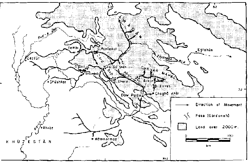
FIGURE 5-2 Bakhtiari pastoral
movements.
While there is general agreement about the nature of this summer
upslope, winter downslope movement, and while there is a consensus that movement
proceeds in a zigzag fashion utilizing valley bottoms and favorable passes, much
ambiguity still persists. De Bode provides a list of summer and winter
encampments that indicates that the Chehar-lang spend their summer near the
sources of the Zayandeh Rud in the Zard Kuh range as well as in the district of
Faradan (with minor groups in Chahar Mahal), while the Haft-lang spend their
summer in Chahar Mahal and near the sources of the Karun River in Zard Kuh. (18)
However, he fails to indicate the routes followed, aside from a cryptic comment
that a tendency to cross each other's path often leads to conflict between the
two groups. Coon asserts that there is only one practical route through the
Bakhtiari country and that the entire tribe, therefore, must move as a unit
along this route twice each year. (19) De Morgan also describes only one
Bakhtiari migration route (it crosses the Rud-e Dez by a bridge after descending
from the uplands via the pass at Badouch), but he gives no clear indication that
this is the only route utilized by the Bakhtiari. (20) In contrast, Cooper
states that there are five routes through the Bakhtiari mountains, (21) a number
cited by several other writers. Yet Cooper traveled only one of those routes,
the most rugged of the five, one that is used by only a small portion of
Bakhtiari, and his description of that route is too vague to permit positive
identification. Sawyer also mentions five ways across the mountains, but he only
specifies four - the God-e Murda (a pass that fails to appear on most maps of
the area) and Cherri passes on the two main roads from Shushtar to Esfahan, and
Gili Shah and Pambakal passes across Zard Kuh. (22)
Despite the confusion present in the literature as to which
routes are followed, some definite conclusions about migration tracks can be
ascertained. The most commonly mentioned route, used exclusively by the
Haft-lang, is the old caravan route from Ahvaz to Esfahan. (23) This trail,
called the Lynch Road, crosses the Rudkhaneh-e Jarrahi north of Ramhormoz,
passes over the outlying Zagros ranges, and descends to the Karun valley. After
cutting off a loop of the Karun, the road continues to Dow Polan where a split
occurs. Those groups summering in Chahar Mahal cross the Karun and proceed
westward to Chagha Khur before turning northward, entering Chahar Mahal via the
pass (gadang) at Zirreh. (24) The majority of the Haft-lang continue up the
Karun along the eastern slopes of Zard Kuh. In the upper reaches of the Karun
directly east of Gili Shah pass is a notch, the remnants of an ancient attempt
to divert the Karun into the headwaters of the Zayandeh Rud, where it is
relatively easy to cross the last mountain barrier. (25) Once across this range,
the Haft-lang are in the valley of the Zayandeh Rud, which offers an easy
passage to the summer pastures in Faradan.
The other major Haft-lang route (there may well be others
unknown to Europeans) traverses the central portion of the Bakhtiari area. (26)
This road leaves from the Shushtar area, crosses the Karun, and wends its way
along mountain valleys and across numerous passes to the tribal staging area in
the Shambar valley. From here, the trail crosses the gadang at Silili before
crossing Zard Kuh at either Pambakal or Gili Shah. (27) At this point, the
Bakhtiari from Shushtar join those proceeding up the Karun from Ramhormoz and
follow the course of the Zayandeh Rud to Faradan.
The Chahar-lang, the smaller and weaker of the two Bakhtiari
sections, begin their migration from around Dezful. Evidently, some of the
Chahar-lang follow the same route as do the Haft-lang from the Shushtar area,
since Cooper, who traveled with the Baba Ahmadi (a group that winters around
Dezful), passed through the Shambar valley on his way to Chahar Mahal. (28)
Other Haft-lang sections proceed either up the left bank of Rud-e Dez, and
thence through the headwaters of the Rud-e Shur via Tembi to the northwest flank
of Zard Kuh at Gardan Pambakal, or journey somewhat closer to the Karun through
Chilau and over the southern passes of the Zard Kuh. (29) Since the majority of
the Haft-lang summer in Faradan, their path crosses that of the Chahar-lang, the
majority of whom summer in Chahar Mahal, and disputes over the right-of-way
probably account for the mutual hostility of the two groups mentioned by de
Bode. Once across Zard Kuh, those sections going to Faradan follow the Haft-lang
route down the Zayandeh Rud, while the majority of the Chahar-lang enter Chahar
Mahal through the Alikuh pass over Kuh-e Saldaran. (30)
Once over the major mountain barriers, the Bakhtiari spread out
into their upland pastures. While some of the Bakhtiari clans are sedentary, the
majority are nomadic, and agriculture forms only a minor part of their economic
life. Despite this fact, it is not uncommon to find nomadic Bakhtiari sowing
wheat and barley in both their summer and winter quarters as a needed adjunct to
their pastoral activities. (31) Autumn and the onset of cooler temperatures
signals the return to lowland grazing and the clans retrace their steps
downslope over the same routes used in their ascent.
In conclusion, while information on the Bakhtiari is
surprisingly limited considering the former power and importance of the group,
enough data is available to indicate the nature and the pattern of their
migratory regime. Despite the impossibility of identifying which tribal clans
use which available routes and the difficulty in ascertaining the precise number
of routes that can be used, it is obvious that certain subsections follow
traditional paths. Cooper, for example, traveled with the Baba Ahmadi tribe over
the Zard Kuh range from the Jungari district in Khuzestan to Chahar Mahal, while
the Haft-lang are largely restricted in their migrations to the Karun River
basin. Because avenues of passage are limited to river valleys and mountain
passes, the movement is restricted to a limited number of possible routes and it
thus has a very definite and clear linear, constricted pattern on the map. This
strong linear pattern, coupled with a marked seasonal oscillation between summer
and winter pastures, characterizes all groups of mountain nomads.
NOTES
1. See Thomas R. Stauffer, "The Economics of Nomadism in Iran,"
Middle East Journal XIX:284-302 (1965). Fredrik Barth, "Nomadism in the Mountain
and Plateau Areas of South West Asia," in The Problems of the Arid Zone (Paris:
UNESCO, 1962), pp. 341-355, also argues that the nomad is often the best
possible exploiter of areas that are too marginal for agricultural use, unless
governments are ready to invest capital expenditures grossly disproportionate to
the possible returns.
2. The best general account of the physical characteristics of
the area is found in Theodore Oberlander, The Zagros Streams: A New
Interpretation of Transverse Drainage in an Orogenic Zone (Syracuse Geographical
Series No. 1; Syracuse: Syracuse University Press, 1965).
Also worthy of mention are the travel-oriented writings of: C.
J. Edmonds, "Luristan: Pish-i-kuh and Bala Gariveh," Geographical Journal
LIX:335-356 and 437-453 (1922); J. V. Harrison, "The Bakhtiari Country,
Southwestern Persia," Geographical Journal LXXX:193-210 (1932); F. R. Maunsell,
"The Land of Elam," Geographical Journal LXV:432-437 (1925); and H. A. Sawyer,
"The Bakhtiari Mountains and Upper Elam," Geographical Journal IV:481-505
(1894), all of which devote the major portion of their attention to a
description of the topography of the Zagros mountains.
3 For a detailed description of the vegetation of Iran, see Hans
Bobek, Die nat�rlichen W�lter und Geh�lzfluren Irans, (Bonner Geographische
Abhandlungen, Journal 8 (1951), and idem, "Klima und Landschaft Irans in vorund
fr�hgeschichtlicher Zeit," Geographischer Jahresbericht aus Osterreich XXV:42
(1953-1954). A more recent reconstruction of the original vegetation cover of
Iran is M. Zohary's "On the Geobotanical Structure of Iran," Bulletin of the
Research Council of Israel, Supplement to Volume 11D (1963).
4. M. H. Ganji, "The climate of Iran," Bulletin de la Soci�t� de
G�ographie d'Egypte XXVIII:195-299 (1956), has an excellent series of maps that
point out this pattern.
5. G. Demorgny, "Les reformes administratives en Perse: Les
tribus du Fars," Revue de Monde Musulman XXII 85-150 (1973), indicates just how
extensive such shifts can be, for he describes (p. 105) the Basseri as a tribe
of peaceful agriculturalists. His map (Carte No. 2, end-papers) demonstrates
that migrations also were once of much smaller amplitude than at present.
6. Fredrik Barth, "The Land Use Patterns of Migratory Tribes of
South Persia," Norsk Geografish Tidsskrift XVII:4 (1960).
7. Ibid., pp. 7-8.
8. Barth, Nomads of South Persia, pp. 4-6, is the best if not
the only, source on the Basseri migration pattern.
9. Ibid., pp. 6-7.
10. Ibid., p. 9.
11. See Clement de Bode, Travels in Luristan and Arabistan
(London: J. Madden and Co., 1845), p. 77, an invaluable source on southwest
Persia, as well as Harrison, "The Bakhtiari Country, Southwestern Persia," p.
193; Sawyer, "The Bakhtiari Mountains and Upper Elam," pp. 481-482; and Sir
Arnold T. Wilson, "The Bakhtiaris," Journal of the Royal Central Asin Society
X111:205-225 (1926). There is some confusion as to the precise boundaries of the
Bakhtiari area, but there is general agreement in placing the Bakhtiari between
the Lurs and the Qashqai. However, this is only partially true, for the Atlas
Narodov Mira, (Moscow: Glavnoe Upravelerie Geodezii, Kartografii, 1964). pp.
70-71, shows the Bakhtiari and Qashgai tribal territories adjoining in their
upland summer quarters, but being separated from each other in their lowland
winter quarters by a solid block of sedentary Lurs.
12. None of the written materials dealing with the Bakhtiari
give detailed data on the specific routes followed during a seasonal cycle. The
most striking example of this deficiency is the effort of Merian C. Cooper,
Grass (New York: G.P. Putnam's Sons, 1928). While Cooper's description of
Bakhtiari movement is graphic and his photography is excellent, he migrated with
only one minor group, mentions nothing on movements of other groups, draws no
maps, and seems to regard the specifics of place names and location as
non-essential information easily dispensed with. The best source for the
Bakhtiari remains the now dated work of Clement de Bode.
13. De Bode, Travels in Luristan and Arabistan pp. 82-83;
Wilson, "The Bakhtiaris," p. 208; and Cooper, Grass, pp. 9-10.
14. See Cooper, pp. 131-135, for a description of this winter
dispersion.
15. Wilson, "The Bakhtiaris," p. 208.
16. Cooper, Grass p. 195.
17. Ibid., p. 195.
18. Carleton S. Coon, Caravan: The Story of the Middle East (New
York: Holt, Rinehart and Winston, 1965), p. 219.
19. De Bode, Travels in Luristan and Arabistan p. 77.
20. Jacques de Morgan, Mission scientifique en Per&e (Paris:
E. Leroux, 1894-1904), II:200.
21. Cooper, Grass, p. 212.
22. Sawyer, The Bakhtiari Mountains and Upper Elam.
23. J. V. Harrison, "Some Routes in Southern Iran," Geographical
Journal XCIX:120, 122 (1942),; and Cooper, Grass, p. 41.
24. Sawyer, "The Bakhtiari Mountains and Upper Elam," map, end
papers.
25. Harrison, "Some Routes in Southern Iran," p. 126.
26. Harrison, "The Bakhtiari Country," pp. 194-199; and idem,
"Some Routes in Southern Iran," p. 125.
27. Harrison, "The Bakhtiari Country," p. 197.
28. Sawyer, "The Bakhtiari Mountains and Upper Elam," p. 493.
29. Cooper, Grass, p. 245.
30. Harrison, "Some Routes in Southern Iran," p. 216.
31. Sawyer, "The Bakhtiari Mountains and Upper Elam," map, end
papers.
32. Wilson, "The Bakhtiaris," p.
208.
The Marri Baluch of Pakistan
DOUGLAS J. JOHNSON
The Baluchi tribes, mingled with large numbers of culturally
akin Brahui, stretch over the vast, barren, underpopulated region known as
Baluchistan. Unfortunately the recipients of little detailed study, (1) the
Baluchi range far afield, some groups being reported as far north as the Harat
area. (2) The only systematic study was conducted by Pehrson, (3) who deals with
the Marri Baluch. This group dwells in a hilly, broken area at the northeast end
of the Baluchi-inhabited territory near the Afghanistan-Pakistan border, and is
separated from the main grouping of Baluchi tribes of Makran and Chagai and from
the Brahui tribes of Kalat by the non-Baluchi and non tribal areas of the Sibi
basin. North of the Marri area are found the Luni and Kakar Pathan
agriculturalists as well as the Afghani powindah nomads who occupy the northern
region during the winter. The Marri are cut off from direct access to the Indus
valley by the Khetrans, speakers of their own peculiar dialect, and are bound to
the south by the Bugti Baluch, traditional enemies of the
Marri.
Physical environment
While the Sibi basin and the Indus valley lowland are extremely
flat, featureless plains, the Marri area, a tangled mass of limestone hills and
narrow valleys, is a complete contrast. Except for the Sulaiman range, which has
a north-south axis and overlooks the Indus valley, the main trend of the ridges
is east-west. Valley bottoms and plateaus in the main Marri tribal area vary
from 800 to 1,000 m in elevation, while hill elevations gradually increase from
1,000 m in the south to over 3,000 m in the Pathan districts to the north.
Passes are few and widely scattered and passage from one valley to the next is
often a problem. The result is a confused drainage pattern, the east slopes of
the Sulaiman mountains draining directly to the Indus, whereas the remainder of
the surface runoff is discharged toward the southwest into the plains around
Sibi.
Most of these streams flow during no more than two months of the
year (July and August), and the seasonal nature of the stream flow is directly
related to the paucity of the region's precipitation. Rainfall totals are low,
averaging 75-125 mm in the lowlands, while totals as high as 300 mm have been
recorded under orographic conditions in the northern mountains. (5) Although
rain occasionally falls in winter - the result of very infrequent cyclonic
storms of low moisture content that drift in from the eastern Mediterranean -
the main rainfall occurs in July, August, and early September. Coming at the end
of the summer monsoon, this rain, sporadic in distribution and violent in
character, falls in the form of torrential thunder showers that give rise to
heavyflooding. Although streams flow only during part of the year, subsurface
water in streambeds is usually available with only a small amount of digging.
Not only is rainfall sporadic in distribution and sparse in
quantity, but it also occurs during the hottest part of the year, thus lessening
its effectiveness. Temperatures in excess of 50°C are not uncommon in the
Sibi plains during the summer. Highland temperatures tend to be cool in summer
and cold in winter, so that a marked daily and seasonal temperature range is
characteristic. The combination of high temperatures and low rainfall totals
produces a scanty vegetation cover, and vegetation, like temperature conditions,
tends to be distributed aptitudinally. (6) On the higher elevations are found
scattered stands of juniper, pistachio, ash, and wild almond, while acacias
(Acacia nilotica, A. modesta), olives, and occasional poplar (Populus
euphratica), (7) blue gum (Eucalyptus), and willow trees are found in the lower
hills. In the valleys, dwarf palm (Nannorrhops ritchieana), tamarisk (Tamarix
indica), Zizyphus nummularia, and occasional myrtle groves are common. Annual
grasses and herbs are scattered everywhere, and it is their fluorescence in late
spring and continued presence in summer, together with that of the trees and
shrubs, that give the area its best pastures.
(8)
Seasons and migrations
Early statements on the nature of the Baluchi-Brahui pastoral
system fail to deal with the question of seasonal migrations in concrete and
precise terms. Pottinger, for example, describes the Baluchi as being a pastoral
people who remain within a relatively restricted area. (9) On the other hand, he
believes the Brahui to be "a still more unsettled wandering nation, always
residing in one part of the country during the summer, and emigrating to another
for the winter season; they likewise change their immediate place of abode many
times every year in quest of pasturage for their flocks.” (10)
The Imperial Gazetteer is somewhat more specific about the
Brahui regime, suggesting that the movement from highland to lowlands and vice
versa was in part conditioned by a desire to escape temperature extremes and in
part by employment as seasonal agricultural workers at harvest time. (11)
Spooner foreshadowed an explanation when he suggested that upslope-downdope
movement was coupled to periodic visits to grain fields and date groves, as well
as to somewhat irregular movement of the household units and herds in response
to a varying pattern of rainfall distribution. (12) However, it was not until
the appearance of Pehrson's study of the Marri Baluch and Barth's continuation
of Pehrson's work (13) that an ecological explanation of an apparently vague,
complex, and seemingly random system was developed (figure
6-1).
A mixed economic system
Faced with a harsh, inhospitable, and marginal environment, the
Marri have evolved a complicated subsistence system that mixes a variety of
exploitive techniques that are difficult to combine in an attempt to maximize
returns. (14) As a result, Marri household units engage in herding, agriculture
(generally dry farming), wage labor, and collecting in proportions that vary
from group to group.
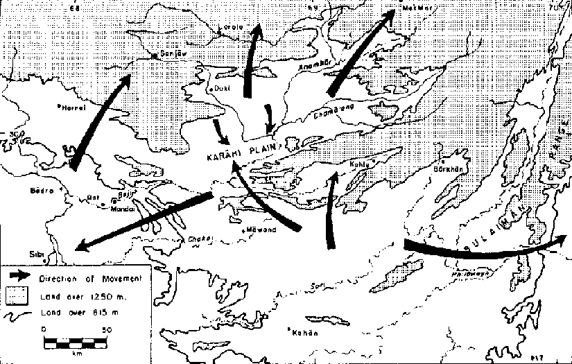
FIGURE 6-1 Marri Baluch migration
routes (after Barth, 1964).
Herding usually forms the most important activity, with a wide
variety of animals being kept. Sheep and goats are the most important animals
herded, their meat and wool being sold, but milk and other dairy products,
because of taboos against their sale to outsiders, are consumed within the
family. (15) Donkeys and camels are the major baggage animals, although the
rough and stony nature of the Marri tribal area is hard on camels and generally
restricts their possession to the rich, who keep their camel herds outside the
tribal area in the lowlands of Sind. Horses are kept by the wealthy as a
prestige symbol, while cows are retained only in sufficiently large quantities
to ensure an adequate supply of agricultural bullocks. The best pasture for
cattle and sheep is from April on into summer, while at other times all animals
must subsist on dry fodder. Water is often a problem, since sheep must be
watered three times a day in hot weather, and once a day in cool weather,
whereas goats must have water once a day in hot weather, and every other day
during the cool season.
Agriculture, almost exclusively dry-farming of barley and wheat,
also forms an important part of the Marri pattern. Whereas pasture land is the
collective possession of the tribe and thus open to use by any Marri, ownership
of agricultural land is vested in individual tribal sections. (16) Within the
tribal section, land is allotted on an equal basis to each male member,
regardless of age, for use during a 10year period. Since efforts are made to
ensure equality in land quality, these plots are scattered widely about the
Marri area. Moreover, as population increases, there is a definite tendency to
increase the amount of land devoted to agriculture, and at the same time to
encroach on the common pasture traditionally reserved for all Marri. This
withdrawal of agricultural land diminishes pastoral reserves and forces Marris,
all of whom want to retain a mixture of agriculture and animal husbandry in
order to balance their diet, to search for pasturage in areas outside the Marri
tribal territory. Thus, a slow but steady expansion into the Pathan areas to the
north has been taking place, abated by the superior military and social
organization of the Marri. (17)
The relative weight that a particular household unit assigns to
herding as opposed to agriculture determines the particular economy and degree
of mobility which that unit possesses. At one end of the continuum are the
sedentary populations, primarily concerned with dry farming (although they may
keep a few sheep and goats) and attached to a small number of towns and a
somewhat larger number of semipermanent agricultural villages, whose fortunes
fluctuate both with climate and with the success or failure of local political
leaders. (18) Grouped around each town or village is a varying number of darshin
nomads. These nomads move within a restricted area about 20 km in radius
centered on the village, and are kept within the local area by relatively small
herd size, a relatively large stake in village agriculture as wage laborers and
as farmers in their own right, and by their need for a market for their animal
products and a procurement center for trade goods. On the other end of the
continuum are the powindahs, relatively free-moving nomadic camps unattached to
a particular village. Marri nomadic camping units, whether darshin or powindah,
are small, scattered, and can range from one to eight families, but generally
number three to four. Powindahs are distinguished from darshin nomads by their
longer migrations and greater herd size, (19) but this distinction, as well as
the distinction between sedentary agriculturalist and darshin nomad, should not
be regarded as absolute. Loss of herds through disease or other natural
calamities, as well as the development of political and economic ties with a
village, can change a powindah into a darshin or a sedentary, just as an
increase in herd size may transform a darshin into a powindah. Thus, the
situation is not stable, but rather is dynamic, with a great deal of movement
from one group to another.
Another result of the different relative weight assigned to
agriculture and the varying requirements of the different species in the camp
herds is a marked spatial separation of the various camp functions. Since each
activity has its own optimal pattern and cycle of movement, individual members
of a camp will be scattered far and wide across the landscape. (20)
Because agricultural land is located in areas unsuited or
undesirable for grazing and because individuals may be assigned or may lease
land anywhere in the tribal territory, the men, who do most of the plowing and
agricultural work, will often be found for extended periods at great distances
from the camping unit. Care of the animals dominates the daily camp rhythm, and
because different species have different water and forage requirements and
preferences, they are herded separately. Shepherds are usually males, the young
men herding the adult sheep and goats in the higher hills and mountain ranges,
while young children guard the lambs and kids, usually keeping them near the
camp. Women, children, and old men are in charge of the cattle and donkeys.
Since the various herds leave the camp in the early morning, move through their
separate orbits during the day, and do not return until night, the camp is
largely deserted, particularly by the males, during the course of the day. Women
have various gathering tasks that take them from the immediate vicinity of the
camp, while the men of the camp are also often away buying and trading, hunting,
searching for new pastures, or attending to political responsibilities. With so
many activities of a disparate nature going on, the result is to "exert partly
conflicting pulls on those participating. Any migration policy will be a
compromise between these different pulls" (21) to be determined in the face of
imperfect knowledge of precipitation, labor markets, and political relations,
and only after a great deal of debate. In such a situation, despite the
regularizing limitations of habit and previous experience, much variation in
migratory movement at the camp level from year to year is to be expected and
does in fact occur. (22)
Coupled with the high degree of flexibility in and variability
of movement at the camp level is an apparently bewildering variety of movements
at the tribal level. (23) During the hot months of summer there is a general
northward shift toward higher elevations that brings Marri camps out of their
tribal territory and into the Pathan regions around Sanjawi, Loralai, and
Mekhtar. A similar movement north into the northwest Marri area or the southwest
Pathan area is undertaken by Marri groups who winter in the plains around Sibi.
However, at the same time there is a drift southward by camps in northern Marri
areas into the Kohlu valley and surrounding areas; this meets a contrasting
northward drift of camps from the extreme south. To further complicate the
pattern, there is also a summer movement of scattered camps southward into the
surrounding lowlands.
These apparently contradictory movements can best be explained
by a concept of niches. (24) The Marri, because of their mixed agricultural and
pastoral economy, are able to effectively occupy all of their niche, while they
are blocked in any directly southward movement by the Bugti, who practice an
identical mixed economy. To the north, the sedentary Pathan and nomadic
powindahs exploit two separate halves of the same niche. (25) Either because of
an inferior power position vis-�-vis the powindahs, or because of a desire to
establish a mutually symbiotic relationship with them, or because of lack of
inclination or opportunity, the northern sedentary Pathans keep few animals.
Thus, when the powindahs leave on their summer trek to central Afghanistan, a
niche is open for exploitation, and the Marri move in to fill it. Rent must be
paid to the Pathans for use of the grazing, but, since it is generally the
wealthier Marri with an almost exclusive emphasis on herding (the traditional
role of agriculture being frequently neglected among wealthy Marri with large
herds) who move in, the cost of grazing is not an insufferable burden. Since
they are able to use relatively abundant pasture during the year's best rainfall
in a zone having a cool temperature and a minimum of competition for pasture,
the arrangement is an advantageous one. With the arrival of winter, the
powindahs return from the north and reoccupy their winter quarters. Since the
Marri and the powindahs are traditional enemies and the Marri sheep are less
tolerant of cold than are those of the powindahs, the Marri are forced to fall
back on their tribal lands or to the Khetran lands around Karkhana. (26)
Movement east and southwest into Sind represents a symbiotic
response to the lowland agriculturalists' need for labor to harvest crops and
clean irrigation ditches. Although this offers an opportunity for Marri to earn
cash and increase their flocks in an area with few pastoralists, it interferes
with the Marri's own agricultural practices and so represents an alternative
largely restricted to the impoverished, who have small flocks and little seed.
(27) The seasonal migration of Marri groups from the hot Sind plains into the
Marri and Pathan highlands seems to represent a miniature powindah pattern; (28)
groups that occupy the central valley during summer adhere to the traditional
mixed agriculturalpastoral system, which means that long-distance movement
outside tribal territories would impose an intolerable burden in commuting to
their agricultural holdings. Finally, concentration in the central valleys is
reputed to be due to more reliable monsoon rain there. (29) However, if the
monsoon rains fail, these groups, as well as those that remain in the south near
Kahan, move south into the Sindhi plains where their more heat-resistant stock
has a better chance of survival and where water is available in poorly drained
areas and along irrigation
canals.
Conclusiones
The overall pattern of Marri pastoralism can be defined with
reasonable accuracy. It is a system that allows a great deal of flexibility both
at the camp level - to accommodate the different demands of a variety of animals
and scattered agricultural holdings - and at the tribal level, where a flexible
response to a sporadic rainfall and scattered pasture makes possible the
occupation of open ecological niches. The system is characterized by a general
lowland-to-highland movement in summer, although the movement to Sind and to the
central valleys complicates the picture. Despite the fact that data is not
available for the study of movements of individual camp units, it is reasonable
to suppose that movement of individual camping units would be fairly
constricted, since passage through the country is largely restricted to valley
bottoms and infrequent passes as the herding units oscillate between their
summer and winter pastures. While individual families from one clan may
participate in a variety of possible patterns, the system at the tribal level
remains one of rational and ordered utilization of the possibilities of the
environment.
NOTES
1. See, for example, the interesting, but uneven, general
historical survey of Muhammed Sardar Khan Baluch, Hi&tory of the Baluch Race
and Baluchistan (n.p.:n.d.). Also having some limited usefulness are works such
as Mansel L. Dames, The Baloch Race (London: Royal Asiatic Society, 1904), an
attempt to evaluate various theories about Baluchi origin and migrations and
reconcile them, as well as travel accounts such as Edward E. Oliver, Across the
Border, or Pathan and Biloch (London: Champman and Hall, 1890), or Henry
Pottinger, Travels in Beloochistan and Sinde (London: Longman, Hurst, Reea, Orme
and Brown, 1816). While excellent for background information, studies of this
type usually provide little of solid value to the scholar with particularized
interests. Even where detailed work exists, it is often so narrowly focused as
to provide little additional information. Instances of this type are Klaus
Ferdinand, "The Baluchiatan Barrel-Vaulted Tent and its Affinities," Tolk
1:27-50 (1959), a detailed study of the Baluchi tent, and Siro Kitamura ted.),
Plants of West Pakistan and Afghanistan (Kyoto, 1964), essentially a catalogue
of plants that lacks any reference to their potential utility for grazing or
other activities.
2. W. Ivanov, "Notes on the Ethnology of Khurasan," Geographical
Journal LVll:143-158 (1926), says a few words about the Baluchi nomads but does
not give enough information to even begin to work out the migration patterns of
these northern Baluch.
3. Robert N. Pehrson, The Social Organization of the Marri
Baluch (Viking Fund Publications in Anthropology No. 43; Fredrik Barth,
compiler; New York: Wenner-Gren Foundation for Anthropological Research, Inc.,
1965). The author lived with a small nomadic camp while doing 0a field work and
died in the field leaving 0a notes to be analyzed by Fredrik Barth. As a result,
the data is not quite as complete as it might otherwise have been, particularly
in regard to the detailed seasonal movements of the individual nomadic camp.
However, as the best available source, Pehrson'a study provides the basic
information for this case study.
4. Despite being now somewhat out of date, by far the best
source discussing the physical environment of the Marri continues to be the
"Baluchistan," Imperial Gazetteer of India (Calcutta: Superintendent of
Government Printing, 1908).
5. Ibid., p. 139.
6. See ibid., for perennial species and their distribution.
7. Ibid., p. 110.
8. Pehrson, Marrs Baluch, p. 1.
9. Pottinger, Travels in Beloochistan and Sinde, pp. 61-62.
10. Ibid., p. 70.
11. Imperial Gazetteer of India, "Baluchistan," p. 24.
12. Brian Spooner, "Kuch U Baluch and Ichtyophagi," Iran 11:63
(1964).
13. Fredrik Barth, "Competition and Symbiosis in North East
Baluchistan," Folk VI:15-22 (1964).
14. Pehrson, Marri Baluch, p. 5.
15. Ibid., p. 5.
16. Barth, "Competition and Symbiosis," p. 19.
17. Fredrik Barth, "Ethnic on the Pathan-Baluch Boundary,
Indo-Iranica (Festschrift Morgensterne) (Wiesbaden: Otto Harrassowitz, 1964),
pp. 13-20.
18. See Pehrson, Marri Baluch, pp. 11-12, for a more detailed
treatment of the various residence forms that characterize Marri society.
19. Pehrson (ibid., p. 14) suggests that when a herd reaches
about 100 animals, all other considerations become of secondary importance, and
the camp then detaches itself from any particular village in order to have
greater freedom to move in search of water and pasture.
20. Ibid., pp. 6-7 and 76-79.
21. Ibid., p. 77.
22. Ibid., p. 15.
23. Barth, "Competition and Symbiosis," pp. 15-22; and Pehrson,
Marri Baluch, pp. 15-16.
24. Barth (ibid., p. 17) argues that any particular environment
or niche offers a certain amount of exploitable organic energy. Because
exploitation of a niche is conditioned by the culture and technology that a
particular group can bring to bear, it is conceivable that a given culture will
not be able to use the full organic potential of its niche. Into the gap thus
created other groups may possibly move, until the full limit of that particular
niche is utilized. For a further example of this niche concept, see Fredrik
Barth, "Ecologic Relationships of Ethnic Groups in Swat, North Pakistan,"
American Anthropologist LVIIl:1079-1089 (1956); and Bruno Fautz, Sozialstruktur
und Bodennutzung in der Kulturlandechaft de. Swat (Nordweethimalaya), Gieseener
Geographische Schriften 3, 1963). Here the Kohistani transhumants are unable to
keep enough animals (due to severe winters and inadequate stabling and forage
during the winter months) to completely occupy all of the available high
mountain pasture during the summer. The Gujars, a nomadic group, are able to
take advantage of this situation and move up the river valley in a restricted
oscillatory pattern typical of the Zagros Mountain nomadism and spread out over
the upland meadows, thus utilizing a niche that otherwise would be neglected.
25. Barth, "Competition and Symbiosis," p. 18ff.
26. Pehrson, Marri Baluch, p. 16.
27. Barth, "Competition and Symbiosis,' p. 20.
28. Ibid., p. 21.
29. Ibid., p. 17.
30. Pehrson, Marri Baluch, p.
15.
Changing patterns of resource use in the Bedthi-Aghanashini valleys of Karnataka state, India
MADHAV
GADGIL
Introduction
Indian society is among the most heterogeneous in the world -
one in which hunter-gatherers and mechanized fishing trawlers, subsistence
agriculturists and commercial plantation owners, village blacksmiths and modern
steel mill workers live side by side. It is an agglomeration of tens of
thousands of endogamous castes, a significant proportion of which still pursue a
traditional hereditary pattern of subsistence, be it nomadic sheep grazing,
basket weaving, or shifting cultivation. Many others, especially from the
trading and priestly castes, have shifted to the modern sectors. This situation
has led to a great variety of demands on the natural resources of the land;
thus, the basket weavers need bamboo to weave mats, and industry needs bamboo as
a raw material for paper; the peasants want river valleys to grow rice, whereas
industry wants them to generate hydroelectric power. While these demands are
mounting, acute shortages are developing, resulting in a whole range of
adjustments, collusion, and conflicts over access to resources. I shall attempt
to illustrate these with the help of a case study from a hilly region of
peninsular India, where we have been working over the last decade (Prasad et
al., 1985). Much of the information recorded here is based on personal
observations and extensive interviews in the field over this
period.
The setting
The Locale
The hill chain of the Western Ghats runs just inland of the west
coast of India from the southern tip of the peninsula at 8°N all the way to
the Tapi River at 21°N. Towards its middle, between 14°N and
15°N, the coastline is at its narrowest, with spur hills running right up
to the sea. This part of the Western Ghats constitutes the Uttara Kannada
District (also known as North Canara) of the state of Karnataka, a tract of low
undulating hills rising up to 600 m, the level of the Peninsular Indian Plateau,
and sloping rather gently towards the west coast, over a broad stretch of 80 km.
The annual precipitation ranges from 2,000 mm to 5,000 mm and is largely
restricted to the months of June through October, the period of southwest
monsoon. The rivers of the tract are relatively short, with lengths of less than
100 km; they run westward from the hills to the Arabian Sea. They are in spate
during the monsoon, but have little water during the rest of the year; the
smaller streams run totally dry. In the middle of this region run two rivers -
Bedthi and Aghanashini; their contiguous catchment areas of about 2,000 km²
are the focus of this case study (Campbell, 1883).
Plant and Animal Life
The natural vegetation of the tract includes low mangrove forest
at the mouths of the Bedthi and Aghanashini rivers; evergreen forests grow on
the coast, the western face of the Western Ghats, and on the crestline with
annual precipitation of over 3,000 mm; a semi evergreen and moist deciduous
vegetation is found to the east of the crestline where precipitation reaches
about 2,000 mm. The evergreen forests are economically notable: many species
produce secondary chemical compounds of value including spices (pepper,
cinnamon, and nutmeg) and drugs (reserpine). They also harbor wild mango and
jackfruit trees. The evergreen trees have largely soft wood; the deciduous
trees, on the other hand, often produce excellent timber, including the famous
Canara teak.
The natural animal life is varied and abundant, and includes
elephant, the Indian bison, spotted deer, tiger, grey langur and bonnet macaque,
flying fox and flying squirrels, the great Indian hornbill, and peafowl (Prasad
et al., 1979). The fresh waters, the estuaries, and the sea also abound in fish,
prawns, and shellfish.
There are leeches, ticks, and mosquitoes as well, and much of
this tract was highly malarial until the disease was controlled shortly after
the Second World War (Gadgill and Mahlotra, 1982).
Agriculture
Cultivation of paddy in fields kept flooded with water during
the monsoon is the dominant form of agriculture in this tract, but there are
also coconut and arecanut (also known as betelnut) orchards. A special variety
of paddy is cultivated in the brackish waters in the estuaries, a form of
cultivation requiring little labor beyond broadcasting seed and harvesting
grain. The arecanut orchards in the hills are multistoried plantations with
pepper vines trained onto the arecanut trees and bananas - constituting a middle
canopy; cardamom forms the ground layer. Only occasionally are hill slopes
cultivated, and then usually with millet species such as Eleusine coracana. The
leached soils in this region of high rainfall are nutrient poor, and there is a
tradition of adding substantial quantities of organic manure in paddy fields as
well as in orchards. This manure consists of loppings of leaves from forest
shrubs and trees and dung of domestic livestock. The only cultivated lands to
which no such manure is applied are the estuarine lands; the river silt yearly
deposited on such lands is rich in nutrients.
Animal Husbandry
A few chickens are maintained by all meat-eating communities of
the tract. All of the farmers maintain a few cattle and often buffalos. These
largely serve to convert grass on which they graze into dung, used as organic
manure. The production of milk is quite low. There is also little demand for
animal power in paddy cultivation and coconut and arecanut orchards, nor is
there much use of bullock carts for transport due to the hilly nature of the
terrain. Only in recent years has goat keeping been introduced to this tract.
Havugalla, a nomadic community, uses donkeys as beasts of burden, and in earlier
days, some horses were used for
transport.
Human communities
Endogamous Caste Groups
As in much of India, the society consists of a large number of
endogamous caste groups. Members of any caste group almost always marry within
their own caste. Outside their caste group they have considerable economic
interaction but little social intercourse. Each caste has its own leadership
that resolves many of its internal conflicts and regulates its behavior. Each
caste has customarily been assigned a position in the social hierarchy, and
based on such position the castes have been divided into five varnas: Brahmins,
or priests; Kshatriyas, or warriors; Vaisyas, or traders and artisans; Shudras,
or peasants; and Panchamas, or untouchables. These varnas are, however, an
artificial construct, the genetic affinity generally being stronger among
different caste groups in the same locality, regardless of varna affiliation,
than among different caste groups assigned to the same varna. There is also
little social intercourse among different endogamous groups within the same
varna, this being strong only within a given endogamous group. The existence of
these castes is not restricted to those belonging to the Hindu religion; the
caste system has been retained by those converted to Islam and Christianity as
well (Karve, 1961).
Each sedentary caste group has its own compact settlement; a
village is thus a collection of several caste-based settlements, or clans. Any
village community is then made up of one or more clans. Members of a given clan
have great commonality in their pattern of resource use; traditionally, they
even cultivated land communally or participated in communal hunts. However,
different clans within a given village community may differ markedly in their
pattern of resource use. The sedentary clans would further differ markedly in
their pattern of nomadic endogamous caste groups in their resource use patterns.
Our estimate is that around 30 sedentary and 20 nomadic
endogamous groups occupy the region of 2,000 km² of interest to us. It is
sufficient for our purpose, however, to consider nine of these groups - one
nomadic and eight sedentary. Of these, Havugallas are nomadic hunter-gatherers,
Ambigas are fishermen, Halakkis have a broad subsistence pattern including
farming, Patagars and Naiks are farmers, Haviks are a priestly caste primarily
devoted to horticulture, Saraswats are a priestly caste involved in trading,
Moslem traders are a group engaged in maritime trade, and Acharis are carpenters
(Campbell, 1883).
Havugallas
Havugallas are nomadic people who travel in small bands of one
or two nuclear families accompanied by dogs and donkeys. They camp well outside
of villages for a few days at a time, hunting many animals including snakes and
monkeys that are taboo to all other communities of the area.
Ambigas
Ambigas have their settlements on estuaries and the sea coast
and own no land or livestock. They fish with nets in open waters with the help
of small boats.
Halakkis
Halakkis have the broadest subsistence pattern of all
communities. They hunt avidly for game birds, hare, and deer; they extensively
collect bivalves and oysters from the rivers and trap fish by using tidal flow;
they cultivate paddy in monsoon and vegetables in the summer; and they weave
mats from leaves of Pandanus. They maintain a small number of cattle and
undertake small-scale construction work. Their settlements are restricted to the
coastal tract.
Patagars
Patagars are restricted to the sides of the rivers on the coast
and are engaged in cultivating paddy on uplands as well as in the brackish
waters of estuaries. They maintain a good number of cattle. They also weave mats
from Cyperus reeds.
Naiks
Naiks are largely restricted to broader upland valleys where
they practice paddy cultivation. They maintain a good number of cattle and
indulge in hunting game birds and larger mammals.
Haviks
Haviks are a priestly caste supposedly brought to the region in
medieval times to transfer worship of the temple at Gokarna away from a
nonpriestly group. Many families are still priests with little land holdings;
others have raised arecanut orchards on the coast as well as in the valleys up
the hills. They maintain large numbers of cattle and consume milk products
extensively. They are strict vegetarians and traditionally do not hunt or fish
at all.
Saraswats
Saraswats are a priestly caste widely distributed on the coast
and on the hills engaged in trade and moneylending. Under British rule they came
to own extensive lands. Unlike Haviks, they did not cultivate land themselves
but let it out to the tenants. Saraswats are among the few priestly castes that
consume fish and shellfish; traditionally, they do not eat any other meat.
Moslem Traders
Moslem traders are descendants of mixed marriages between Arab
traders and locals who do not practice cultivation or animal husbandry but who
specialize in maritime and other trade. They consume both fish and meat.
Acharis
Acharis are carpenters who traditionally worked for an inherited
clientele in one or more villages on a jajmoni basis. That is, they were paid in
kind a certain proportion of the other families' produce every year for looking
after those families' needs for carpentry. They do not cultivate or keep
animals. They eat fish and
meat.
Traditional patterns of resource management
The System
In the pre-Colonial period, Indian society had evolved an
interesting pattern to regulate competition over resources. The villages were
made up of populations of several endogamous caste groups knit together in a web
of mutual dependency. Each caste group had a specific, hereditary, and often
exclusive function assigned to it. Thus, any given Achari household had the
exclusive responsibility for carpentry operations for certain village
households, or a given
Ambiga household for supply of fish to certain other village
households. In turn, farming households provided a defined proportion of their
farm produce to the Achari or Ambiga households who served them. The village
community as a whole also provided a portion of their produce to the king as
tax.
The cultivated land was often owned communally by each clan -
all households of a given caste group in the village. The king, in theory, owned
all uncultivated lands and waters and had the right to assign a portion of it
for cultivation. The village community, however, effectively controlled all
these resources, which were partitioned in a way that assigned monopoly rights
over certain resources to a particular clan. Thus, only Halakkis collected
bivalves and only Ambigas fished open waters. There were further regulations in
the use of resources such as timber or fuelwood that were required by all clans
of the village and gathered from uncultivated lands controlled by the village
community as a whole.
This was, then, a system producing only low levels of surplus
for the ruling elite and with extensive communal management of resources based
on socially accepted customs and conventions. It probably permitted sustainable
use of the resource base that served a village community (Gadgil and Malhotra,
1983; Gadgil,
1985).
Colonial period
The Colonial System
In establishing their hold over India, the British sought to
convert the prevalent pattern of resource use (that generated little surplus for
the state and was based on strong communal regulation) into a pattern that would
generate higher levels of surplus for the state with resources under its firm
control. By the time of conquest, the British society had rejected communal and
customary modes of resource control. The British rulers imposed this system in
India, insisting that the only legitimate forms of resource control were through
individual and state ownership, and that all resource use should be fully
codified. All cultivated land was therefore to be individually owned, with the
owners responsible for paying a certain level of taxation in cash. All other
land and waters were to be state property, and to be utilized as far as possible
for generating resources of value to the British economy. In this hilly and
forested district with excellent natural growth of teak in the moist, deciduous
forest zone, the attempt was to convert as much of the uncultivated land as
possible into state-owned teak plantations. A certain amount of uncultivated
land was permitted, however, to generate resources for the local population,
although its ownership and ultimate control was firmly vested in the state
authority (Gadgil et al., 1983).
The principal consequence of this policy was near total loss of
control over resources by the nonliterate communities such as Halakkis,
Patagars, and Naiks. With the insistence on individual ownership of land and
payment of taxes in cash, these communities quickly ran into debt and lost the
ownership of land to the two literate, priestly castes, Saraswats and Haviks,
who could adapt to the new system of codified control of resources. While a
certain amount of resources of uncultivated land continued to be available to
the local population, this was as a privilege; their management rights were
removed. Good communal management of these resources, therefore, began to break
down, especially as the population began to increase with control of epidemic
diseases. The result was the unsustainable utilization of resources and their
decimation. There was little possibility at this stage of generating any surplus
from aquatic resources, which were left alone. However, there was siltation and
shallowing of the west coast rivers, which may have affected the aquatic life.
Reserved Forests
About half the uncultivated land of the region, amounting to 40
percent of the total land, was constituted into reserved forests under full
control of the state. The British were primarily interested in the production of
teak from these forests, and extensive tracts, especially in the moist,
deciduous forest zone, were converted to teak plantations under protest from
local populations, who valued the natural mixed forests (Dhareshwar, 1941). The
local people retained certain privileges of use of even the reserved forests,
including grazing in natural forests and older plantations and collection of
dead and fallen wood, generally under payment of some charge. Hunting was
continued, and elephants became part of the game. With the introduction of
firearms, many of the British and Indian government officials became avid
hunters. Another interesting development was that some of the Saraswat and Havik
landowners, albeit belonging to priestly castes, also took to hunting with the
help of firearms.
Sacred Groves
The sacred groves were strictly protected patches of forests
that were only occasionally utilized in times of distress. Consequently, they
had some of the beat preserved natural vegetation. The British attitude towards
these groves is well expressed in the following quotation from Buchanan, one of
the earliest British chroniclers of Peninsular India:
The forests are the property of the gods of the villages in
which they are situated, and the trees ought not to be cut without having
obtained leave from the . . . priest to the temple of the village god. The idol
receives nothing for granting this permission; but the neglect of the ceremony
of asking his leave brings vengeance on the guilty person. This seems,
therefore, merely a contrivance to prevent the government from claiming the
property. (Buchanan 1802; reprinted 1956).
All the groves on communal land were taken by the state as
reserved forests, leaving those in the midst of cultivated land under private
control. In this tract, the sacred groves taken over were constituted as
so-called "green forests" from which people were authorized to remove only dead
and fallen wood. These groves retained well-preserved tree cover throughout the
colonial period.
Minor Forest
Roughly half the uncultivated land was put under the control of
the land revenue authorities of the government and constituted either as minor
forest or as leaf manure forest land. The entire local community had full access
to the minor forest land for meeting their fuelwood, grazing, and leaf manure
requirements without payment of any charges. This right included the cutting of
live wood. With no communal management, the minor forests were overutilized and
depleted in many areas.
Panchayat Forests
A few pockets of minor forest land continued under the control
of local communities, which constituted a council or panchayat for their
management. With continuing control by village communities, many such panchayat
forests were managed in a sustainable fashion and retained good forest stock
throughout the British period.
Leaf Manure Forests
In the pre-British period, the arecanut orchard owners claimed
rights, either individually or as a clan, over forest tracts immediately
adjacent to their orchards. This right of ownership was not conceded by the
British government, and this land was taken over as land under ownership of land
revenue authorities. Nevertheless, the orchard owners were conceded extensive
privileges of free grazing and fuel and leaf manure collection from these lands.
They were also permitted to extract some timber from the leaf manure land on
payment of charges provided that a minimum density of 100 trees per hectare was
maintained.
After independence
The New System
There had been a vigorous debate during the independence
struggle over the kind of society and economy that the country should strive for
on achieving independence. Mahatma Gandhi had advocated the restoration of a
self-reliant and largely self-sufficient village economy. This would have
implied strong communal control over the common property resources. Mahatma
Gandhi was also against industrialization on the western model. On the other
hand, Jawaharlal Nehru, the first prime minister of independent India, favored
vigorous pursuit of modernization and industrialization. He also favored
centralized planning on the Soviet model, albeit in the context of a mixed
economy. Nehru's point of view largely carried the day, especially as it
coincided with the interests of the business and the urban literate classes who
have dominated the policies since independence. As implemented, this policy has
resulted in state sponsorship of heavy industry and power and irrigation
projects, leaving other sectors largely in private hands. Resources were made
available to the private and public industrial sector at highly subsidized rates
to promote their growth. Forest-based industry thus was assured a supply of
forest raw materials on a long-term basis at throwaway prices. These policies
meant that demands on the resources of the uncultivated lands and waters of the
country were substantially stepped up. This generated pressures for further
alienation of the local rural population from access to these resources. For
instance, there were moves to take over minor forests to raise industrial
plantations, and many rivers have been converted into dumps for chemical wastes
instead of sites of fish production.
At the same time, there have been measures to win over the rural
population-the major voting blocks. The agriculturists have been provided
irrigation and fertilizers at highly subsidized prices, and ownership of land
has been largely restored to the cultivators, certainly in the
Bedthi-Aghanashini region. However, the initial attempts to restore communal
organization and management of resources (such as community development
programs) have been declared failures and abandoned. The cooperative movement in
the rural areas has also been discredited. Thus, the new organizations of urban
literate classes and the business community and the bureaucracy and business
corporations have grown stronger, while those of the rural masses have little
clout left. This has enabled the industry and the bureaucracy that shares its
interests to divert the resources of the uncultivated lands and waters to its
own ends. The bulk of the rural population is, however, quite dissatisfied with
this situation, and hence unwilling to cooperate in good management of resources
towards this new objective. The result has been further rapid degradation of the
common property resource base since independence (Gadgil and Malhotra 1985;
Centre for Science and Environment, 1985).
Aquatic Resources
The Aghanashini remains one of the few unpolluted rivers of
India, and its estuary is still productive of fish and shellfish, which are
harvested by Ambigas and Halakkis. However, a significant new element has been
added in the form of development of fish and prawn cold storage and canning
facilities coupled to the export of prawns. This has considerably raised the
value, especially of bigger prawns, and has generated a vigorous commercial
market. The two trading castes of the region, Saraswats and Moslem traders, have
taken advantage of these new developments, and become active in both trade and
processing.
Uncultivated Lands
The level of harvest from these lands has been substantially
stepped up to meet the escalating needs of both industry and the increasing
rural population. The result of this nonsustainable use has been a rapid decline
in the plant biomass cover of such lands. The reserved forests, sacred groves,
minor forests, panchayat forests, and leaf manure forests have all undergone
such depletion to varying extents. In reserved forests, there has been an
accelerating pace of clear felling of natural plantations for raising not only
teak, but Eucalyptus plantations as well. There has been vociferous protest
against Eucalyptus plantations from farmers who believe that the runoff from
these plantations affects their crop yields. The local taboos against the
violation of sacred groves have rapidly disappeared since independence,
resulting in accelerating exploitation of many of them. Minor forests have
suffered most severely with unchecked fellings by local communities and many
others. In Masur, one of the villages where we have been working, for instance,
the local leaders of the Patagar and Halakki communities did make an attempt to
impose some social restraint on fellings from minor forests, but were rebuffed
by their own women.
Panchayat and leaf manure forests are two categories of forests
with some continuing tradition of management by local communities, clans, or
individual households. Many of these, too, have been overexploited, although
others are well managed and retain good plant cover. However, bureaucracy has
attempted to take over many of these, and the resulting uncertain atmosphere has
led to indiscriminate fellings in many panchayat and leaf manure forests. For
instance, there are two panchayat forests close to the town of Kumta. The
government served notice on both for takeover as reserve forest. One of the
panchayats has contested this in court; this forest is still fairly intact. The
other panchayat agreed to the takeover; within a few months, the forest had been
totally destroyed by the local
residents.
Recent trends
The System
The pace of nonsustainable utilization and consequent
degradation of the resource base of waters and uncultivated land has by now
reached a magnitude serious enought to compel response from all segments of the
society. The response of the Ambigas, Halakkis, Patagars, Naiks, and Havugallas,
the still largely illiterate communities being further and further impoverished
has been to abandon whatever traditions of social restraints on overuse of
resources that they still retain. The business communities have continued to
prosper in the process of liquidation of the capital of the natural resource
base, and their response has been a defense of the existing system. The urban
literate classes in the professions and bureaucracy are, however, beginning to
question the existing system and propound the need for a new order that lead to
sustainable resource use. Wherever there is an element of such a literate class
in the rural population, they, too, have called for new initiatives. Three such
responses are worth further consideration here.
Forestry Sector
The forestry system has so far been dedicated to eliminating all
privileges enjoyed by the rural population and to serving the interests of the
urban-industrial sector. A significant minority, however, is questioning this
approach and attempting to inject new ways of managing the uncultivated lands to
generate resources for the rural population. This has led to the development of
the so-called social forestry programs and, very recently, the establishment of
a national wasteland development board, which, in turn, has led to the
afforestation, for the first time, of minor forest lands in the
BedthiAghanashini valleys, beginning in 1984. This afforestation has been
supported by some of the more properous and literate Havik farmers, but many
others have opposed it. Nevertheless, there is growing acceptance of such
programs both within the forestry establishment and by the local population.
Another remarkable innovation of the foresters has been the planting of several
new "sacred groves" near major temples of the Bedthi-Aghanashini valleys.
Appiko Agitation
Some of the younger Havik farmers have organized a campaign
against the policies of the forest department, deriving inspiration from the
leadership of Sunderlal Bahuguna of the Chipko agitation in the Himalayas
(Centre for Science and Environment, 1985). They have called for a complete
cessation of all felling in reserve forests. The forest bureaucracy has
responded by attempting to drive a wedge between the literate, priestly caste of
Haviks and the illiterate, poorer castes, such as Naiks, by pointing to the
extraordinary privileges of leaf manure forests enjoyed by the Haviks alone. The
agitation has enjoyed a few successes in fits and starts - some fellings have
been stopped - but has not acquired any broader support.
Ecodevelopment Movement
Some of the other younger Havik farmers seriously committed to
bringing in new technologies to their calling have taken a managerial approach.
They have insisted on better management of all uncultivated land, including the
leaf manure forests, under their own control. They have joined with elements
from scientific and technical communities, including this author, to promote
more careful harvest from leaf manure forests, control of grazing, replanting of
the degraded leaf manure and minor forest lands, and so on. Initially, this
movement startedexclusively with the more properous Havik farmers. However,
realizing the importance of broadening the base of the movement, it is now
actively attempting to include Halakkis, Patgars, Naiks, and others in its fold
(Prasad et al.,
1985).
References
Buchanan, F. 1956. Journey Through the Northern Parts of Kanara
1801-2. Nagarika Printers, Kawar, India.
Campbell, J. M. 1883. Bombay Gazetteer: Kanara. Government
Central Press, Bombay, India.
Centre for Science and Environment. 1985. The State of India's
Environment 1984-85: The Second Citizen's Report. Centre for Science and
Environment, New Delhi, India.
Dhareswar, S. S. 1941. The denuded condition of the minor forest
in Kanara coastal tracts: its history and a scheme for its regeneration.. Indian
Forester 67:68-81.
Gadgil, M., and K. C. Malhotra. 1982. Ecology of a pastoral
caste: Gavli Dhangars of peninsular India. Human Ecology 10(1)107-143.
Gadgil, M., and K. C. Malhotra. 1983. Adaptive significance of
the Indian caste system: an ecological perspective. Annals of Human Biology
10:465-484.
Gadgil, M., S. N. Prasad, and R. Ali. 1983. Forest management in
India: a critical review. Social Action 33:127-155.
Gadgil, M., and K. C. Malhotra. 1985. Ecology is for the people.
South Asian Anthropologist 6(1)1-14.
Gadgil, M. 1985. Social restraints on resource utilization: the
Indian experience. Pg. 135-154 in: Culture and Conservation The Human Dimension
in Environmental Planning. Croom Helm, London, England.
Karve, I. 1961. Hindu Society: an Interpretation. Decan College,
Pune, India.
Prasad, S. N., P. V. K. Nair, H. C. Sharatchandra, and M.
Gadgil. 1979. On factors governing the distribution of wild mammals in
Karnataka. Journal of Bombay National History Society 75(3):718-742.
Prasad, S. N., M. S. Hedge, M. Gadgil, and K. M. Hedge. 1985. An
experiment in eco-development in Uttara Kannada District of Karnataka. "South
Asian Anthropologist
6(1):73-83.
Kenya: Seeking remedies for desert encroachment
H. F.
LAMPREY
Introduction
The immediate causes of desertification in the arid zone of
northeast Africa and the Sahel are overgrazing and woodland felling. A number of
underlying, indirect causes, however, result from the difficulties of
reconciling traditional nomadic pastoralism with modern influences, and the
expanding human and livestock populations. The author, formerly the project
coordinator for the Integrated Project in Arid Lands (IPAL) program of research
in northern Kenya - a regional project intended to obtain results widely
applicable in the African arid zone - is attempting to solve some of the
ecological and socioeconomic problems associated with desert encroachment.
The IPAL program was established as a pilot operation to
initiate research into the causes and effects of desert encroachment in a
subdesert region: one inhabited by nomadic pastoralists, where a money economy
has yet to replace the ancient livestock economy. The main purpose of the
project is scientific inquiry by a multidisciplinary team into the deleterious
changes taking place in this arid-zone ecosystem. There is also an important
second objective - that of seeking practical modifications and alternatives to
the traditional livestock-based economy, which might enable the degraded grazing
lands to be rehabilitated.
The broad scope of the problems associated with desert
encroachment and its control has become increasingly apparent to the scientists
engaged in the project during the last few years. Overgrazing and excessive tree
felling are the most immediate and obvious causes of desertification in
northeastern Africa, but the degradation of enormous areas of grazing land and
woodland in dry tropical Africa can also be attributed to the underlying
administrative and socioeconomic factors associated with such regions of low
economic potential. Some of these factors are shown diagrammatically in figure
8-1.
Field work started in 1976, and has been carried out mainly in
the subdesert country of northern Kenya, between Lake Turkana (Rudolf) in the
west and Mount Marsabit in the east (figure 8-2), a study area of 22,500
km² mostly about 500 m above sea level; preparatory reconnaissances have
been made in Sudan and Tunisia. In Tunisia, another program of arid-zone
research, following the IPAL pattern, has recently been started by
UNESCO.
Background
More than half the land surface of Kenya is arid or semiarid
rangeland occupied by traditionally nomadic pastoralists of several tribal
groups. Like tribes living elsewhere in northeastern Africa and the Sahelian
zone, they subsist almost entirely upon their herds. But unlike the greater part
of the Sahel, there is virtually no arid-zone agriculture in Kenya, and
consequently there is little of the interdependence between agriculturists and
pastoralists that is characteristic of the Sahelian zone. The small amount of
grain food consumed by the pastoralists in northern Kenya is brought into the
region from outside.
The overwhelming problem of the arid regions of northeastern
Africa and the Sahel alike is the apparent incapacity of the land to support, on
a sustained-yield basis, the numbers of domestic animals owned by the
pastoralists and, in many cases, needed for their subsistence. Overexploitation
- first of the grasses and other vegetation, followed by the trees and shrubs -
with concurrent soil erosion, compaction, and dessication, is causing a decline
towards desert conditions over large areas. The result is a reduction in the
capacity of the land to support the numbers of people who occupy it. The problem
is aggravated by population growth, which in northern Kenya is running at 2
percent.

FIGURE 8-1 Area in northern Kenya of
the IPAL study.
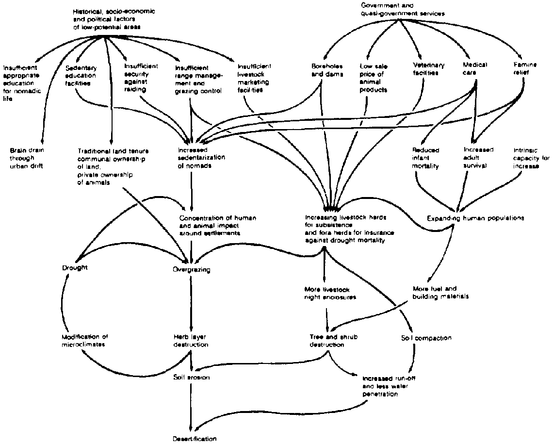
FIGURE 8-2 Some of the factors
causing desert encroachment in northern Kenya. (Reproduced from Nature and.
Resources, 14,4,1978)
Water Supplies
The main cause of the degradation is the new trend towards
settlement in the traditionally nomadic tribes. Centers of human and livestock
concentration have arisen and have expanded rapidly around the few springs and
wells, but especially near recently installed boreholes. Although fresh water is
the main attraction for such concentrations, shops, schools, medical centers,
and famine relief centers are additional incentives to settle.
Of equal importance is the protection that the villages, many
with small police posts, offer against intertribal raiding. Lack of security
over large tracts of land is a major reason for avoiding them and for the gross
overexploitation of the more secure areas. Each concentration area becomes a
nucleus of denuded land, from which the degradation spreads in widening circles'
as the people are obliged to go further for grazing and for the wood they need
for both fuel and livestock fencing. Localized desertification appears to be
gaining pace as a growing proportion of the pastoral population becomes settled.
In each dry season, and also through more prolonged droughts,
such as that of 1968 to 1976, there is an almost total dependence upon the few
perennial water supplies, and the destructive effects of the concentration are
most marked. During and immediately after the rains, the traditional dispersal
of nomadic families takes place as they move into areas where rain has fallen
and new growth has appeared.
This dispersal still occurs, although on a much reduced scale,
and an increasing proportion of the population, especially the women and
children and the older men, remains close to the villages, keeping their milch
animals with them. The young men continue to move out into the surrounding
country, taking the unproductive animals (known as the fore herds), males,
castrates, and barren females, following traditional nomadic practices.
Fora Herds
The fore herds serve as insurance against drought and other
misfortunes, including theft and death from disease. In favorable years, they
may appear to be a large surplus stock of unproductive animals that contribute
to the depletion of the vegetation. It is questionable, however, whether their
reduction would significantly lessen the rate of desert encroachment, for they
are mobile and widely dispersed and appear to have relatively little impact on
the vegetation.
Excessive Stocking Rate
Among the inescapable constraints to the management and the
desired diversification of land use in this region is the dry and variable
climate. With a mean annual rainfall of less than 150 mm, sustained agriculture
is not possible over the greater part of the region; animal husbandry will
inevitably remain the basis for the economy. In a purely pastoral society, in
which a minimal subsistence herd for a group of six to eight people is about 50
cattle (or their productive equivalent in sheep and goats or camels), it can be
calculated that about 1,200 kg liveweight of domestic stock (5 cattle, 2.5
camels, or 25 sheep and goats) is necessary to supply one person.
The project study area contains some 30,000 people who are
supported by about 36,000,000 kg liveweight of domestic stock. Although this
implies a stocking level barely sufficient for the subsistence of the human
population, it is evident that, under current pastoral regimes - and more
particularly in view of the increasing tendency of traditional nomads to settle
- the long-term carrying capacity of large areas of savanna rangeland is being
greatly exceeded.
During years of favorable rainfall (as in 1977 and 1978), there
may be a temporary abundance of animal fodder, with a resulting increase in the
herds. This leads to overstocking in subsequent dry years when plant production
is greatly reduced. Prolonged drought inevitably causes high mortality in the
herds, but by the time this happens considerable damage will have been done to
the
vegetation.
Traditional pastoralism
No system yet exists in the region for the management of
grazing. Traditional land tenure among pastoral tribes ensures communal
ownership of the grazing resources within each tribal area, although there is
individual ownership of livestock. It is not surprising, therefore, that nobody
takes responsibility for the maintenance of the pastures and the uncontrolled
competition for the limited grazing.
Although many pastoralists see the need to reduce stocking
rates, substantial culling of their herds is very unlikely for several reasons.
Under their existing economy, the majority of the families are already at or
near the subsistence level and cannot afford to reduce their herds. The more
prosperous families are reluctant to reduce their stock, which represents not
only their livelihood, but capital, insurance, and prestige as well. And in this
region the prices offered to the pastoralists are commonly too low to persuade
them to sell many animals during times of abundance.
Despite the clear disadvantage in the present livestock economy,
the traditional animal husbandry practiced by the Gabra and Rendille
pastoralists of northern Kenya is, in most respects, efficient and well adapted
to the harsh and variable climate and to the subdesert conditions. In any
attempt to rationalize land use in the region, traditional practices and skills
should not be discouraged, except where they are shown to contribute to
environmental damage.
Drought periodically causes famine after a large number of
animals have died. With the return of favorable conditions, many families have
been left without livestock and have become destitute, dependent upon the
continued supply of famine-relief food. Such people tend to increase the
unproductive sedentary populations and appear to lose their will to return to a
nomadic
life.
Baseline studies
It is against this background of socioeconomic difficulties that
IPAL is looking for the means to achieve ecological and social rehabilitation.
There can be little doubt that far-reaching changes in land-use policy will be
necessary. Range management alone will necessitate a degree of control that may
fail if it is not supported by the willing involvement of the pastoralists. The
project's approach to impending land reform, designed to arrest desert
encroachment, has been to gain the support of the people through public
relations activities.
The first task of the project has been to make an inventory of
basic information on the climate, soils, water distribution, vegetation,
wildlife, and domestic livestock, and on human populations and their economic,
social, and cultural characteristics. Vegetation and soil maps have been
prepared; a preliminary analysis of the climate has been made on the basis of
past records from the region; and meteorological observations from a network of
stations and rain gauges have been set up for the project. In addition to its
aridity, the most important feature of the climate is its variability: between
1968 and 1980, the annual rainfall has ranged from 50 mm to nearly 400 mm in the
subdesert
areas.
Vegetation and livestock
The main focus of the research program is the interaction
between the pastoralists and their livestock on the one hand, and the vegetation
on the other. The capacity of the pastures and woodlands to support livestock
depends on the sustainable production of the vegetation. Plant production is
closely correlated with rainfall, and the fluctuating climate results in highly
variable production from year to year and, due to spatial irregularity as well,
to localized variation.
Primary production is measured by the systematic sample clipping
of herb and dwarf shrub vegetation, to simulate grazing and browsing. Basic
production is expressed as dry weight per unit area and is related to recent
rainfall and to other characteristics of the site, including topography,
drainage, soil type, and history of use. The measurement of tree and shrub
production is considerably more difficult but will be undertaken as well.
Livestock food preferences and food-intake measurements have
been obtained in fenced plots where the stocking rates of camels, sheep, and
goats could be controlled. By simulating various livestock densities, the
effects of grazing at different intensities could be observed, and it was
possible to make preliminary estimates of the short-term impact and the carrying
capacity of the vegetation type being studied, and under the prevailing climatic
conditions.
In the region as a whole, livestock numbers and distribution
have been assessed periodically from the air. Ten surveys carried out in both
the dry and the wet seasons have shown that at least 20 percent of the study
area is heavily overstocked when judged by widely accepted range management
standards, and from the results of the project's stocking trials. As would be
expected, the overstocked areas are those surrounding the settlements, but they
frequently extend out from village centers as much as 30 km and can only be
described as deserts.
In close association with the studies on plant productivity and
the impact of animals, the project is studying several aspects of the ecology
and management of livestock, with the objective of understanding the
quantitative relationships of the herds both with their food resources and with
the human populations that depend on them. Useful results have been obtained on
the productivity of camel, sheep, goat, and cattle populations..including
population dynamics, growth and weight gain, milk production, and potential for
meat production. Diet and water intake in relation to seasonal changes and
availability are being studied.
It is evident from this experience with experimental herds that
animal production is markedly affected by disease and parasites. Preliminary
disease.control trials have shown that, despite the generally high levels of
resistance in indigenous livestock, growth rates and milk production are greatly
improved by minimal treatment for a small number of diseases. This holds out
hope that badly needed increases in animal production might be achieved
economically without further increase in animal
numbers.
Directions for the future
When IPAL eventually makes recommendations on livestock and
range management methods that will be consistent with the rehabilitation of the
vegetation, it seems probable that the management guidelines will be based very
largely on rational modifications to the traditional methods of animal husbandry
now practiced by the nomadic pastoralists.
Before any attempt can be made to plan such modifications
(possibly including improved breeding, the introduction of controlled grazing,
the controlled use of available water, obligatory selective culling of herds,
and the introduction of animal product marketing), it is essential to gain an
understanding of the traditional animal husbandry regimes in the region. For
this reason, an important component of the project is a study of traditional
livestock management methods and their relevance to modern techniques, designed
to optimize both the productivity and the conservation of the
rangelands.
The hema system in the Arabian peninsula
BY OMAR DRAZ
The Arabian hema (plural ahmia) grazing system, one of the
world's oldest effective range-conservation systems, can be used by individuals,
tribes, or governments. A survey in Saudia Arabia (19621966) of historic ahmia,
such as Hema Hail, Hema al Hourma, and Hema al-Ra'bza (rainfall under 150 mm),
which were formerly administered by the government, showed that these lands were
opened to free grazing by decree in 1953. Today it is difficult to see any
difference between the vegetation on these government reserves and adjoining
lands because of the effects of destructive grazing and the uncontrolled cutting
of trees and shrubs. By contrast, tribal or personal ahmias that had been
properly managed retained satisfactory levels of productivity, underscoring the
suitability of this system within the context of the local environment.
AHMIA IN ISLAM
The Prophet Muhammad was concerned with fodder reserves because
they preserved the strength of the Islamic nation. He protected Hema Alnaquia (a
wadi near Medina that was used mainly by animals) to defend the cause of Islam,
and is known to have said: "Hema is only for God and His Prophet." Evidently
this has been interpreted to mean that a governor or an Islamic state is allowed
to protect the ahmia in the best interests of the community.
Al-Iman al-Shafi'y (ninth century) stated that during
pre-Islamic days, a Sharaf-al-koom (influential person), upon arriving in a
village, would mark the boundary of his grazing land by the distance one could
hear a dog bark. In addition to this area for his personal use, he also enjoyed
the privilege of the surrounding lands grazed by others.
This extremely unfair practice, according to al-Imam al-Shafi'y,
was the system practiced by the Jahilia (pre-Islamic or unenlightened people).
It was subsequently corrected in accordance with the saying of the prophet,
"Muslim people are partners in water, fire, and ephemeral range."
The Hema al-Ra'bza, near Dari'ya in Saudi Arabia, is the pasture
preserve once protected by 'Umar ibnal-Khattab, the second caliph. The length of
the hema was about 250 km. A geographic Arabic dictionary, Mo'gam ma ista'gam,
revealed that during the time of 'Uthman, the third caliph, this hema was
expanded and the number of grazing animals (mainly camels and horses) increased
to 40,000.
'Umar ibn 'abd Aziz (seventh century), one of the most capable
caliphs of the early days of Islam, is known to have been very strict in keeping
the hema protected. Cutting of even a single branch from such a reserve
warranted a severe beating.
The Holy Qur'an is a proponent of conservation and forbids the
unnecessary cutting down of trees, destruction of crops, or any wanton
destruction whatsoever in war or in peace. Both law and the Islamic concept are
opposed to such destruction.
Types of Ahmia
The ahmia may be classified according to the type of protection:
. Animal grazing is prohibited, but cutting of grasses is
permissible during specified periods and droughts. The head of the tribe grants
special privileges for a limited number of needy people to use the reserved
range. A specified member of each family is allowed to cut mature grass during
the season, either for storage or for direct use.
· Grazing, cutting, or
both are permitted but are restricted to certain seasons of the year, as in Hema
Elazahra and Hema Hameed around Belgurashi in Saudi Arabia.
· Grazing is
allowed year-round. The kind and number of animals permitted for grazing are
specified. Most of the ahmia around Taif are in this category, and grazing is
restricted to cattle and donkeys. There is, however, no restriction on hay
cutting after grass matures.
· The reserve is kept for beekeeping. The
number of these ahmia is limited, and grazing restrictions are relaxed after the
flowering season.
· The reserve aims to protect forest trees such as
juniper, acacia, and ghada (Haloxylon persicum). These ahmia are usually the
common property of a village or a tribe. Cutting of trees is prohibited except
in cases of dire emergency or need, such as rebuilding a house destroyed by a
calamity, or for building a mosque or school. Sometimes the wood is sold to
raise funds for the benefit of the village or tribe.
Some ahmia are reserved for a particular tribe or for one or
more villages. The tribal or village head manages the use of such reserves.
However, comparatively smaller units are kept close to terraces or cultivated
wadi beds for the use of local
residents.
Rights of ownership or use
Rights of ownership or use are determined as follows:
· Those who possess documentary evidence of hereditary
ownership of rights of use; or
· Those without documentary evidence, but
who maintain control of ahmia because of long-term possession and use.
Such
rights are maintained through the local tradition, ourf.
Trespassers are penalized by chiefs of tribes or villages. A
person committing an offense for the first time usually pays a fine of a sheep
or its equivalent. The fine, in certain cases, contributes to the welfare of the
tribe or community, instead of being paid to the owner of the hema. Some
difficulty is experienced in Saudi Arabia in protecting the hema because many
people misunderstand the 1953 decree as allowing free grazing.
During a drought year, when fodder is scarce, a
calamity-stricken tribe may request permission to graze animals on the hema. The
owner of the hema generally permits grazing, but places a limit on the number of
animals and specifies the period of grazing. This restriction is a protection
against
overgrazing.
The hema system in Saudi Arabia
Ahmia in the Taif area of Saudi Arabia were studied to determine
the boundaries, location, method of upkeep, ownership, grazing rights, and the
presence of old water and soil conservation works. A total of 30 ahmia were
located, and investigation showed that 18 were well looked after and kept under
proper controls, while 12 were open to unrestricted grazing. The Hema Banu Sarr
in the Hijaz mountains was selected for a special study.
The range has long been protected, and its history can be traced
back some 500 years to the reign of Sharaf Husayn of Makkah (Mecca). Two tribes,
Banu Sarr and Banu Hassan, quarreled over its control, but Sharaf Heidera, a
judge of Sharaf Husayn's reign, gave his verdict in favor of Banu Sarr and
conferred upon this tribe the rights of custody and use. The Hema Banu Sarr has
been protected since that time.
This pasture, with total surface area of about 800-1,200
hectares, is located north of Belgurashi at about 2,000 m above sea level.
Yearly average rainfall is between 400 and 500 mm. Soil profiles observed along
road cuts showed substantial accumulations of good soil under the grass cover.
This soil has retained its fertility and has the capacity to produce abundant
forage.
Increased growth of choice grazing plants has reduced the growth
of undesirable vegetation, and highproductivity grasses now dominate the
landscape. The grass cover is composed mainly of genera such as Themeda,
Aristida, Andropogon, and Stipa. Localized patches of Cymbopogon and Polypala
were also found, together with some Olea chrysophylla and Juniperus procera. The
plant cover of the areas outside the hema is composed of heavily grazed grasses
and large numbers of nonpalatable shrubs. Dodonea viscosa, Olea chrysophylla,
and Juniperus procera are also present in fair number.
The right of use of this hema is strictly limited to the Banu
Sarr tribesmen. No year-long grazing is allowed, but cutting of grasses is
permissible during periods of scarcity or late in the summer season when the
grass is mature. Permits for cutting or collecting grass are granted by the
tribal head. No more than a specified number of persons of each family is
allowed to cut mature grass, and then only on certain days of the week.
Although no reliable data is available on the number of animals
for which this range is kept as a reserve, it is evident that an equilibrium
between vegetation and animals has always been maintained. The perennial
vegetative cover of palatable grasses within the hema, as compared with the
surrounding areas, could support this assumption.
Hema Hureimla, 80 km north of Ar Riyad (Riyadh), with less than
80 mm of rainfall, is another good example of the effect of protection and
conservation on the regeneration of plant cover. Comparison of the protected
parts of wadi against the nonprotected parts shows a contrast; 1 have counted
28,000 acacias in an area 4 x 1 km along the protected area, compared with none
along the upper or lower parts of the same wadi. A small dike outside the hema
did not have any appreciable effect on the perennial vegetative cover compared
with that growing under hema protection.
Hema Oneiza, in the heart of Najd plateaus, has the unique
objective of protecting Haloxylon persicum trees for effective stabilization of
moving sand dunes adjacent to Oneiza along a 70 x 40 km area.
Ghidal is another type of hema once common in Maghreb, Algeria,
and Tunisia. Only a few examples are left in these countries.
The total number of existing ahmia in Saudi Arabia has recently
been reported to be at least
3,000.
The mahmia or marah, and the koze system in Syria
A reference to hema practiced in the Sweida mohafazat rangelands
is made by Shibly al-Aisamy and coworkers (1962) who, while describing the
troubles that occurred late in the 19th century, reported the following:
[T]he harsh injustice, which had been described clearly and in
detail by the folkcloric poet (Shibley ElAtrash), created a new widescale
revolution in 1897. Among the direct reasons mentioned for this revolution was
that one of the guards of the hema of Urman (close to El-Qraye, rainfall about
300 mm) quarreled with a bedouin who trespassed this hema. Upon the complaint
made by the bedouin to Mandouh Parsha (the military governor) in Sweida, 30
soldiers were sent to Umran [sic] under the pretext of arresting the guards and
punishing them; yet the real reason had been to arrest representatives of this
village who previously met secretly with representatives of neighboring villages
to protest the Turks' injustice....
The previous presence of hema in this region has also been
confirmed by several old shaiks of the Drouz during personal discussions. (2)
Early investigations in Syria revealed the presence of a large
number of hema-like reservations, maintained at present in groups. The local
name for these is mahmia (plural mahmiat), derived, like ahmia, from the Arabic
word for protection. The term marah or mahmia is used along the Syrian-Lebanese
border, while koze is Kurdi for hema. The reserves along the Syrian-Lebanese
border (rainfall about 300 mm) are maintained chiefly for winter foraging by
goats. The 1958 Forest Protection Act designed to control the foraging of goats
in forest areas (including most of the mountainous areas of Syria) is enforced
by confiscation of the mahmiat or by slaughter of the goats. However, in border
areas, the government has not enforced the act.
In non-border areas, where the act is enforced, it has resulted
in the confiscation of some 30 mahmiat. However, after control of the mahmiat
was taken over by the government, poor management has resulted in excessive
cutting of the edible sindyan trees (Quercus sp.) for firewood and charcoal,
which in turn has denuded hills and mountains, leaving the land vulnerable to
erosion. Where the mahmiat remained under the control of the Syrians, this has
not occurred. These remain carefully managed and grazed to maintain good tree,
shrub, and grass cover.
A mahmia studied in more detail was found to have a vegetative
cover mainly composed of sindyan trees, za'rur (Crataegus sp.), Phyllyrea media,
and a comparatively small number of the prickly, shrubby billan (Poterium
spinosum). A rich understory of clovers, vetches, and a large number of annual
and perennial grasses at an early stage of development were present. About 50
goats were grazing this 50-hectare reserve.
The vegetative cover in the surrounding areas was greatly
deteriorated. The shrubby billan was the dominant plant species, indicating
previous forest cover. Remnants of the heavily grazed and cut sindvan trees are
scattered over the area. The mukhtar of the nearby Elhawi village stated that
these trees were cut down within a few years after the 1958 Forest Protection
Act. The only remaining mahmiat are the trees within the village cemetery.
These findings indicate that humans rather than goats are
probably responsible for the destruction of the forests. Elimination of goats
has not proven to be the answer; in fact it has aggravated the situation. As
demonstrated in the protected mahmiat. a system of grazing management with the
correct numbers of goats and sheep has proven its efficiency. These systems,
whether named hema, mahmia, or marah, have been developed by the local people
over countless decades and could not successfully be replaced by systems planned
for different environmental and sociological conditions. In Syria, the result
has been nearly complete denudation of its highly productive range and forest
lands and a loss of about one million goats.
A mahmia system of grazing, called koze, has been traced along
the Syrian-Turkish-Iraqi borders. Various kozat in the areas of Al Qamishli,
Makekizeh, 'Ayn Diwar, and Tall Kushik (rainfall 400-500 mm) were visited. In
principle, there appears to be no difference in the methods of maintenance and
utilization for such reserves. Tribal tradition is adequate for controlling
rights and responsibilities.
The local people usually are reluctant to give information about
the kozat, fearing that they may lose their right of use because of government
intervention. Inspection of a reserve southeast of 'Ayn Diwar, close to the
Iraqi frontier, showed the plant cover to consist mainly of Chrysopogon gryllus
(shafer), Palaris tuberosa (giachon), and Hordeum bulbosum (korram). Shafer is
highly rated by the local shepherds, owing to its high palatability and long
season of growth, especially during the drier season of the year. Its
voluminous, deep root system also has great value as a soil binder.
Tribal tradition allows most of these reserves to be grazed only
during the winter season, between midDecember and the end of March. Areas where
strafer and/or giachon constitute most of the plant cover may be grazed in the
summer season, however.
There is evidence that a number of native and/or exotic
perennial plants that have proven successful at the Himo Experiment Station (Al
Qamishli) could be tried for reseeding and expanding programs of the kozat
system of grazing in this and adjacent regions in Turkey, Iraq, and Iran.
Another type of hema has also been observed in the Hassia-Breig
region, located south of Homs between the main roads to Damascus and the
Lebanese borders. This unique range reserve, which covers a surface area of
about 40,000 hectares of rough, poor soils, was, until 1958, part of a feudal
system of land tenure that came to an end through the enforcement of a land
reform act. The system of grazing in this vast hema had been organized through
permits for grazing rights to be given to the shepherds belonging to the
adjacent villages, against a fixed rental value of about SP1 per goat or sheep
per season (that is, about US$1 per four animals). Since this hema is considered
to be potential forest or subforest land, it was confiscated by the government
and has been transferred to the Forest Department.
Practically the same system of grazing management has been
maintained, except that about 600 ha are now completely protected from grazing
to allow for natural forest regeneration (Zweitina area). The rest of the area
is now grazed only by flocks of sheep; previously, it was grazed mainly by
goats. It seems that a smaller number of animals are now being grazed throughout
the year, compared with a much larger number during the winter season only.(3)
In the higher altitude of the hema (Zweitina area) at 80~900 m,
where grazing has completely stopped (since August 1972), regeneration of
Pistacia palaestina, Pyrus syriaca, and Amyzgdalus orientalis has been
satisfactory. Otherwise, all over the hema, Artemisia herba-alba and Salsola
vermiculata form the main vegetative cover, indicating that annual precipitation
might be between 200 and 250 mm.
In a few villages south of the Hassia-Breig region, smaller
mahmiat are managed as range reserves for the benefit of village flocks. Both
ourf and government orders support efficient control of these reserves.
The possibility of application and use of the same system of
grazing in adjacent areas and under similar conditions appears
encouraging.
Neglect of the hema and its consequences
In Saudi Arabia, marked denudation of plant cover occurred in
most of the previously protected ahmia as a result of free grazing of these
reserves that took place through misunderstanding of the 1953 decree. While this
decree was meant to replace the grazing rights of ahmia only so long as they
were protected by the local ahmirs in different regions with grazing animals
owned by the government, the decree was interpreted by the various authorities
as withdrawal of all controlled grazing measures, thus allowing free grazing.
Resultant denudation of the plant cover in these range reserves led to serious
soil erosion associated with frequent, destructive floods. Consequently, most of
the ancient dams and water conservation systems that previously worked
efficiently under the prevailing climate conditions and protective measures of
the hema system failed to withstand the flooding and siltation that occurred
when protective vegetative cover was destroyed.
Meanwhile, large amounts of runoff water have created another
serious problem. After any appreciable rainstorm, the floodwater soon collects
in the wadi beds, then disappears into the sea, into salty depressions, or
nearby sand dunes. The scarcity of plant cover and destruction of water
conservation works have thus become major factors inhibiting percolation of
rainwater. The decreased percolation in most areas has in turn reduced the flow
of spring water. A survey showed that the old dams constructed in pre-Islamic
times are now useless. Samalagee Dam, 400 m wide, and situated below Hema
Thumula, can store no water because the spillway was destroyed by floods. The
construction of this gigantic dam proves that ancient peoples had a keen
interest in water conservation works. Five more dams, or sad, close to Hema
Nageeb, have met a similar fate, and about 10 surrounding villages have been
adversely affected. Wells have almost dried up, and villages are constantly
asking for help. Altogether, there are 20 ruined dams (sad) in the area and
about 40 smaller sad known as stony okad.
Sad Saisad is an example of another neglected dam. It was
probably constructed by Moawia, the fifth Islamic caliph, who succeeded Muhammad
the Prophet 13 centuries ago. The Ministry of Agriculture of Saudi Arabia has
lately authorized the development of a soil, water, and vegetation plan in the
Sad Saisad area to include a part of the adjacent abandoned Hema Saisad, thus
reviving its protection.
The only two springs (gheil) that kept flowing after a long
period of drought have their main rainfall catchment areas along two
wellprotected ahmia: Hema al Nomoor (the largest hema in the At Ta'if area) and
Hema al-Machada.
Recharging of the groundwater table by reconstruction of the
ancient dams and waterworks and revegetation of the ahmia would greatly increase
water supplies for the deficient area at At
Ta'if.
Hema in the range improvement and conservation programs in the near east
The hems system was once common in parts of the Arabian
Peninsula and is still used in parts of Saudi Arabia, Yemen, Oman, and Syria. It
originated in the Near East and is suitable as a means for controlled grazing in
selected areas in arid, semiarid, and mountain ranges where nomadic grazing is
the only system practiced. Carefully protected ahmia would furnish fodder
reserves essential for stability of nomadic growing. They would also change the
attitude of the people towards the range, introducing the philosophy of
protection and improvement instead of exploitation.
Ahmia, moreover, give the range manager an insight into the
potential forage productivity of range sites and indicate how much improvement
can be expected when large areas of run-down ranges are upgraded and given
prudent care. Although soil and water conservation programs might include
several physical or mechanical methods, in most cases there is no substitute for
revegetation for which the hema system has proved its efficiency.
Introduction of the system to new areas in this region, or to
localities where it has previously been practiced, might require different
techniques from one country to another. In most cases, however, this has to be a
gradual rather than an abrupt change.
In Saudi Arabia, concepts have lately been changed to support
ahmia. The Royal Decree of 1953, which allowed for free grazing of the
historical ahmia, has been clarified so as to exclude tribal or personal ahmia.
To demonstrate the role and importance of the system, part of Hema Saisad (one
of the abandoned historic ahmia) east of Taif, was put under protection in 1965.
Plans have been made by the government to establish a range experiment station
within this hema
During 1968, the Syrian Arab Republic approved the execution of
a World Food Programme/Food and Agriculture Organization (WFP/FAD) assisted
project in which the range and forest potential of the Gebel Abou Rejmaine,
north of Palmyra, would be managed as a hema within a project for stabilization
and development of nomadic sheep husbandry. The Al Ommor tribe, supported by
governmental and WFP assistance, has become responsible for protection,
development, and use of this mountainous area. The successful introduction of
hema in the form of range cooperatives has encouraged expansion of the pioneer
work. The number of hema cooperatives had increased to 46 in 1979, covering
around 4 million hectares. The recent discovery that ahmia do exist in a number
of localities in Syria, indicating previous existence in similar areas, might
allow for expanded application of this system. It could also be integrated
within pilot agricultural development programs.
In certain cases, minor changes in forestry, land tenure, and/or
range protection acts legalize these reserves. The system could also be
integrated within a grazing act suitable for many parts of the countries in the
Near East.
Groups of people meeting in the various countries where hema has
been maintained are of the opinion that if previously practiced rights of
usufruct were restored or allowed to be given, subject to fulfillment of certain
requirements, regeneration of vast areas of range or forest land could be
achieved.
NOTES
1. Based on Omar Draz, 1985
2. A unique type of hema existed close to Damascus for about
five centuries, up to 1930, where (according to government documents), a 100
hectare area had been maintained as pastureland for aged or unfit horses until
the end of their lives (Draz, 1985).
3. This hema has been developed to become the Hassia government
range and sheep
center.
References
Abu, Obaid Abdullah Ben Abdul Aziz el Bakree el Andaloase. c.
1000. Reprint edition 1949. A Dictionary of the Unknown Names of Towns and
Places (Four volumes revised and explained by Mustafa El Saqqa.) Committee for
Writing Translation and Publishing Press, Cairo, Egypt. (In Arabic.)
Arram A. c. 1000. Reprint edition 1953. Mountains of Tihama and
Hijaz Their Inhabitant&, Villages, Water Resources and Names of Their Trees.
Revised by Zainal and Nassif, Jedda, Saudi Arabia. (In Arabic.)
Brockelmann, C. 1949. History of the Islamic Peoples. Routledge
and Paul Kegan, London, England.
El Hamadanee. 960. Reprint edition 1953. Description of the Arab
Island Revised and published to the satisfaction of the historian Mohammed Ben
Abdullah Den Belheed El Najdee, Saadah Press, Cairo, Egypt.
Philby, J. B. 1952. Reprint edition 1976. Arabian Highlands.
Cornell University Press, New York, New York, USA.
Samhoodee Al Medani. 1367. Higri Calendar 1947. Kholaset el Wafa
Biachbar Dar Al Mostafa, Issa A. El Halaby Printing House, Cairo, Egypt. (In
Arabic.)
Shibly Al-Aisamy and co-workers. 1962. Sweida Mohafazat.
Ministry of Culture and National Guidance. (In Arabic.)
Tothill, J. D. 1953. Reoort to the Government of Saudi Arabia on
Agricultural Development. ETAP Report 76. Food and Agriculture Organization of
the United Nations, Rome, Italy.
Vesey-FitzGerald, D. F. 1955. Vegetation of the Red Sea coast
south of Jedda. South African Journal of Ecology 43.
Vesey-FitzGerald, D. F. 1957. Vegetation of the Red Sea coast
north of Jedda. South African Journal of Ecology July.
Yacoot El Hamawee. A Dictionary of Towns. Dar Sader and Dar
Beirut, Beirut, Lebanon. (In
Arabic.)
Wildlife land use at the Athi River, Kenya
BY DAVID
HOPCRAFT
Background
The research described in this case study, which began in 1965,
was initiated in order to understand and prevent the spread of desertification
in Kenya. In earlier research, the author had compared the remaining productive
lands with the deteriorated lands within similar regions, concluding that
deterioration and destruction followed substitution of domestic stock for
indigenous animals, which were often killed to reduce competition for forage
with cattle.
If this theory were correct, would it then be possible to
reverse the destructive process by returning to the use of native animals? Would
such a land-use system protect and restore the rangeland resource? Could native
species be harvested for meat and hides, like cattle? Could ranching of native
species be as economically productive as cattle ranching, but without the
negative environmental effects? Could conservation of native species be enhanced
through production?
At this point, the National Science Foundation (NSF) was
approached for research funds to test the hypothesis that utilization of a
natural system with native animals would be nondestructive, yet productive in
comparison with usage of imported stock. An experiment was designed to compare
cattle with a native species, to monitor the comparative effects on grasslands,
and to measure the offtake of meat and hides. NSF agreed to fund the project. A
uniform 300-acre plot of land at the Athi River ranch was fenced off and divided
down the middle. One side was stocked with gazelle, the other with cattle, and
the research began. Over a three-year period, the results of the research
answered a number of significant questions.
From an ecological perspective, the effects on the range of the
two species were quite dissimilar. During the study period, grass cover in the
cattle enclosure was significantly reduced, climax vegetation among grass
species was reduced, and the soil toward and around the watering site was highly
degraded. In contrast, there was 32 percent more cover in the gazelle enclosure,
100 percent more climax species, and no deterioration of the land.
Cattle clearly were affecting this semiarid rangeland. They are
water-dependent animals and must walk daily to water, trampling vegetation
underfoot and compacting the soils. Cattle also have a specific food preference
and cannot use vegetation evenly as do game animals. Certain grass species are
therefore eaten while other nonpreferred species become entrenched, subsequently
diminishing the production quality of the whole.
Data indicated an advantage to gazelle production in terms of
leanmeat production per acre. Game animals have a higher ratio of usable carcass
to live weight than do cattle, thus providing 10 percent higher usable carcass.
Game animals usually have only 1 percent fat, as opposed to more than 20 percent
fat in cattle. Lean meat was thus 47 percent of the gazelle and only 32 percent
of the cattle carcass; it had no saturated fats and had not been injected with
hormones. It also was noted that indigenous animals spend far less energy than
do cattle in overcoming harsh environmental conditions such as disease, drought,
and sparse vegetation, and thus more energy is available for
growth.
Some early findings
In 1976, the author received a grant from the Lilly Endowment
for the large-scale application of his findings. The funding allowed
construction of an 8.5-foot fence around the 31-mile perimeter of the ranch, a
major undertaking that required 15 months to complete. The fence enclosed more
than 2,000 native animals representing 15 species.
Once the fence was completed, the project faced extraordinary
delays while securing the Kenyan government's permission to market the game
meat. In 1981, the necessary permits were granted for the project to enter its
operational phase. At present, the ranch, referred to hereafter as WRR (Wildlife
Ranching and Research), is the only commercial venture authorized to harvest
wildlife and market the meat in Kenya.
From January 1981 until January 1984, cattle numbers were
reduced from a biomass of 86.3 to 44.4 kg per hectare (table 10-1). During this
period, the economically important species of wildlife, comprising the vast
majority of native animals on the ranch, increased from 12 to 16.3 kg per
hectare. The policy of destocking cattle to make room for the wildlife
populations to grow has led to a 50 percent reduction in herbivore biomass over
the last four years, dramatically relieving forage pressure on the land.
Over the study period, cattle and wildlife have coexisted on the
ranch. Animal census counts are regularly carried out on the ground, with aerial
counts used to check accuracy. The counts show a 12percent yearly increase in
wild animal populations after harvest is subtracted.
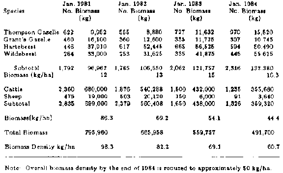
Table 10-1 Animal Populations and
Wildlife Ranching and Research, 1981-1984

TABLE 10-2 Wildlife Offtake at
Wildlife Ranching and Research, 1981-1984
TABLE 10-2 Wildlife Offtake at Wildlife Ranching and Research,
1981-1984
|
Year |
Number Harvested |
|
Gazelle |
Thompson Grant's Gazelle |
Hartebeest |
Total Wildebeest |
|
|
1981 |
243 |
154 |
97 |
36 |
530 |
|
1982 |
145 |
88 |
186 |
108 |
527 |
|
1983 |
187 |
76 |
179 |
120 |
562 |
|
1984 |
151 |
55 |
287 |
234 |
727 |
For the first 21 months, harvest was confined almost entirely to
surplus males. This altered the sex ratio of the herds to favor females 10:1.
This policy allowed growth in breeding stocks while providing saleable offtake.
Females were subsequently added to the harvesting program to maintain this
ratio.
During the first year, the natural increase of wildlife, adding
those harvested to the increase in numbers, totaled 40 percent. With the
increased female to male ratio, this total climbed to 50 percent for the
following years. This offtake rate was very high, considering that the average
offtake rate for cattle in the area averages only 17 percent.
Table 10-2 shows actual numbers and weights of animals harvested
over the four-year period. Gazelle were harvested rigorously and the other
species lightly at the start, but as the figures show, this was corrected over
the four years. The average weight of animals harvested declined significantly
over the period, reflecting the decline in the average age structure of the
herd. Of importance is the associated quality and tenderness of the meat, which
is very apparent to the consumer.
The fourth year, 1984, does not fit with the preceding years
because of a policy change in ranch operations and because of the worst drought
on record. The policy change was to increase the offtake of animals, mainly
because of the drought, but also because of the established policy of
maintaining and developing markets for wildlife products. The long-term goal is
to expand the base of operations, and continue to build a wildlife industry.
Indications were that the ranch was on the verge of receiving license to expand
its production base. It is interesting to note that demand for the product
continues to exceed supply.
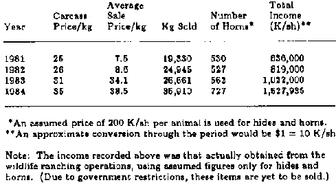
TABLE 10-3 Gross Returns from
Wildlife, 1981-1984
TABLE 10-3 Gross Returns from Wildlife, 1981-1984
|
Year |
Price/kg Carcass |
Average Sale Price/kg |
Kg Sold |
Number of Horns* |
Total Income (K/ah)** |
|
1981 |
25 |
7.5 |
19,330 |
530 |
636,000 |
|
1982 |
26 |
8.6 |
24,945 |
527 |
819,000 |
|
1983 |
31 |
34.1 |
26,661 |
562 |
1,022,000 |
|
1984 |
35 |
38.5 |
35,910 |
727 |
1,527,935 |
*An assumed price of 200 K/ah per animal is used for hides and
horns.
**An approximate conversion through the period would be $1 = 10 K/ah
Note: The income recorded above was that actually obtained from
the wildlife ranching operations, using assumed figures only for hides and
horns. (Due to government restrictions, these items are yet to be sold.)
In 1984, sales of 35,000 kg of dressed venison were recorded;
the meat sold as fresh carcasses, cuts and roasts, cooked and smoked sausages,
and biltong or jerky. An average price of over 39 K/sh (Kenya shillings) per kg
gave a gross return of 1.37 million K/sh for meat products. Table 10-3 shows
gross returns from wildlife over the four-year period.
How does the data relate and compare to traditional cattle
ranching? To answer this we will look at an economic survey commissioned by
Cornell University specifically to establish the viability of cattle ranching in
the area of WRR. The average ranch size of the 10 ranches sampled was 9,193
hectares. Averages of all the physical and economic measures and the technical
coefficients of these ranches were used to construct a budget representing the
average commercial cattle ranch in the district.
We will use this average scenario because it reflects actual
production and income figures for the area in the same way as our wildlife data
represents actual findings on WRR. Costs and prices used are for the year 1980,
yielding gross returns for the ranch of 919,200 K/sh. Cash expenditure was
830,054 K/sh, leaving a net profit of 89,146 K/sh. Assuming sales averaging 6
K/sh per kg live weight (the prevailing prices), and dressing out percentages of
50 percent, these figures translate into a production level of 8.33 kg per
hectare of carcass weight, yielding gross and net returns of 100.00 and 9.70
K/sh per hectare, respectively, for 1980. Assuming a 10 percent increase per
year in both income and cost, gross and net returns are shown for the succeeding
four years in figure 10-1.
FIGURE 10-1 Comparison of gross and
net returns.
Figure 10-1 compares this gross and net income with WRR income,
a mixed wildlife and cattle operation. The wildlife data is from production and
income levels for wildlife on WRR. The stocking rate of the average cattle ranch
in the sample was 1 livestock unit per 6.5 hectare. Assuming 400 kg per
livestock unit, this translates to 61.54 kg per hectare. Only in 1983 and 1984
do cattle on WRR fall below this stocking rate (see table 101).
It is assumed therefore that the mixed ranch carried the average
stocking rate for cattle in the survey of 61.54 kg per hectare for 1981 and 1982
along with the WRR wildlife stock, and that in 1983 and in 1984 the numbers of
cattle and wildlife are as actually existed on WRR, shown in table 10-1. This
shows gross returns for WRR nearly double that of the average cattle ranch, and
net returns almost 10 times greater.
A further economic advantage of the switch to wildlife was the
freeing of capital achieved from the sale of domestic animals. Over the
four-year period in question, WRR sold more than half its cattle stocks, or
nearly 50 kg per hectare, some 400,000 kg live weight. This has a cash value of
some 2.8 million K/sh, which, at 1983 exchange rates, exceeded a quarter of a
million dollars. Clearly, this money could go toward the conversions needed for
wildlife utilization, or be invested elsewhere to significant advantage. The
same advantage would be realized on many ranches in Kenya that already have
significant stocks of wildlife. In areas lacking wildlife populations, purchase
of stocks would necessarily negate this one-time windfall.
Meat production from the average cattle ranch in the same survey
is 8.33 kg per hectare of carcass weight. The mixed system on WRR (using the
same assumptions), averages 30 percent greater production over the four-year
period. Production from 1981 to 1984 would be 10.75, 11.45, 10.66, and 10.49 kg
of carcass per hectare, respectively.
Through the 1984 drought, WRR continued to supply game carcasses
in good condition to the market. Every week without fail, harvesting and sales
of the wildlife continued. Cattle ranches in the area suffered seriously, with
emaciated animals supplying little to the market.
There is no doubt that the experimental and demonstration ranch,
WRR, has benefited enormously from the inclusion of wildlife as the focus of
expanded operations. Gross income is double that of the average cattle ranch and
net income 10 times greater.
Income for the game, compared with cattle operations on WRR is
substantially higher, reflecting higher offtake rates, higher product prices,
higher dressing percentages, and the different sales method required for the
system. The very high offtake rates for wildlife reported here are among the
most important findings of the WRR operations, pointing to high fecundity and
reproductive growth of wild communities.
These findings dramatically contrast assertions in a 1983
Cornell University study. Surprisingly, this study drew definitive conclusions
on the complex question: game or cattle for meat production in Kenyan
rangelands? based on only eight months of involvement with the initial stages of
the WRR wildlife operations in 1981. This was before management or marketing was
stabilized, and before reproductive growth or offtake rates reported here were
established.
Prices for venison on the international market average nearly
twice those of beef, greatly enhancing the value of wildlife use. Considering
the low fat and the absence of chemicals, hormones, and antibiotics (the
presence of which tend to reduce the price of domestic meats in the Western
world), this price differential is anticipated to be long
lasting.
Conclusion
The system of land use for semiarid rangelands developed at WRR,
although in full operation for less than five years, demonstrates a method for
protection and regeneration of the land resource. The reestablishment of natural
species diversity enables the land to return to a positive condition, favoring
the entire range of native animals, plants, birds, insects, and soil organisms.
From a commercial perspective, the selective harvesting of game
animals has been a notable success. Net returns per acre are 10 times those of
the average cattle ranch in the area, yet the stocking of wildlife is still
one-sixth that of normal cattle numbers. A new industry has been developed in
Kenya as a result of this effort, and demand for wild game products from local
and foreign markets has developed rapidly.
In a variety of forms, the practice of game ranching has
steadily gained momentum worldwide over the past 20 years. Successful harvesting
operations are ongoing in New Zealand, South Africa, the Soviet Union, and
elsewhere. The focus of those activities, however, is generally on meat
production or sport hunting exclusively. The author's method, in contrast, is
multidimensional and more relevant to the specific needs of areas where both
economic development and resource protection are essential. His wildlife
land-use system rests midpoint on the line between conservation and production,
serving both while shortchanging neither.
We must now ask what should be done with the encouraging results
of this project. Can the model be applied in similar circumstances elsewhere?
Does it offer a solution to the desperate problems of deteriorating rangelands
in Africa and elsewhere, with the associated problems of food production and
income generation? Is the system flexible enough to be applied by or for people
with less specialized skills? How does it serve the interests of the indigenous
population - the pastoralists and
others?
Camel husbandry in Kenya: Increasing the productivity of ranchland
BY J.O. EVANS AND J.G.
POWYS
Introduction
As ranchers in Kenya, the authors of this paper have always
sought to obtain maximum production from their land. Several years ago, it
became apparent that camels might contribute to this aim. Initial results and
impressions are reported
herewith.
Location
Camels were introduced to four ranches between 1974 and 1978
(figure 11-1). They are:
· Galana Ranch (more than 400,000 hectares), which is south
of the equator in the hinterland of the Kenya coast. It lies on the fringe of
the coastal rainbelt in semiarid savanna at an altitude of 270 m above sea level
and receives an average rainfall of 550 mm. Tsetse fly (Glossina spp.) and
trypanosomiasis occur on parts of the ranch.
· 01 Maisor, Kisima, and
Ngare Ndare, which lie just north of the equator in Kenya's Laikipia district at
altitudes of between 1,730 and 1,890 m above sea level. All three ranches
comprise approximately 12,140 hectares and receive an annual average rainfall of
580 mm.
FIGURE 11-1 Map of Kenya showing
location of ranch" and sources from which camels were
obtained.
Vegetation
The vegetation on the Galana Ranch is influenced by declining
rainfall from east to west. In the extreme east, there is thick coastal bush and
forest containing Afzelia quanzensis, Brachystegia spiciformis, and Bombax
rhodognaphalon. This merges into light Diospyros mespiliformis parkland, which
in turn gives way to Acacia and Commiphora woodland. In the westernmost and
lowest rainfall zone, Commiphora spp. dominate. In all zones, there is extensive
open grassland composed of Chloris spp., Schoenefeldia transiens, and Aristida
spp., among a wide range of other species.
The other three ranches - 01 Maisor, Kisima, and Ngare Ndare -
have predominantly Themeda, Setaria, Hyparrhenia, Loudetia, and Cynodon
grasslands, scattered widely with Acacia seyal, A.gerrardii, and A.
drepanolobium. Bush and thicket containing Euclea, Rhus, Grewia, and Acacia
brevispica are also
widespread.
Livestock
All four ranches carry Boran cattle stocked at 4-6 hectares per
beast, Merino or crosses of Merino and Dorper sheep stocked at 1-3 per head of
cattle (with which they compete for grazing), and indigenous goats crossed with
exotic male introductions. The goats browse on low and medium-sized bushes,
controlling them and opening them up to permit the growth of grass that would
otherwise be shaded out. Their small size limits their effect on the larger
trees.
Introduction of camels
In 1974, 30 camels were purchased in the Wajir and Garba Tula
districts of northern Kenya and walked to the Galana Ranch. In 1975, an
additional 100 females were acquired in Moyale; 70 were moved to Galana and 30
to Ngare Ndare. Between 1975 and 1977, a number of camels were bought from the
Turkana and Pokot people of the Rift Valley and moved to 01 Maisor, where they
now number 102. In 1978, 20 females and a few males were bought in the northern
Wajir district and trekked to Kisima. Four commercial camel herds have thus been
established.
The purposes of acquiring camels were essentially experimental,
but several premises underlay the decision to experiment:
· By taking a spectrum of vegetation not used by the other
domesticants, camels would increase the productivity of all four
ranches.
· By eating many plants that grow among grass but are ignored
by cattle, sheep, and goats, the camels would improve the pasture for the other
animals.
· If camels provided milk for herdsmen normally dependent on a
supply from ranch beef cows, beef calves would not be deprived and would show
better growth.
· By providing transport, camels would be an economic
substitute for other forms in moving herdsman's chattels, rations, and
equipment, thus enabling the cattle herds to make best use of available grazing
(particularly on Galana).
· A base would be established for exploring
and, later, exploiting an increasing demand for camel meat in certain Kenya
towns, and the market for live camels in Arab states.
· A base would be
established for developing a wider trade in camels from Kenya's stock of more
than 600,000.
· The possibilities of making camel milk cheese and using
camel wool could be
investigated.
Management and adaptability
The camels are herded during the day and penned in thorn
enclosures (bomas or zaribas) at night. These enclosures are in close proximity
to others holding cattle, sheep, and goats. Their use is primarily as protection
against predators and thieves. They are moved to new locations every few weeks.
The camels withstood the transfer from low altitudes and very
arid climates to the high altitudes and slightly wetter conditions of 01 Maisor,
Kisima, and Ngare Ndare. Some were in poor condition on arrival, but thrived and
improved rapidly.
They are provided with a mixed mineral lick containing
phosphate, calcium, salt, and trace elements for which they show greater
appetite than cattle. These minerals are thought to be responsible for a better
bone structure apparent in the young animals grown on the ranches.
The Somali camels from Wajir, Moyale, and Garba Tula were tame
and tractable. Those from Turkana and Pokot in the Rift Valley were nervous,
head shy, and inclined to kick. Gentle handling and kindness changed this and
they are now docile and easily managed.
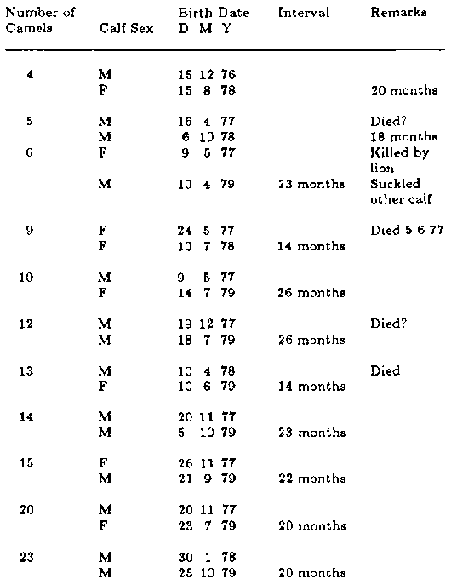
TABLE 11-1. Calving Records at Ngare
Ndare Ranch
TABLE 11-1. Calving Records at Ngare Ndare Ranch
|
Number of Camels |
|
Birth Date |
Interval |
Remarks |
|
Calf Sex |
D |
M |
Y |
|
|
|
4 |
M |
15 |
12 |
76 |
|
|
|
F |
15 |
8 |
78 |
|
20 months |
|
5 |
M |
16 |
4 |
77 |
|
Died? |
|
M |
6 |
10 |
78 |
|
18 months |
|
6 |
F |
9 |
5 |
77 |
|
Killed by lion |
|
M |
10 |
4 |
79 |
23 months |
Suckled other calf |
|
9 |
F |
24 |
5 |
77 |
|
Died 5 6 77 |
|
F |
10 |
7 |
78 |
14 months |
|
|
10 |
M |
9 |
5 |
77 |
|
|
|
F |
14 |
7 |
79 |
26 months |
|
|
12 |
M |
19 |
12 |
77 |
|
Died? |
|
M |
18 |
7 |
79 |
26 months |
|
|
13 |
M |
10 |
4 |
78 |
|
Died |
|
F |
10 |
6 |
79 |
14 months |
|
|
14 |
M |
20 |
11 |
77 |
|
|
|
M |
5 |
10 |
79 |
23 months |
|
|
15 |
F |
26 |
11 |
77 |
|
|
|
M |
21 |
9 |
79 |
22 months |
|
|
20 |
M |
20 |
11 |
77 |
|
|
|
F |
23 |
7 |
79 |
20 months |
|
|
23 |
M |
30 |
1 |
78 |
|
|
|
M |
25 |
10 |
79 |
20 months |
|
Several males and some females were trained for riding and
baggage transport. This was easy and was accomplished more quickly than would
have been the case with horses. They show strong individual character and are
very pleasant animals to work
with.
Reproduction and lactation
Maturity has been reached at between 6 and 8 years. Data from 11
females on the Ngare Ndare ranch are presented in table 11-1 and show an average
calving interval of 22 months (range 14-26 months).
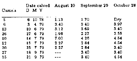
TABLE 11-2 Milk Yields (in liters),
Ngare Ndare Herd. Morning Milking
TABLE 11-2 Milk Yields (in liters), Ngare Ndare Herd. Morning
Milking Records Only; Very Dry Conditions.
|
Date calved |
August 10 |
September 29 |
October 28 |
|
Camels |
D |
M |
Y |
|
|
|
|
5 |
6 |
10 |
78 |
1.13 |
1.70 |
Dry |
|
6 |
3 |
4 |
79 |
3.40 |
3.40 |
3.97 |
|
13 |
10 |
6 |
79 |
3.12 |
3.69 |
3.40 |
|
26 |
27 |
6 |
79 |
1.98 |
2.27 |
2.55 |
|
10 |
14 |
7 |
79 |
7.00 |
4.26 |
4.54 |
|
12 |
15 |
7 |
79 |
2.27 |
2.84 |
4.54 |
|
20 |
23 |
7 |
79 |
2.27 |
2.84 |
3.40 |
|
27 |
18 |
9 |
79 |
--- |
3.40 |
3.40 |
|
15 |
21 |
9 |
79 |
--- |
3.40 |
4.54 |
Estrus has occurred at 4.5-10 months postpartum and, in one
instance in which there was a defective udder, 28 days.
Three gestations were recorded accurately; 2 male calves at 373
days, and 1 female calf at 393 days.
The young commence browsing at 1 month if the females have
little milk, but at 2 months if milk is abundant.
In tables 11-2 and 11-3 some data on milk yields are presented
from Ngare Ndare and Galana ranches. Although scanty, they illustrate a
potential that is within the range of that recorded by Knoess (1976) from the
Awash Valley,
Ethiopia.
Veterinary notes
Deaths have occurred from trypanosomiasis, pneumonia, and
hydatidosis in Turkana and Pokot camels; all of these diseases were contracted
before the camels were purchased. Since purchase, they have suffered from foot
abscesses, Corynebacterium abscesses, joint-ill (one calf on 01 Maisor), eye
infections, mange, and (on Galana) trypanosomiasis.
Off-color animals treated with tetracycline and compound
antibiotics have responded well.
Although worm egg counts are not necessarily indicative of a
serious problem with internal parasites, animals have been dosed with nilverm,
nilverm injectable, panacur, nemafax, thibenzole, and neguvon injectable, with
positive results.
The Galana animals are kept under prophylactic cover for
trypanosomiasis with apparent success by using antrycide sulphate and antrycide
prosalt (both drugs now no longer available).
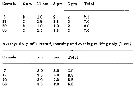
TABLE 11-3. Milk Yields (in liters)
Galana Herd. Comparison of Milk Records from 4 Females Milked 4 Times a Day and
Twice a Day.
TABLE 11-3. Milk Yields (in liters) Galana Herd. Comparison of
Milk Records from 4 Females Milked 4 Times a Day and Twice a Day.
|
Camels |
6 am |
11 am |
3 pm |
6 pm |
Total |
|
5 |
2 |
1.5 |
2 |
2 |
7.5 |
|
17 |
2 |
1.5 |
1.5 |
2 |
7.0 |
|
20 |
2 |
1.0 |
1.0 |
2 |
6.0 |
|
66 |
2 |
1.5 |
1.5 |
2 |
7.0 |
Average daily milk record, morning and evening milking only
(liters).
|
Camels |
am |
pm |
Total |
|
7 |
3.0 |
3.0 |
6.0 |
|
17 |
3.5 |
3.0 |
6.5 |
|
20 |
3.0 |
2.5 |
5.5 |
|
66 |
3.5 |
2.0 |
5.5 |
All animals have been vaccinated against blackquarter and
anthrax. The umbilical cords of newborn calves are tied with iodine-dipped
ligatures against joint-ill infection.
Mange has been serious in wet weather. Treatment with BHC and
alugan has been moderately successful, but delnav (organophosphorous) appears to
be most effective. A rubbing-post draped with sackcloth soaked in old engine oil
with delnav added provides a useful method of administration.
Brucellosis appears to be prevalent in the Galana herd.
Extensive tests were carried out recently by the Kenya Veterinary Department.
The tests were not conclusive, and it would appear to be very difficult to
isolate Brucella organisms in camels in the absence of freshly aborted fetuses.
Thirteen blood samples taken in April 1978 from 01 Maisor females were negative.
An attempt was made to infect two camels at Ngare Ndare with
corridor disease caused by Theileria lawrencei. The serum was negative for
antibodies and it was presumed camels are not susceptible to this disease.
Johne's disease was isolated in serological tests on Galana but did not appear
to cause a problem.
Foot abscesses and abscesses at the base of the neck and on the
rump cause considerable distress. Abscesses in the gland can become large and
require surgical removal. Pus from an abscess in one animal revealed
Corynebactcrium pseudotuberculosis and from another animal B-hemolytic
streptococci.
There was a virulent outbreak of foot-and-mouth disease, type
S.A.T. 2, in cattle, sheep, and goats on 01 Maisor, with which the camels were
in close contact; the camels were unaffected.
The breeding herd on Galana took two years to acclimatize and
commence breeding regularly. When first introduced to the area, they were not
given any prophylaxis treatment for trypanosomiasis for more than a year.
Abortions and premature births are common; a great many females were unable to
feed their calves.
Since they were injected regularly with antrycide sulphate, the
health and production of the herd improved
dramatically.
Economics
While the price of camera is comparable to that of good quality
cattle, the distance from the ranches at which they have had to be purchased has
made their acquisition very costly.
Direct expenses incurred in their upkeep have proved less than
those for our cattle (KSh 70/- to 80/per year without overhead). This is mainly
because they have not needed the regular and obligatory dipping or spraying
required by cattle to protect them from the ticks and tick-borne diseases to
which cattle are prone.
The slow reproductive rate of 22 months compared to less than 14
months for ranch cattle, and slow maturing rate of 6-8 years against 3-4 years
for finished steers, indicates a poor economic potential.
The return from camels might be improved with experience and
improved husbandry. It should be possible to reduce the calving interval to 18
months (Knoess, 1976). Milk production might also be taken into account.
Even with such improvements, cattle will remain the more
profitable animals. However, we must emphasize that our camel productivity is
additional to and in no way competitive with our beef production or any other
livestock on the property.
We have every hope that the quality of our camel stock will
improve; our foundation animals tended to be culls that the sellers thought to
be defective. It might speed up growth and individual quality if young animals
could be weaned and hand fed (the Turkana say that they rear camel calves
successfully on cow's milk).
When purchasing stock, it is advisable to try and buy unbred
females and to avoid buying heavily branded animals, as this is generally an
indication of some defect or illness. The pastoral people of Kenya use the
practice of firing (the application of hot metal) for almost any ailment.
NOTE
Thanks are due to the Kenya Department of Veterinary Services
and those members of the veterinary profession who have helped and advised us.
The camel lore and good advice received from members of the Somali and Turkana
tribes are greatly appreciated by the
authors.
Reference
Knoess, K. H. 1976. The camel as a meat and milk animal. World
Animal Review No. 22, pp.
3-8.
The potential of faidherbia albida for desertification control and increased productivity in Chad
BY ROBERT D. KIRMSE AND BRIEN E. NORTON
Reforestation using Faidherbia albida (also known as Acacia
albida) has been proposed as a mechanism for combating desertification trends in
the Sahel. This tree is characterized by a deciduous habit in the wet season; it
is valuable for fodder, as a hardwood in woodwork industries, and for enhancing
soil fertility of cropland. In a three-year project described in this case
study, the establishment of Faidherbia albida plantations in cultivated fields
in central Chad is conceived as a focal point to coordinate resource
conservation and land development programs. Several hundred thousand young trees
were established and about 2,500 farmers and their families participated in the
revegetation program. The success of the project must be evaluated, however, in
terms of the prospects for longterm benefit and recognizing the sociological
problems of assistance
programs.
Background
Chad is one of the poorest countries in the world, with a per
capita income of less than US$100. It is a landlocked Sahelian country with all
of the complex problems associated with a fragile arid ecosystem and an economy
based on small-scale subsistence farming and livestock grazing. It has a short
growing season, poor soils, uneven rainfall patterns, and is subject to cyclical
droughts. During the drought period between 1970 and 1973, agricultural
production was reduced by approximately 62 percent (Government of the Republic
of Chad, 1977). Per capita food production, even before the drought, declined 32
percent from 1961 to 1970.
These trends may be indicative of two developments: an expanding
population on a limited land resource, and a degradation of the land's
productivity. It is probably a combination of these two factors that results in
a poor country's getting poorer and less able to feed itself, much less protect
its ecosystems from instability and degeneration.
In the Sahel, modernization is encouraging migration to the
cities and the settlement of the nomads. This trend, along with improved medical
services, is prompting an increase in localized population pressures with
consequent growing demands on the adjacent land resources. To meet these
expanding demands, development priorities are directed toward projects that will
quickly solve immediate problems. The introduction of Western technology
increases expectations of the land's resources while providing no guarantee of
sustained high productivity. This only tends to compound the problems of
environmental degradation in Chad. Some examples of development projects in Chad
that could fit this counterproductive category are animal traction tilling,
borehole development, introduction of cash crops, and irrigation projects.
The traditional method of seedbed preparation in Chad is the
simple scratching of the soil surface with a hand implement and dropping seed
into the depressions. Farmers who see the higher first-year crop yields
resulting from animal-traction tilling are easily convinced of its merit. There
is, in fact, a firstyear increase in crop yield after plowing (Charrire, 1978),
but repeated plow cultivation and loss of perennial root systems leads to a
depletion in soil structure and fertility as the fields are made vulnerable to
wind erosion and the organic matter is more rapidly oxidized.
Water developments for the benefit of livestock production have
had severe effects on the ecosystem in Chad. Additional water allows a growth of
herd size and encourages locally intense range retrogression around boreholes
(Le Hou�rou, 1980).
The introduction of cotton as a cash crop into Chad has
compounded the problems of resource stress. Much of the suitable cropland is
devoted to this "luxury crop," with encouragement from local government. Cotton
is now the first crop to be planted on a five-year rotation with millet,
sorghum, and peanuts. It requires more fertile soil and it removes more
nutrients than the other crops.
The technology of irrigation, with complex pumps that require
imported parts and regular servicing, appears out of place in Chad. Without an
extensive, easily obtained water supply, irrigation projects tend to build
expectations that may be illusory. There are relics of ephemeral irrigation
projects that folded soon after the expatriate technician left. The level of
technology applied is rarely understood within the cultural context of the
Sahelian villager and thus often not maintained by him. This may eventually be
regarded, however, as the redeeming virtue of misapplied Western technology in
the Sahel: a lack of permanency.
Compounding the problems associated with the application of
inappropriate Western technology, agricultural development projects in Chad
rarely cooperate with one another for the optimization of resource utilization.
Some believe it is a result of interagency jealousy among the host country
government offices, or distrust, or lack of communication, or tribalism, or just
a basic lack of interest to cooperate at the local ministerial level. These
considerations could, and do, impede project coordination, but the technical
assistance community is equally at fault for many of the same reasons.
Viewing the problem of desertification in its entirety reveals
the prerequisite of balancing resource availability with coordinated resource
utilization. This proper use of resources will only be possible when there is
cooperation among the various users. The forester, the agronomist, the soil
scientist, and the range manager must work together with the farmer and herder
to obtain maximum long-term productivity from the land. The question therefore
becomes how to organize the foreign technical assistance programs into an
ecologically sound unit easily understood and likely to be received by the rural
villager.
An innovative rural development project in Chad during the
period 1976 to 1979 proposed the application of a popular and easily understood
concept of revegetation using the versatile Faidherbia albida tree as a means to
focus concern and unify efforts of the various agricultural development groups.
Planting Faidherbia albida on marginal farmlands of the Sahel is
not an end in itself. The project was designed also to coordinate development
efforts and bridge the communication gap between the technical assistance agent
and the villager. As the extension worker learns to understand the cultural
constraints of the villager, and as the villager gains confidence in the
extension agent, a more complete land management program may evolve that could
include all aspects of agricultural and livestock production development.
The final goal is a culturally acceptable, ecologically oriented
program for integrated land management. This integrated development approach to
ecological stability in the Sahel may be termed an agro-sylvopastoral approach,
signifying a unification of efforts. (Agro-sylvo-pastoral is becoming a popular
term used in francophone Africa to imply the cooperative development efforts of
the agricultural [agro],sylvicultural [sylvo-], and range management [pastoral]
disciplines.)
Characteristics of faidherbia albida
Faidherbia albida, or Acacia albida, is referred to in Arabic as
the haraz. It is a member of the legume family and of the subfamily Mimosoideae.
The species is characterized by bipinnate leaves, orange curled seed pods,
cream-colored flowers, and thorns.
Faidherbia albida reaches heights of 3-10 m in 10 years,
depending on environmental conditions (Wickens, 1969). It may grow as a shrub if
continually grazed (Wickens, 1969), but usually develops into a tree with a
large spreading crown. The mean maximum height is 25 m, with a girth of 5 m
(United Nations Development Programme and Food and Agriculture Organization of
the United Nations, 1968). It is a long-lived species, with an average life span
of 70-90 years in the Sudan and known to live more than 150 years in Zambia
(Wickens, 1969).
Faidherbia albida has an extensive taproot system that develops
rapidly to reach an adequate moisture layer. This characteristic makes the
species relatively drought-resistant. On the coarse alluvial sands of the Sudan,
a 6-month-old seedling with 8 cm of areal growth had a taproot of 70 cm
(Wickens, 1969). A 3-year-old seedling excavated in northern Nigeria produced a
taproot in excess of 9.9 m (Weber, 1978).
The most unusual phenological characteristics of the species are
retention of the leaves during the dry season and shedding of leaves at the
onset of the wet season. No other African savanna species is known to possess
this reverse deciduous cycle (Wickens, 1969; Weber, 1978).
In Africa, Faidherbia albida is found wherever there is a long
dry season: from southern Algeria to Transvaal and from the Atlantic to the
Indian Ocean (Giffard, 1964). It prefers a well-drained sandy soil with a
permanent water table, but will also grow on clay soils (Wickens, 1969); Weber
(1978) indicates that it may be found anywhere millet can grow. It typically
occurs on bush-fallow of cultivated fields or land grazed by livestock, and
rarely occurs in natural woodlands that have not been exploited by man. Wickens
(1969) suggests that this might indicate that Faidherbia albida is an alien
species of uncertain origin.
Natural regeneration of the species is both stimulated and
repressed by grazing animals. The seedpods are highly palatable and livestock
can distribute the seed 150 km from the source. Ruminant digestive juices
stimulate seed germination (Weber, 1978). With increased grazing pressure and
more intensive cultivation, however, natural regeneration is becoming more
difficult for all perennials of the Sahel, including Faidherbia albida.
Because of its beneficial qualities as an important dry season
fodder, source of fiber, a shade tree during the hot period of the year, and a
preferred location for crop production (McGahuey and Kirmse, 1977), it is a
protected species in many parts of the Sahel (Dancette, 1968).
Blancou et al. (1977) have shown that browse is a very important
component of the dry-season diet for cattle in the subtropics, providing the
principal source of protein and carotene. Reports of the crude protein content
of Faidherbia albida leaves range from 14 percent to 17 percent, and three
studies of the chemical composition of pods averaged 12.2 percent crude protein
(Wickens, 1969). The highly nutritious and palatable pods and leaves of
Faidherbia albida are readily consumed by all domestic and wild herbivores.
Nomadic herdsmen typically lop the branches to provide browse for their stock;
the seedpods fall to the ground in March and April during a time of nutrient
stress for Sahelian herbivores.
Dense stands of the tree can provide forage equivalent, from
pods alone, greater than any other local forage on a per hectare basis
(Charreau, 1974; table 12-1). A wood savanna in which Faidherbia albida is the
dominant tree species is able to stock 20 animal units per km² as compared
with 10 animal units when Faidherbia albida is not present (Giffard, 1964).
Extensive research on the soil-enriching properties of
Faidherbia albida has been undertaken in Senegal (Charreau and Vidal, 1965;
Jung, 1967, 1970; Dancette and Poulain, 1968), and in Niger by Dougain (1960).
All soil nutrient properties were observed to be improved by the presence of the
species. Increases from 20 percent to 100 percent were found in the nitrogen,
available phosphorus, and exchangeable calcium content of the soil (Jung, 1967).
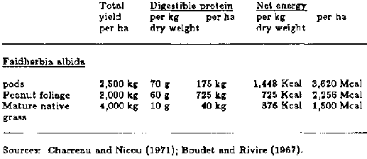
Table 12-1 Fodder Value of Pods of
Faidherbia albida Compared with Peanut Tops and Mature Native Grass
Table 12-1 Fodder Value of Pods of Faidherbia albida Compared
with Peanut Tops and Mature Native Grass
|
Total yield per ha |
Digestible protein weight per kg dry |
Net energy per ha |
per kg dry weight |
per ha |
|
Faidherbia albida pods |
2,500 kg |
70 g |
175 kg |
1,448 Kcal |
3,620 Mcal |
|
Peanut foliage |
3,000 kg |
60 g |
725 kg |
725 Kcal |
2,256 Mcal |
|
Mature native grass |
4,000 kg |
10 g |
40 kg |
376 Kcal |
1,500 Mcal |
Sources: Charreau and Nicou (1971); Boudet and Rivire (1967).
Studies by Dougain (1960) in Niger indicate that on a 10-cm
depth basis, which represents about 1,500 tons of soil per hectare, the nutrient
increases due to the presence of Faidherbia albida were equivalent to the
following amounts of fertilizer amendments per year: 300 kg nitrogen, 31 kg
phosphorus as P2O5 and 24 kg magnesium. The tree also served as a windbreak,
which protects crops and native vegetation from mechanical damage and excessive
transpiration (Dancette, 1968).
Charreau and Vidal (1965) calculated that under Faidherbia
albida trees in Senegal, millet production was 2.5 times that of crops grown in
the open, and protein content of the grain was up to 4 times greater. Dancette
and Poulain (1968) demonstrated that peanut production can be 36.7 percent
greater under the influence of Faidherbia albida.
The nutritional benefit of Faidherbia albida to crops grown
beneath the canopy is consistent with the "islands of fertility" concept
described by Garcia-Moya and McKell (1970) for shrubs and trees in semiarid
lands. Woody perennials extract nutrients from deeper layers of the soil profile
and deposit them at the surface in litter (Charley, 1972; Fireman and Haywood,
1952; Rickard, 1965). These plants also provide cover for animals and trap
wind-borne debris. Soil water retention may be as much as 43 percent higher
under the canopy of Faidherbia albida (Charreau and Vidal, 1965). A more
favorable moisture and temperature environment will promote microbial
decomposition and nutrient release. Since Faidherbia is a legume, symbiotic
nitrogen fixation may contribute to the nutrient pool enhancement.
The characteristic reverse deciduous cycle of Faidherbia albida
is a key physiological property that allows satisfactory production of crops
under a full stand of the species. The leaves are shed at the onset of the rainy
season, allowing sunlight acces to the crops and reducing competition for water
in marginal croplands.
The wood of the Faidherbia albida tree is hard, and favored
locally for the construction of mortars and pestles as well as for other light
carpentry uses. Localized uses also include charcoal production and dugout canoe
construction. The bark can contain up to 28 percent tannin and is used for
treating hides (United Nations Development Programme and Food and Agriculture
Organization, 1968).
The above-mentioned multiple use qualities of Faidherbia albida
indicate that the species would be of interest to (1) the agronomist for
increasing crop production without the use of expensive fertilizers; (2) the
livestock producer for fodder during the dry season, as well as for shade; (3)
the watershed manager for improvement in soil waterholding capacity and decrease
in erosion; (4) the forester for timber uses; and (5) the farmer as an
improvement in his living standards without a change in cultural traditions. It
is for these considerations that Faidherbia albida can be a focal point of a
coordinated agrosylvo-pastoral land management program.
Many authorities on the problem of desertification recommend
planting the species as an appropriate land management component in the Sahel
(Catinot, 1974; Dancette, 1968; Delwaulle, 1973; Giffard, 1971; Guilloteau,
1953; Weber, 1977). There have been several attempts to organize land management
programs using Faidherbia albida - in Niger, Senegal, Nigeria, and Chad. The
Chad project is an interesting case study of the possibilities and problems of
such a
program.
Project description
In June 1976, the Cooperative for American Relief Everywhere
(CARE), with funding from the United States Agency for International Development
(USAID), set out to try an ecological approach to increase productivity and
improve resource management in Chad by the planting and protection of Faidherbia
albida trees on marginal farmlands. It was hoped that this popular and visible
planting program would serve as a tool that could bridge the gap of
communications among the various development agencies and the villages so that
an integrated resource management program of a larger and broader nature might
develop.
The 3-year project proposed the planting of 100 seedlings of
Faidherbia albida per hectare on 3,500 hectares of marginal farmland that was
currently under cultivation. One hundred seedlings per hectare is 5 times the
number of mature trees recommended by Giffard (1964) as sufficient to-provide
continuous cropping without the need of intermittent fallow periods. Because of
the expected mortality of seedlings, this high planting intensity was considered
necessary to ensure the survival of the desired numbers of trees and their
proper distribution.
Cultivated fields, rather than abandoned fallow fields, were
targeted for planting for two reasons: (1) to work with and employ the local
farmers, following Eckholm's (1976) reasoning that the local inhabitants must
willingly participate and recognize their self-benefit before a conservation
project will succeed; (2) survival rates are much higher in cultivated fields
than fallow land because of the extra protection the farmer provides against
fire, grazing pressure, and grass competition (CARE, 1978).
The project area consisted of marginal farmlands just north and
south of the 400-mm rainfall belt, which includes the arid fringes of the desert
between latitudes 10°N and 13°N, with annual rainfall ranging from
less than 200 mm in the north to 700 mm in the south. This area was selected to
demonstrate project technology in the most critically affected zone of the
desertification phenomenon.
The land was inhabited by various tribes of sedentary farmers
and pastoralists including the Sare, Moundan, Fulani, Arabs, Toubouri, Massa,
Baguirmi, and Kotoko. Of these only the Sare, Moundan, Toubouri, and Massa had
an inherent understanding of the benefits of Faidherbia albida and a tradition
of protection and respect for the tree; other tribes have recently settled the
area, coming from regions where the tree does not occur. Cultivated crops
include millet, sorghum, cotton, and peanuts; livestock in the area include
cattle, sheep, goats, and camels.
The program design specified an initial questionnaire to obtain
some semblance of understanding of local needs, perceptions, and resource
constraints. The survey sampled all locations of the project in order to canvass
the various tribes and detect cultural differences.
Time and language constraints rendered this endeavor practically
worthless. The project managers, who were from the United States, spoke in
French (through a translation to Arabic) to the villagers whose mother tongue
was any of a number of local dialects. The translators (French to Arabic) were
Chadian Forest Service agents of the ruling class tribe (Sare), which was not
trusted by the other groups.
Time was a limiting factor because the project was required to
produce tangible evidence of progress before the first rainy season or else lose
funding credibility. Therefore, out of necessity, and, it was hoped, in fairness
to all tribal members, the program was standardized: one policy for project
operation was applied to all participants (at the expense of adjusting to the
various cultural differences).
Project Implementation
Nine nursery and extension centers were established in various
locations ranging from 150 km north to 250 km south of N'Djamena. Local
villagers were hired and trained to run the nursery operations Every effort was
made to establish nursery techniques for seedling propagation commensurate with
locally obtained materials and indigenous technology.
Approximately 2,500 farmers and their families participated in
the revegetation effort. The targeted 3,500 hectares were all planted by the
third growing season. An organized campaign was necessary to ensure that all
seedlings were in the ground within a two week period at the onset of the rainy
season. This planting-out component of the program proved to be clearcut in
terms of social and environmental complications, especially in comparison with
the truly difficult task of protecting the seedlings in the field after their
establishment.
In the first year of operation, 54,000 seedlings were planted on
540 hectares of cropland. Within the next 12 months, there was a mortality rate
of 73 percent, resulting in survival of only 14,500 saplings. In the second
planting season, 285.500 seedlings were established with 58 percent survival,
mainly because of an improved protection program, bringing the total number of
saplings after 2 years to 178,000. Oneyear-old plants had a much higher capacity
for survival. During the third season (1978), 292,000 seedlings were planted.
Combined mortality for seedlings and older plants was to be about 26 percent,
leaving 350,000 young plants by the fourth year from the 470,000 cumulative
total population.
Among the mortality factors, grazing pressures caused the
highest losses. Faidherbia albida is highly palatable to all herbivores, and,
being one of the few species with green foliage during the dry season, it was
readily taken if not protected. Perimeter fencing of the land was not possible
or desired, as this would have disrupted the traditional grazing patterns of the
nomadic herder. Furthermore, imported fencing materials that would resist the
rigors of the environmental conditions were highly prized by the local villagers
and rapidly disappeared. Instead, the laborious task of fencing each individual
tree with suitable local materials, such as thorny branches, was undertaken.
Uncontrolled range fires also took a heavy toll of the young
seedlings. Convincing the villagers and nomadic herders to refrain from their
traditional burning habits was futile. Here again, the only solution proved to
be a major task, that of clearing fire lines, 2 m in radius, around every
seedling. This clearing of the native grasses also served to remove competition
for soil moisture in favor of the Faidherbia seedling.
Where termite infestation occurred, insecticides were applied on
a tree-by-tree basis. Fencing material also had to be protected from the
ravaging termites by a combination crankcase oil and insecticide treatment.
Crankcase oil was more easily obtained and less expensive than commercial wood
preservatives.
There were, of course, unfavorable environmental factors
completely outside the control of project management. Periodic droughts could
not be controlled. The rainy season normally lasts about 2-3 months in this part
of Africa, leaving a pronounced dry period the rest of the year. For a seedling
to take root before this long dry season, it had to be planted early during the
rainy season, but only after the soil was moist to a depth of 40 cm (CARE,
1977). Correct planting time was critical to seedling survival, but
unfortunately was highly dependent on luck. If a two-week dry period occurred
immediately after the seedling was planted, chances of survival greatly
decreased. Another seedling mortality factor beyond control of the project
management was damage inflicted by elephants that selected Faidherbia albida
saplings as preferred browse (CARE, 1977).
Technology Transfer Problems
In the face of environmental dispositions toward mortality, the
predominant influence on seedling survival derived from the interest of the
farmer who planted and protected the seedlings on his land, especially his
understanding of the purposes of establishing the tree and the benefits it would
bring.
In an effort to achieve an adequate level of understanding, an
intensive training and sensitization program was initiated. Films were made,
talks given, and demonstrations presented. All of the conventional western
extension tactics were employed to promote the idea of Faidherbia albida as a
key to proper land management. Interest was certainly generated, although not
for the reasons one would have wanted. As one CARE employee pointed out, "We are
the only show in town."
It was necessary to prop up the extension efforts with an
incentive policy to attract the initial participation of local villagers into
the revegetation scheme, and to encourage continuous protection of the planted
fields. This incentive component involved the distribution of American-donated
food commodities (called "food for work" ). Some contend that giving food
creates a dependency and an expectation by villagers that they must be
compensated for their efforts to help themselves. This is a reasonable fear, but
project experience demonstrated that satisfactory participation is simply not
possible without such food, or some other incentive. (Actually, the Chadian
chief of the Forest Service suggested cash payments would be necessary.)
In most cases the village chief (Blahma) or religious head
(Sultan) was the instrument of local project administration, which turned out to
be a most successful extension arrangement. The ethnic diversity of the area
presented insurmountable obstacles for complete coordination of activities.
People of different tribes in this part of the Sahel (and probably elsewhere)
simply do not work together.
The project was heavily burdened by the traditional problems of
incomparability between government extension agents and rural villagers.
Government agents tended to assume a patronizing attitude in their extension
methods. They were well trained technically, but poorly prepared to communicate
ideas to the rural villagers or to motivate farmers to support the idea of the
agro-sylvo-pastoral
program.
Project analysis and evaluation
Most foreign assistance projects concerned with agricultural or
pastoral development in Third World countries operate on assumptions, both
technical and sociological. The technological transfer process generally assumes
that the technology used in the developed country will work equally well in the
client country. Because of critical deficiencies in research and lack of
expertise of Western technicians in the Sahelian situation, this assumption is
often found to be faulty. A classic example of misapplication of technology is
the use of sophisticated machinery in a land remote from spare parts, and among
people unaccustomed to engine maintenance. The advantage of the
agro-sylvo-pastoral program in Chad is that the "technology" of Faidherbia
albida is natural to the Sahel, time-tested, and well studied by research
scientists.
Assumptions concerning the social implications of rural
development programming in the Sahel are yet more complicated, as they deal with
intangible and elusive cultural nuances. It hardly can be expected that a
technical expert will fully understand the cultural setting within which he is
to operate. In fact, pretensions to understand often lead to the chronic
problems of Western ideas being imposed on unwilling villagers. This is not to
imply that project personnel should ignore the cultural context; rather, they
should be sensitive to the needs of the villagers and include local input into
the planning as well as the implementation phases.
The problems of change agents who are unfamiliar with client
needs and perceptions, insensitive to different socioeconomic status and the
particulars and complexions of different ethnic groups, who presume to know what
is best for the client, and assume only temporary involvement in improvement
projects, are examined in depth by Mbithi (1974) in a Kenyan context. These are
universal issues in rural development, and the Faidherbia albida project was no
exception. In the latter case, an idea - an ecological concept with commercial
agricultural value was to be imposed on the villagers with the assumption that
the local inhabitants understood or could be taught the principles of the
program. This proved to be the weakest point of the project. Farmer
understanding was critical to the success of the program but yet was based on
nothing more than Western hope and expectations. For all practical purposes,
there was no effective local planning, and the project had to rely on free food
incentives for motivation instead of on the villagers' adoption of program
objectives.
From another point of view, transmitting a thorough
understanding of the ecology of a Faidherbia albida plantation may have
jeopardized the project. Under the traditional cropping system, soil fertility
is depleted after about five harvests and the farmer and his family then move on
and clear a virgin or recovered field. But it takes Faidherbia albida about 15
years to reach maturity and produce the promised benefits. The cooperative
farmers who carefully watched over the seedlings established on their cropland
for the CARE program would have to abandon their husbandry 10 years before the
fruits of their labor could be fully realized. The trees protected for those
four or five years would be able to make it on their own, and the objectives of
the project would be reached eventually, possibly at the expense of the original
partnership between donor and farmer if the latter did not return to the same
field.
The project was a technical success because it reached its goal
of planting 3,400 hectares, and involved over 2,000 farmers, plus their
families, in the three-year effort. It was also successful in providing a focus
to coordinate the interests of various technical assistance groups working in
the country.
On a sociological scale, the project could be rated a failure
because of the requirement of a food incentive to assure participation. The
15-year delay before plantation benefits are realized cannot be overlooked while
evaluating the impact of this project on a people living at a subsistence level.
It has been observed that African languages often do not allow for a future
tense (Mbit), 1969); this could definitely handicap a project with long-term
goals.
It would seem, therefore, that the change agent (in this case
CARE) should be required to remain active in the project until benefits can be
seen by the recipients, but this condition is generally constrained by the modus
operandi of the funding agency. In 1976, USAID, for example, would only fund
projects for periods of three years at a time. At the end of each three-year
period, continued funding was dependent on proven success, such as increased
animal production, increased agricultural output, or increased rural jobs. This
project, by nature of the biology of the development tool, required much longer
than three years to realize production gains or social changes. For this reason,
a program with an ecological orientation such as this is less likely to receive
continued financial support compared with irrigation, veterinary services,
fertilization, and farm mechanization improvements. or other highly visible
projects with short-term objectives.
It is imperative that a project with the far-reaching goals of
the Faidherbia albida establishment program continue to be motivated by the
extension agent until the clients see the results of their efforts and become
willing participants.
Unfortunately, this project did not continue. The reasons,
however, had nothing to do with the inherent problems of rural development
programs. The sudden and unexpected end of the project was caused by the coup
d'�tat in Chad in 1979, an event that underlines the ultimate prerequisite for a
successful desertification control project - a stable governmental structure
within which to
work.
Conclusions
The desertification process is a complex web of environmental
disturbances, and its control is confounded by a labyrinth of social and
ecological complications. "Modernization" has reached a stage in the Sahel such
that a return to traditional ways would not be possible, even if desirable, as a
means to check the "desert creep." It is in the interest of the developed world
to work with the affected countries to find an ecologically sound and socially
acceptable solution to the degradation problem. The ecological understanding
necessary to apply conservative land management is available, but because of
social and cultural differences the framework within which it may be properly
applied has not yet been developed.
A suitable framework for development and conservation of the
Sahelian ecosystem must involve a unified effort on the part of all sectors of
agricultural and livestock production to ensure proper use of the land's
resources. Development efforts in the Sahel, however, do not have a history of
such cooperation; coordination of efforts will come only with coordination of
interests. The unique multipleuse characteristics of Faidherbia albida, built
into a rural development project, could be a device to focus related interests
and forge cooperation between development efforts that have obvious ecological
connections. This facilitation may ultimately be more helpful to the recipient
country than the direct benefit of Faidherbia albida plantations to the
agricultural and forage resources of the
land.
References
Blancou, J., H. Calvert, D. Friot, and J. Valenza. 1977.
Composition du p�turage naturel consomme par les bovine en milieu tropical; note
sur une technique d'�tude nouvelle. Bouak�, C�te d'Ivoire. (Mimeographed.)
Boudet, G., and R. Rivi�re. 1967. Emploi pratique des analyses
fourrageres pour l'appreciation des p�turages tropicaux. Institut d'�levage et
de M�decine V�t�rinaire des Pays Tropicaux. S�n�gal. (Mimeographed.)
CARE. 1976-1978. Quarterly reports on the Acacia albida
extension project. CARE, N'Djamena, Chad. (Mimeographed.)
Catinot, R. 1974. Contribution du forestier � la lutte contre la
d�sertification en zones s�ches. Bois Forestier Tropical 155:3-13.
Charley, J. L. 1972. The role of shrubs in nutrient cycling. Pp.
182-203 in: Wildland Shrubs - Their Biology and Utilization, An International
Symposium, Utah State University, Logan, Utah, July 1971, edited by C. M.
McKell, J. P. Blaisdell, and J. R. Goodin. General Technical Report INT-1. U.S.
Department of Agriculture Forest Service, Intermountain Forest and Range
Experiment Station, Ogden, Utah, USA.
Charreau, C. 1974. Soils of tropical and dry-wet climatic areas
of West Africa and their use and management. Cornell University, Ithaca, New
York, USA. (Mimeographed.)
Charreau, C., and R. Nicou. 1971. L'am�lioration du profit
cultural dans les sols sableux et sabloargileux de la zone tropicale s�che
Ouest-Africaine et ses incidences agronomiques. Agronomie Tropical 26:565631.
Charreau, C., and P. Vidal. 1965. Influence de I'Acacia albida
Del. sur le sol la nutrition min�rals et les rendements des mils Pennisetum au
S�n�gal. Agronomie Tropical 20:600-625.
Charri�re, G. 1978. Le desert des paysans: la destruction des
sols au Tchad par le d�veloppement de l'agriculture. Swiss Aid, Bern,
Switzerland.
Dancette, C. 1968. Note sur les avantages d'une utilization
rationnelle de l'Acacia albida (Faidherbia, Kad, Sas) au S�n�gal. Centre
National de Recherches Agronomiques, Bambey, S�n�gal. (Mimemographed.)
Dancette, C., and J. Poulain. 1968. Influence de l'Acacia albida
sur les facteurs pedoclimatiques et les rendements des cultures. Centre National
de Recherches Agronomiques, Bambey, S�n�gal. (Mimeographed.)
Delwaulle, J.-C. 1973. D�s�rtification de L'Afrique au sud de
Sahara. Bois Forestier Tropical 149:3-20.
Dougain, E. 1960. Report de mission au Niger. Institut Frangais
de Recherche Scientifique pour le D�veloppement en Coop�ration, Dakar, S�n�gal.
(Mimeographed.)
Dregne, H. 1977. Desertification of arid lands. Economic
Geography 53:322.331.
Eckholm, E. P. 1976. Losing Ground - Environmental Stress and
World Food Prospects. W. W. Norton, New York, New York, USA.
Fireman, M., and H. E. Haywood. 1952. Indicator significance of
some shrubs in the Escalante Desert, Utah. Botanic Gazette 114:143-55.
Garcia-Moya, E., and C. M. McKell. 1970. Contribution of shrubs
to the nitrogen economy of a desert wash plant community. Ecology 51:81-88.
Giffard, P.-L. 1964. Les possibilit�s de reboisement en Acacia
albida au Senegal. Bois Forestier Tropical 95:21-32.
Giffard, P.-L. 1971. Recherches complementaires sur Acacia
albida. Bois Forestier Tropical 135:3-20.
Government of the Republic of Chad. 1977. Annuaire statistique
du Tchad. N'Djamena, Chad, S�n�gal. (Mimeographed.)
Guilloteau, J. 1953. Scheme for the improvement of the
agricultural economy of S�n�gal. African Soils III(2).
Jung, G. 1967. Influence de l'Acacia albida Del. sur la biologic
des sols div. Centre National de Recherches Agronomiques, Bambey, S�n�gal.
(Mimeographed.)
Jung, G. 1970. Variations saisonni�res des caract�ristiques
microbiologiques d'un sol ferrugin� tropical peu lessive (dior), soumis ou non a
['influence d'Acacia albida. Ecol. Plan. Gouteier-Villars 5:113-136.
Le Hou�rou, H. N. 1980. The rangelands of the Sahel. Journal of
Range Management 33:41-45.
Mbithi, P. 1974. Rural Sociology and Rural Development: its
Application to Kenya. East Africa Literature Bureau, Nairobi, Kenya.
Mbiti, J. S. 1969. African Religions and Philosophy. Heinemann,
London, England.
McGahuey, M., and R. Kirmse. 1977. Acacia albida Expansion
Project Field Operations and Training Manual. CARE, N'Djamena, Chad.
Rickard, W. H. 1965. Sodium and potassium accumulation by
greasewood and hopsage leaves. Botanic Gazette 126:116-119.
United Nations Development Programme and Food and Agriculture
Organization of the United Nations. 1968. Important Trees of the Northern Sudan.
University of Khartoum Press, Khartoum, Sudan.
Weber, F. 1977. Reforestation in Arid Lands. Action/Peace Corps,
Program and Training Journal, Manual Series, No. 5. Peace Corps, Washington,
D.C., USA.
Weber, F. 1978. Midpoint Evaluation: Chad Reforestation Project.
Consultants in Development, Washington, D.C., USA. (Mimeographed.)
Wickens, G. 1969. A study of Acacia albida Del. (Mimosoideae).
Kew Bulletin
23:181-200.
Improving Nigeria's animal feed resources: Pastoralists and scientists cooperate in fodder bank research
BY SIMON CHATER
Research on fodder banks in Nigeria's Middle Belt has reached a
crucial stage as scientists on the Subhumid Zone Programme of the International
Livestock Centre for Africa (ICLA) confront pastoralists adoption problems.*
The pastoralists have mixed feelings about their fodder banks.
They say the 4-hectare fields of Stylosanthes are an expensive investment and
too small to meet the supplementary feed requirements of all their animals. Yet
those who have them are retaining and occasionally expanding them, and the
number of fodder banks in the region continues to rise.
More than 70 fodder banks have now been established in Nigeria.
During the early stages of the research, establishment costs were borne by ILCA,
but now the pastoralists themselves are shouldering the burden. To help them,
Nigeria's National Livestock Project Unit is extending credit for fencing,
seeds, and fertilizer.
The scientists and pastoralists face complex problems at almost
every stage of the establishment and management of the banks.
Potentially, land tenure is the major deterrent to adoption.
Secure rights to land for at least five years are necessary for a pastoralist to
be willing to invest in a fodder bank. Relationships between the settled Fulani
pastoralists and the indigenous farming groups who predate their arrival are at
best ambiguous, with farmers tolerating the presence of pastoralists on their
land for a number of years before reclaiming it, obliging the Fulani to move on.
In response, some pastoralists are currently negotiating to buy land; others
have chosen to settle on government grazing reserves. ILCA's scientists are now
experimenting with the rotation of food crops within fodder banks so as to take
maximum advantage of the improved soil fertility left behind by the legume. They
hope their results will encourage farmers to allow pastoralists to use their
fallow land.
Meanwhile, unexploited land is the most popular choice for
siting fodder banks. Once the site has been secured, the pastoralists' first
task is to clear it. Hiring heavy earth-moving machinery to remove all the
vegetation is neither practical nor advisable - it is too expensive and can lead
to soil erosion. However, some pastoralists have successfully established fodder
banks after selective clearing by hand.
Another major deterrent is the cost of metal fencing - around N
2400 (US$2,700) for a 4-hectare fodder bank. Fencing is needed because the
transhumant pastoralists who bring their herds through the zone during the dry
season do not recognize privately owned grazing resources. Live fences made from
local trees and shrubs might be a cheaper solution but are slow to establish.
Barbed wire used with poles cut from the bush probably offers the best
compromise. The cheaper the form of fencing the better, since the pastoralist is
likely to get little compensation for his investment when the farmer reclaims
his land.
Once fenced, the land must be cultivated. The method first tried
by the scientists was to get the animals to do the work by trampling a seedbed
during the dry season, leaving a heavy deposit of manure. This proved effective,
but was unacceptable to some pastoralists because their herds were needed to
manure cropland during this period. A second method now under test involves
trampling in the early wet season, once food crops have been planted, and
grazing after the stylo is sown. The choice of methods allows the pastoralist to
select whichever one is best suited to his circumstances.
The availability and quality of legume seed are further
problems.
At present, only three Stylosanthes cultivars are commercially
available in Nigeria, and two of them are dangerously susceptible to the fungal
disease anthracrose, which can wipe out entire stands of the legume. A wider
range of resistant varieties is needed, and ILCA is carrying out screening
trials in order to select these.
Seed is prohibitively expensive (US$13.5 per kg) and its quality
is low. Up to 60 percent of a kilo of Seeds" may in fact consist of sand. Mixed
in with the legume seeds are those of weeds that when planted may flourish at
the expense of the legume. Traditionally, women who collect seeds are paid by
the weight they hand in rather than the time they spend gathering and winnowing.
Buyers will have to exert tighter quality control if the high seeding rates
(8-10 kg per hectare) currently needed to start a fodder bank are to be reduced.
During the growing season, animals eat young nutritious grasses
in preference to legumes. In theory, this behavior can be used to control grass
growth on the fodder bank, allowing the legume to establish. But in practice the
timing of grazing is critical, since animals do not distinguish grasses from
legumes until at least four weeks after the start of the rains. After this, they
will graze grasses only while these are still taller than the legume. Thus, if
the legume is to flourish, animal behavior and vegetation growth must both be
closely watched to identify the right moment to take the animals off the bank.
Once the rains stop and vegetation dries out, fire becomes a
threat. During each of the five years of ILCA's research, entire stands of
legumes have been destroyed as bush fires, started accidentally or on purpose,
have got out of control.
Predictably, the pastoralists have their own ideas about how
their fodder banks should be used. These ideas came to light during the
extension phase of the research, and ILCA's scientists are now adapting their
component research to take them into account.
Originally, ILCA recommended that the Fulani graze only their
lactating and pregnant cows on the fodder banks, in the hope of increasing both
milk and calf production. But the pastoralists tend to graze additional animals
- often their entire herds - aiming to maximize the welfare of all animals. The
scientists are now studying the effects of these heavy stocking levels on herd
performance and legume regeneration. One encouraging finding is that the heavy
seeding annual S. hamata appears to cope well with both fire and overgrazing.
Fodder banks still need further refinement and testing, but the
intervention is receiving encouraging support from both producers and extension
workers. On cautious estimates, a (hectare bank would repay its establishment
costs in 2-3 years, simply by saving nutritionally stressed animals. Given the
additional benefits of greater soil fertility and faster herd growth - leading
to more offtake - the prospects for increased adoption still look
good.