| Small Scale Irrigation Systems (Peace Corps) | ||||
| Section 2. The soil as a reservoir for water needed by plants | ||||
| (introduction...) | ||||
| Soil density and pore space | ||||
| Water retention in soils | ||||
| Water infiltration in soils. | ||||
|
| ||||||||||||||||||||||||||||||
The soil acts as a reservoir for water needed by plants but about half the water in the saturated soil moves down through large pores past the root zone and is lost for plant ant use. That lost is called gravitational water. When all of the pore space of a soil is filled with water, it is said to be saturated. The point where drainage ceases and the maximum amount of water is retained in the soil is known as the "field capacity."
Approximately one-half of the water that remains in the soil (one-fourth of the total water) is available to plant roots and is known as capillary water. It is free to enter plants and be used for their growth.
The remaining one-half of the water that remains in the soil is held so tightly to soil particles that it is unavailable to plant roots. The total amount of unavailable soil moisture identifies the "permanent wilting point" of a given soil.
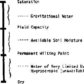
Figure 2-1 illustrates those
soil-moisture concepts.
Since irrigation is to provide water to the soil for plants to use, you should examine the soil. A typical soil can be looked upon as a three-phase system with approximately half the space occupied by solid material, one-fourth by gas, and one-fourth by liquid.
The solid phase consists largely of inorganic materials known as sand, silt, and clay that range from 2 mm to less than 0.002 mm in diameter. Sand particles are the largest (2.00 mm to 0.05 mm) and consist mainly of quartz. Sand has a gritty feeling when rubbed in the hand. Silt particles (0.05 mm to 0.002 mm) have a velvet-like feeling, while clay (less than 0.002 mm), the smallest size fraction, is sticky when moistened in the hand.
Most soils also have a small portion, 0.1 to 10 percent, of organic material which is extremely important because it increases water-holding capacity, improves structure, and provides plant nutrients as it decomposes.
Figure 2-2 illustrates a Soil Texture Triangle used in the United States. The triangle has been divided into regions such as "clay" or "sandy loam" depending upon the relative amounts of various sizes of soil particles present. To read the chart, the clay lines go horizontally to the right from the clay side of the triangle, the silt lines go down at a 45° slope from the silt side of the triangle, and the sand lines go up to the left at a 45° angle from the bottom (sand) side of the triangle.
The various size fractions of the soil are mixed into different combinations called soil textures. For example, a soil texture such as loam consists of 28 to 50 percent silt, 25-52 percent sand, and 7.5 to 27.4 percent clay. Soil containing equal amounts of the three separates is a clay loam.
The various textures indicated on the textural triangle (Figure 2-2) are generally grouped into three categories. Sands, loamy sands, and sandy loams are usually referred to as coarse-textured soils. Loams and silt loams are medium textured soils; while clay loams, silty-clay loams, and clays are known as finetextured soil. The fine-textured or clay soils are known as heavy soils, while coarse-textured soils are called light soils.
The terms heavy and light soils originated from the ease that tillage implements can be drawn through them. Thus, clays are difficult soils to draw implements through in contrast to sands whose tillage requires less power.
The relative proportions of soil particles by size can be shown easily by letting a sample of soil settle in water. Fill a fruit jar about two-thirds full of water. Pour in soil until the jar is almost full. Replace the cover or put one hand tightly over the top of the jar and shake it vigorously. Then put the jar on the table and let the soil settle (Figure 2-3). Allow plenty of time because the very small particles settle slowly.

Figure 2-2. The soil texture triangle
(from Handbook No. 436 U.S. Department of Agriculture, Washington, D.C., 1975)

Figure 2-3. Determining approximate
quantities of different sizes of soil particles
Then hold a card or heavy piece of paper against the side of the jar and draw a diagram showing the different layers. Label each layer (clay, silt, sand). Do this with several soils taken from different places and compare the diagrams or compare the jars directly. Soil particles vary greatly in size. The largest (sand) particles settle to the bottom first. The fine (clay) particles settle slowly; some, in fact, are suspended indefinitely.
Soil texture has a large influence on the amount of water it can store for plant use and the rate at which water moves through them (Tables 2-1 and 2-2. The coarse-textured soil can hold for plant use only 20 to 120 millimeters of water per meter depth of soil. At the other extreme, the fine-textured soil will hold from 140 to 200 millimeters per meter of soil. Familiarity with soil textures makes the irrigation design and operation easier and more efficient.
The root zone of plants depends upon the size of the plants. Most major field crops root about 1 to 1¼ meters deep. Most of the roots are nearer the surface, as shown in Figure 2-4. Most water below about 1 meter is essentially unavailable to plants.
Wilting points of most soils are from one-third to two-thirds of field capacity. Table 2-1 shows some typical ranges of available soil moisture to be expected with various soil textures. Irrigation in a typical soil would be required immediately when soil moisture declines to 50 percent of field capacity.
Table 2-1. Range of readily available soil moisture for different soil types
| |
Percent of moisture based on dry weight of soil |
||
|
Soil type |
Field capacity |
Permanent wilting point |
Available water per unit depth of soil, mm/m |
|
Fine sand |
3- 5 |
1- 3 |
20- 40 |
|
Sandy loam |
5-15 |
3- 8 |
40-110 |
|
Silt loam |
12-18 |
6-10 |
60-130 |
|
Clay loam |
15-30 |
7-16 |
100-180 |
|
Clay |
25-40 |
12-20 |
160-300 |
Adapted from: Booker, L. J., Surface Irrigation. FAO Agricultural Development Paper, No. 95, Rome, 1974.
Table 2-2. Long term infiltration rates for indicated soil types
|
Soil type |
Infiltration rate in mm per hour |
|
Clay |
1-5 |
|
Clay Loam |
5-10 |
|
Silt Loam |
10-20 |
|
Sandy Loam |
20-30 |
|
Sand |
Over 30 |
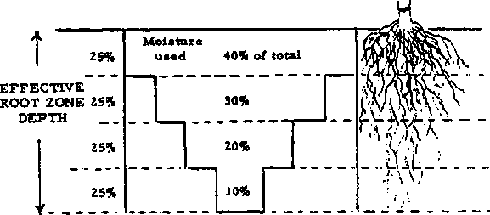
Figure 2-4. Moisture use in relation
to root zone and available moisture (S.C.S. Inf. Bull No. 199)
Most crops in deep, uniform soils use moisture more slowly from the lower root zone than from the upper soil. The top quarter is the first to be exhausted of available moisture. The plant then has to draw its moisture from the lower three-quarters of root depth. That stresses the plant because adequate moisture to sustain rapid growth cannot be extracted by the roots.
Soil structure is a term used to describe the arrangement of the soil particles Structure refers to a compounding or aggregation of soil particles into various forms such as platy, blocky, prismatic, etc. The moisture and air relationships of a soil are influenced by structure. An example of this is when soils containing some clay are trampled by animals while it is wet and the clay fills the pore space, thus creating a denser soil. Upon drying, such soil forms a massive structure and is said to be puddled when dry.
The density of soils is generally measured by two methods, "bulk density" and "particle density." Bulk density refers to the specific gravity of a volume of soil including its pore space. Thus, a cubic meter of soil including its pore space weighing 1,150 kg, divided by the weight of a cubic meter of water, 1,000 kg, has a bulk density of 1.15.
Particle density is a term used to measure the specific gravity of a soil excluding pore space. In other words, we are concerned with measuring the density of the soil particles without considering the air space between particles. Thus, if we assume that the soil just mentioned has a pore space of 48 percent, we can determine the particle density by dividing the weight of the soil particles (1,150 kg) by the weight of an equal volume of water (52 percent of 1,000 kg), 520 kg. The particle density will be 2.22 in this example. For any given soil, particle density will always be greater than bulk density. For most mineral soils, particle density averages about 2.65. Large portions of organic matter will tend to lower this figure. Bulk densities of soils will vary according to the texture and pore space. Bulk densities of coarse-textured soils usually range from 1.3 to 1.8, while fine-textured soils usually range from 1.0 to 1.3. Organic soils, depending upon the content of organic matter, usually range from 0.2 to 0.6.
To eliminate moisture contents as a variable, all calculations involved in determining particle density and bulk density are based on oven-dry weights of soil. Bulk density and particle density of a soil, if known, can be used to determine the "pore space" of a soil with this formula:
PS = 100 - (B.D./P.D. x 100)
where:
PS = pore space in percent
BD = bulk density
PD = particle
density
Substituting the previously determined figures for bulk density and particle density, gives us a pore space of:
PS = 100 - (1.15/2.22 x 100)
PS = 100 - 51.8
PS = 48.2
percent
The percentage of pore space in a soil is important because it determines the amount of water soil can hold when saturated.
Water is generally considered to be the universal solvent. The water molecule is dipolar, which means that one end of the molecule is negative in charge and the other is positive. Since opposite charges attract each other, this property permits the molecule to adjust to most materials.
Another property of water is relatively high surface tension. Surface tension is a measure of cohesion or attraction of water molecules to other water molecules. In contrast to cohesive forces, there are the adhesive forces. Adhesion is the attraction of water molecules to other molecules such as glass or soil.
Those soil properties, combined with various soil particle sizes, profoundly influence the movement, storage capacity, and retention of water in soil. Coarse-textured soils consisting of large particles tend to have fewer, but individually larger, diameter pores than fine-textured soils with small particles such as clay. A clay soil will have more total pore space, lower bulk density, and smaller diameter individual pores than a coarse-textured soil such as loamy sand.
Having a relatively high adhesive force, water is retained more in the fine-textured soils than in coarsertextured soils. This can be visualized by comparing the ease with which water can be poured through a two-inch diameter pipe to the difficulty of moving water through a capillary tube.
The relationship of water adhesion to soil particles can also be considered from the viewpoint of specific surface. Specific surface refers to the amount of surface area exposed to air or water. For example' a solid one-inch cube has a specific surface of six square inches. If the same cube is sliced in three places giving eight one-nalf inch cubes, the total surface will be twelve square inches, so a soil such as clay has a high specific surface and, consequently, a high percentage of the water adhering to the particles.
The rate that water will move into and through soils is important. Infiltration the rate surface water moves into soil. Percolation is the rate water above field capacity moves downward by gravity.
Infiltration is important because under natural rainfall, infiltration indicates how rapidly water will move into the soil. Low infiltration rates lead to more runoff and, frequently, to soil erosion.
Percolation rates must be high to sustain high infiltration rates. In many soils, layers of various-textured soils influence infiltration rates over long periods. For example, a clay layer beneath a sandy loam area results in a decreased infiltration rate when the sandy loam area becomes saturated.
In some cases, high infiltration rates are not desired. For example, ponds used to store irrigation water should have low infiltration rates. Rice paddies, where permanent flooding is desired, require less irrigation water when infiltration rates are low.
Fine-texture soils generally have lower infiltration rates than coarse-textured soils. The long-term infiltration rate refers to the millimeters of water that enters the soil per hour after a constant infiltration rate has been established. Some values are shown in Table 2-2.
The infiltration rate of a soil, an important factor when designing an irrigation system, may be measured in several ways. Unless large amounts of water are available, the methods are only approximate because if a small surface area is wetted, water will move vertically and laterally. Hence use as large an area as possible when measuring infiltration to minimize the effects of lateral movement, which might not occur during normal rainfall or irrigation conditions.
A measurement technique is to place a wall or dam around a level area to be tested, a 2 to 4 meter square area. Fill the small pond with water and keep the surface of the ground covered. After a length of time, one to a few hours, when ground appears to be well saturated near the surface, determine the rate of infiltration by measuring, usually with a bucket, the rate at which water must be added to keep the surface covered.
For one square meter of area, an infiltration rate of 1 liter per hour equals 1 millimeter (mm) per hour. If a stake is placed in the pond, the rate at which water goes down on the stake could be measured but the meniscus (the curvature of the water surface near a wall) makes this difficult to read.
As an example, a fence around an area is made of lumber enclosing an area of 4 m². After a constant infiltration rate is reached, 50 liters of water must be added to maintain the water level. The infiltration rate is then
50 liters/4 m² = 12.5 liters/hr m² or 12.5 mm/hr.