Back to Home
Page of CD3WD Project or Back to list of CD3WD Publications
 |  |  | Special Public Works Programmes - SPWP - Soil Conservation - Project Design and Implementation Using Labour Intensive Techniques (ILO - UNDP, 1982, 220 p.) |  |  | CHAPTER A. GENERAL PRINCIPLES | |  | A.1. THE DIFFERENT FORMS OF SOIL DEGRADATION | | | A.2. RAINFALL EROSION | | | 2.1. Factors in rainfall erosion | | | (introduction...) | | | 2.1.1. Rainfall | | | 2.1.2. Nature of the soil | | | 2.1.3. Slope of the land | | | 2.1.4. Vegetation | | | 2.1.5. Man | | | 2.2. The effects of rainfall erosion | | | 2.2.1. Mechanical effects | | | 2.2.2. Chemical effects | | | 2.3. Integration of rain water erosion factors | | | A.3. SOIL EROSION BY WIND | | | 3.1. Wind erosion factors | | | 3.2. The effects of wind erosion | | | A.4. OTHER FORMS OF SOIL DEGRADATION | | | 4.1. Excessive humidity | | | 4.2. Excess of toxic salts | | | 4.3. Unsuitable agricultural practices | | | 4.4. Socio-economic aspects of soil degradation | | | A.5. LAND USE | | | 5.1. Land employment | | | 5.2. Land classification | | | 5.2.1. Classification system developed by the Soil Conservation Service of the US Department of Agriculture | | | 5.2.2. Other classification systems |
|
Special Public Works Programmes - SPWP - Soil Conservation - Project Design and Implementation Using Labour Intensive Techniques (ILO - UNDP, 1982, 220 p.)
CHAPTER A. GENERAL PRINCIPLES
A.1. THE DIFFERENT FORMS OF SOIL DEGRADATION
Soil degradation may be due to rain run-off from the soil, the
effect of wind, excessive humidity, poor irrigation practice or unsuitable
farming techniques.
The most spectacular forms of soil degradation are due to
rainfall and wind which reshape the ground relief. Rain water running off over
the soil may carry away the main fertile components and even totally strip the
top soil which is the basis of agricultural production. The wind may have the
same effect by carrying away the fine particles of an unprotected soil,
including the main fertile components. The wind may also carry away larger
particles, depositing them at a distance and thus covering with sterile sand
deposits regions which were previously fertile.
Excessive humidity in the soil is another cause of degradation.
The sources of this humidity may be numerous and varied and due either to
topographical conditions (low-lying land), rivers overflowing into alluvial
plains, excessive rainfall or over-generous irrigation. The consequences are
degradation of soil structure and leaching of their chemical components,
defective soil aeration with resultant effects on cultivation, low yields or the
impossibility to continue agricultural production. Other forms of soil
degradation are more insidious, less spectacular but nevertheless just as
devastating for the region’s agricultural economy. In this case, it is the
soil’s chemical content that is degraded. These forms of degradation may be
due to excessive exploitation as the result of high demographic pressures. In
many countries, periods of fallowing which allowed the natural regeneration of
the soil have been reduced. The soil’s nutrients are not renewed and
fertilising is not sufficient. This degradation may also be the result of poor
irrigation in an arid climate where the salts brought in by irrigation build up
in the soil resulting in salination and alkalinisation. Thousands of hectares of
fertile land have been rendered unfit for cultivation in this
way.
A.2. RAINFALL EROSION
2.1. Factors in rainfall erosion
Atmospheric precipitation is the main cause of rainfall erosion
which produces surface run-off that has considerable destructive force. Other
factors affecting erosion are the nature of the soil, the slope, vegetation and
human
activity.
2.1.1. Rainfall
The main characteristics of precipitations are the amount of
rain, the intensity and the frequency. Rainfall intensity is one of the most
important factors in soil erosion. Rainfall erosivity is the result of the
kinetic energy in raindrops striking the soil; the amount of kinetic energy
increases with rainfall intensity; it leads to soil compaction and demolition of
aggregates.
Rainfall intensity is measured by means of a recording rain
gauge.1
1 Recordings in Madagascar have shown
that rainfall intensities of less than 1.5 mm/min are rarely erosive, whereas
rainfall intensities of over 2 mm/min are always erosive. The figure of 2 mm/min
is the cut-off point above which erosion occurs.
In Arkansas, USA, it is estimated that on uncovered, loamy soil
with a slight slope (6 per cent), erosion occurs as soon as the rainfall reaches
2.5 mm in 5 minutes.
The influence of rainfall intensity increases with increasing
soil humidity, i.e. with increasing rainfall frequency. A soil covered by a film
of water will disaggregate more readily and will have more intense rain water
run-off.
Annual precipitation variations also have an effect on soil loss
and years of heavier rainfall produce wash away larger quantities of
soil.
2.1.2. Nature of the soil
The susceptibility of soil to erosion depends on the soil’s
nature and is called erodibility.
Erodibility is difficult to assess since it depends on numerous
parameters, the most important of which are soil structure, texture, chemical
composition and organic-matter content.
Texture refers to the proportion of different size
particles in the soil. The smallest particles are clays and the largest are
stones or gravel.
The international system classifies soil texture as follows:
- clays with a particle size range less than 0.002
mm
- silts with a particle size range between 0.002 and 0.02 mm
- fine
sands with a particle size range between 0.02 and 0.2 mm
- coarse sands with
a particle size range between 0.2 and 2.0 mm
- gravels with a particle size
range greater than 2.0 mm
Structure refers to the arrangement of these individual
particles in the soil into separate aggregates of different size and shape.
The cohesion of the structure or “structural
stability” can be determined by use of H�nin’s
“instability index”, the factors of which are:
- the mean percentage of stable aggregates,
- the
fraction of dispersed clay plus loam,
- the fraction of coarse
sand.
It is expressed by the equation
Structural stability is an important factor in water run-off and
erosion. Stability is due in particular to humic and clayey colloids of soil
which hold together sand and alluvial particles. The chemical nature of the
bases which are linked to the absorbant complex also plays a role in the
structural stability.1
1 Calcium and magnesium ions allow
flocculation and, consequently, greater stability; sodium ions cause dispersion
and structural disaggregation.
Disaggregation of the structure results in reduced soil
permeability and
porosity.
2.1.3. Slope of the land
The speed of rainfall run-off on soil increases with increasing
slope, and soil erosion increases with increasing run-off speed.
Run-off flow rate and the amount of particles carried away also
vary in relation to the length of the slope.
With a given angle of slope, erosion intensity will depend on:
- the nature of the soil
- vegetation cover
-
precipitation
Intensity
2.1.4. Vegetation
This is a major factor in controlling soil degradation and acts
in several ways:
- By protecting the soil from the direct impact of
water drops. When rain water is intercepted by the plant covering before it
reaches the soil, the height of its fall is reduced and, consequently, its
kinetic energy and destructive effect are smaller.
- By intercepting some of the rainwater which then remains on
the foliage and evaporates without increasing the ground run-off volume.
- By inhibiting ground water run-off due to the matting of roots
and accumulated vegetable matter.
- By enriching the soil with organic material which improves
structure and porosity.
Roots and, in particular, the matting of fine roots increase the
cohesion of soil particles. Their effect is even greater if they grow densely
close to the surface. Dead roots increase the porosity of the soil surface and
promote water infiltration. Organic matter resulting from leaf decomposition
improves soil structure.
The effects vary depending on the type of vegetation.
Forest growth has the greatest effect in protecting soil from
water erosion. Forest soil contains 2 to 3 per cent of organic material.
A grass covering may also have a significant effect provided the
plant coverage is dense.
Fallowing also plays a conserving role depending on the type of
vegetation involved (forest fallowing, crop fallowing, bare fallowing).
Crops have a less conservational effect. Resistance to erosion
increases with increased density of crops. Forage pasture offers better
protection than cereals or hoed crops.
Orchards do not constitute a sufficiently dense vegetation to
effectively control erosion.
Research carried out around Lake Aloatra, Madagascar (ref. 1),
on the Aristida pastures with slopes of 20 to 36 per cent have shown the
following topsoil losses in relation to the density of vegetation coverage:
|
- 100 per cent covered soil |
0.026 t/ha/year |
|
- 40 to 60 per cent covered soil |
4 t/ha/year |
|
- 20 per cent covered soil |
12 t/ha/year |
2.1.5. Man
Man is a prime factor in soil degradation since irrational use
of the soil is often at the origin of erosion.
Abusive use of forests and pastures may lead to their
destruction; the same applies to abusive clearing of the soil on very steep
slopes, unsuitable crops, ignorance of the mechanisms by which organic material
is lost from the soil and how it is
replaced.
2.2. The effects of rainfall erosion
2.2.1. Mechanical effects
These are due to the impact of water droplets on the soil and
the erosive force of rain water run-off. Primary or “splash” erosion
is due to the impact of the raindrop on the soil which breaks up the soil
particles and may project them up to 60 cm vertically and 1.50 cm horizontally.
The energy released by soil particle disaggregation increases with rain
intensity.
The finer soil particles are more readily dispersed by the
“splash” effect. These particles block the pores in the soil surface
decreasing the soil absorption capacity, and the excess water runs off carrying
away the fine particles in suspension.
“Splash” erosion can be reduced or prevented by a
covering of vegetation which absorbs a large part of the raindrop’s kinetic
energy.
Water which does not filter through the soil on a watershed runs
down the slope. Initially, the run-off is diffuse or forms a sheet of water in
minute anastomosing streams. Gradually, these streams hollow out small grooves a
few centimetres in width and depth which may carry away fine components up to
sand particles of 0.2 mm diameter. This type of erosion may progressively strip
the top and most fertile layers of the soil. Cultivation and biological
practices may reduce this erosion by modifying soil stability or aggregate size.
If such processes are not adequate, mechanical processes may be employed by
levelling the land, breaking it down into small fields in which erosion is no
longer a danger.
As erosion continues, run-off collects in small rills or
channels where its erosive and transporting powers are enormously increased. The
rills become gullies and the gullies become progressively deeper and wider
forming ravines. If the process is allowed to continue all the top soil may be
stripped off.
Where rill or gully erosion takes place, cultivation or
biological processes are no longer sufficient to retain the soil. Dividing the
land into small fields significantly reduces rill erosion; however, when gully
erosion occurs, more extensive collective measures are required. The erosion
sediment is carried by gullies, streams and rivers to lakes, dams or, finally,
to the sea. Local deposition of sediment can cause great damage to growing crops
and silt up drainage and irrigation channels, increasing the danger of flooding.
The end result of uncontrolled water erosion is the loss of soil
and destruction of its productive capacity.1
1 To give an example of the proportions
that this type of erosion can attain, it is estimated that in India, with a
total surface area of 3.3 million km2, 1.4 million km2 are
subject to significant soil loss and 6,000 million tonnes of soil are lost each
year from a surface area of only 800,000 km2 (UNESCO Courrier, May
1980).
2.2.2. Chemical effects
Added to soil loss, there are significant losses of fertile
components,2 in particular mineral salts. Drainage water may contain
up to 50 g of calcium nitrate in the case of cultivated land and up to 150 g in
the case of bare land.
2 In India, it is estimated that 6
million tonnes of fertile components disappear each year, i.e. more than is
applied in the form of fertiliser.
A rainfall of 10 mm on a soaked soil may carry off 5-15 kg of
this fertiliser per
hectare.
2.3. Integration of rain water erosion factors
An attempt at an integration study of rain water erosion factors
is given in Wischmeier’s formula.

Fig. A.1: Diagram of the
main natural factors in run-off erosion
After M. Deloye and H. Rebour 1953 (ref.
11)
This formula, when applied to a specific region, makes it
possible to estimate soil loss and determine what erosion control methods should
be implemented to ensure that erosion does not exceed the threshold at which it
becomes dangerous.
Wischmeier’s formula is as follows:
Where:
A is the soil loss in tonnes per acre1 (1
American short ton = 0.907 kg);
1 1 acre is equal to
approximately 4,000 m2.
R is the precipitation erosivity factor or
“rain index”.
It can be calculated for a rainfall or for the rainfalls over a
given period. Generally, a mean annual rainfall index is used.
For a given rainfall:

|
where |
Eg = kinetic energy of the rain in feet/tonne/year; |
|
Im = maximum Intensity of the rain in 30 min in inches/hour.
|
To calculate the kinetic energy of rain, it is necessary to have
a hyetogram recording in which the rain is broken down into segments of equal
intensity in order to establish a duration-intensity ratio.
The relationship between kinetic energy of a rainfall (of
regular intensity) am intensity is given by the formula:
Eu = 916 + 331 Log Ih
In which:
Eu = unit kinetic energy in
feet/ton/year
Ih = intensity in mm/h
The energy in segment Eh is equal to Eu multiplied by
the number of millimetres which have fallen during the segment. The energy is
cumulative.

In order to calculate Im, it is necessary to mark on the
recording the 30 min section of the curve in which the largest number of
millimetres of rain fell.
K or the “soil index” is a dimensionless factor which
measures the relative resistance of a soil to erosion. These values are obtained
experimentally.
L.S or the “slope index” is a dimensionless factor; it
indicates the effect of the angle and length of the slope (see fig. A.2).
C or the “cultivation index” is the ratio of earth
loss of cultivated land under well-defined conditions to that of a continually
worked fallow land where C = 1 (fig. A.3).
P or the “water and soil conservation index” is the
ratio of earth loss on a field in which soil conservation is practised to that
of a cultivated field along the line of maximum slope (fig. A.4).

Fig. A.2: Wischmeier’s
universal equation (graph giving the values of the factor L.S as a function of
the length and percentage of the slope (ref. 23))
Fig. A.3: Crop coefficient values - C
|
Type of crop |
C |
|
In the United States |
|
non-hoed crops (rice-cereals) |
0.6-0.8 |
|
plant covering, green manure |
0.3-0.6 |
|
fallow and depending on the condition, location, climate |
0.3-(1.5) |
|
In Tunisia: |
|
bare earth - bare fallow land |
1 |
|
orchards |
0.90 |
|
wheat |
0.71 |
|
rotation with cereals |
0.40 |
|
fodder |
0.47 |
|
rotation with fodder |
0.15-0.23 |
|
improved pastures |
0.01 |
For mechanised cultivation, these values should be subjected to
a coefficient of 1.3-1.8.
Fig. A.4: Erosion reduction coefficient of soil
conservation remedies
|
Value of P factor: water and soil conservation index in
% |
|
|
|
Terraces |
|
Slope % |
Contour line cultivation L value to be considered: length of
field slope |
Rotational field strip cropping value of L to be considered:
length of field slope |
the earth in the channel is considered lost Value of L to be
considered: distance between channels |
the earth in the channel is not considered lost Value of L to be
considered: distance between channels |
|
1.1 - 2.0 |
60 |
30 |
60 |
30 |
|
2.1 - 7.0 |
50 |
25 |
50 |
25 |
|
7.1 - 12.0 |
60 |
30 |
60 |
30 |
|
12.1 - 18.0 |
80 |
40 |
80 |
40 |
|
18.1 - 24.0 |
90 |
45 |
90 |
45 |
A.3. SOIL EROSION BY WIND
3.1. Wind erosion factors
The erosive effect of wind varies depending on the nature of the
vegetation and soil.
The ability of wind to move soil particles depends on wind
intensity and particle size. At soil level, wind speed is zero, flow is laminar
for a height of a few millimetres and thereafter wind speed increases as the
distance from the soil increases as a function of the logarithm of height.
It is estimated that the wind speed required to move the finest
soil particles is 15 km/h. The effect of wind varies depending on particle size.
The smallest particles are carried in suspension in air and may
form dust storms that move over considerable distances.
Medium-size particles of 0.05-5 mm diameter are carried in a
bouncing action over the surface of the ground by a phenomenon called
saltation.
The larger particles roll or “creep” along the
surface. The saltation effect increases the number of particles in motion as
they are carried along; this has an avalanche effect. The amplitude of the
phenomenon increases the greater the area of land exposed to the wind.
Vegetation is the best protection against wind since it breaks
the force of the wind and reduces the area of exposed land, thus limiting the
saltation process.
The soils most susceptible to wind erosion are those of coarse
texture and, in particular, fine sands. The soil’s level of humidity also
plays a role and dry soils offer the lowest resistance to the effect of the
wind.
Wind erosion occurs, in particular, in arid and semi-arid
regions in which there is a major dry period and light vegetation - part of
which disappears totally during the dry season due to over grazing of pastures.
The constant action of cattle hooves tends to break up the soil surface and make
it more susceptible to wind erosion.
In temperate climates, wind erosion is also encountered on sandy
coastal areas due to the soil texture and the absence of sufficiently dense
vegetation.
Crops and various farming techniques can also cause erosion.
Repeated working of the soil and excessive soil fragmentation during the dry
season tend to increase the danger of erosion whereas cultivation techniques
which maintain or increase soil surface roughness (ploughing, banking) have a
protective
effect.
3.2. The effects of wind erosion
Wind erosion has a deleterious effect on the soil:
- by loss of fine soil components, and fertile
components in particular, which leads to structural degradation and a reduction
in water retention capacity;
- by moving the coarser components which build up behind various
obstacles and form dunes which can cover and make sterile entire
regions.
Wind erosion also effects vegetation itself. Windborne sand
particles have an abrasive effect on grass and crops. The wind increases
vaporisation and tends to exhaust the soil’s usable water content more
rapidly.
A.4. OTHER FORMS OF SOIL DEGRADATION
4.1. Excessive humidity
Excessive humidity in the soil leads to degradation and reduced
fertility. Water is an essential component for soil and plant life but excessive
quantities have disadvantages due to:
- reduction of chemical and bio-chemical action
resulting from oxygen deficiency which prevents oxidation and certain
micro-organism life;
- the reduction of soil temperature as a result of excessive
surface evaporation;
- its action on plant roots which can no longer penetrate deeply
into the soil and which often suffer from parasitic disease promoted by the high
humidity;
- the difficulty of cultivating wet soil;
- reduction in crop yield may range from a slight fall to total
crop loss.
Excessive humidity can be controlled by
drainage.
4.2. Excess of toxic salts
In arid and semi-arid climates, irrigation may lead to the build
up of toxic salts in the soil. Each new irrigation flow brings with it a certain
quantity of mineral salts. If the water flow is not sufficient to leach the
soil, i.e. take the salts down to lower levels where they will not be harmful to
plant life, these salts gradually build up in the soil due to vaporisation until
they reach concentrations harmful to crops.
In addition to salt concentration (Salinisation), the phenomenon
of alkalinisation may occur, i.e. calcium ions are replaced by sodium ions in
the absorbant soil components and this leads to degradation of soil structure
and reduced permeability.
These phenomena can be controlled by leaching the soil and by
suitable draining to evacuate water with a high dissolved-salt
content.
4.3. Unsuitable agricultural practices
Intensive agriculture and failure to apply adequate amounts of
fertilisers exhaust the soil of its plant nutrients. This form of soil
degradation1 is noted only in passing since measures for remedying
this do not come within the framework of labour-intensive work.
1 There are other forms of degradation
such as sedimentation or soil
acidification,
4.4. Socio-economic aspects of soil degradation
The main effect of soil degradation is the damage to
agricultural activities that result. The harm to agricultural land may be
irreversible, or the cost of returning the land to its fertile state may be so
high as to be not economically viable.
The farmer’s profits must be sufficient to allow him to
live and pay other expenses such as fertilisers, seeds, fuel, etc. They must
also be sufficient to invest in soil conservation and improvement.
This situation is of course more difficult to achieve in
smallholdings with poor soils than on largeholdings with good soils.
As erosion progresses, the farmer’s work becomes more
difficult, more expensive and less profitable and finishes by becoming
impossible. At the regional level, the deleterious effects finally undermined
the total structure of social and economic life.
In order to avoid such situations it becomes necessary, wherever
possible, to encourage conservation measures which bring together the largest
number of farmers in work of value to the
collectivity.
A.5. LAND USE
5.1. Land employment
Depending on its characteristics, land is normally classified
into two large categories: production land and protection land.
Production land is used for cultivation.
Protection land usually has natural forest or pasture vegetation
and plays a major role in the conservation of the cultivated land that is
situated downhill.
The balance between production and protection land will vary
depending on the country’s level of development and may change depending on
technical, social and economic conditions.
Although protection land is of less significance from the
economic point of view than production land, it has a decisive role in
maintaining the country’s biological
balance.
5.2. Land classification
5.2.1. Classification system developed by the Soil Conservation Service of the US Department of Agriculture
The classification is divided into:
- capability units;
- capability subclasses;
-
capability classes; see fig. A.3, crop coefficient values.
The capability units group soils that have about the same
influence on crop production and respond in about the same way to the management
requirements of common crops.
The subclasses group capability units having similar limitations
(erosion hazard, wetness and climatic limitations).
The capability classes describe progressively, in eight stages,
the degree of risk to erosion and limitations of use.
The simplified classification is as follows:
Simplified classification
|
Unit |
Subclass |
Class |
|
|
I |
|
|
Land suitable for cultivation |
|
1 |
|
Land with annual cultivation |
|
|
I |
Land that can be permanently cultivated and which, when normally
rotated, is treated with fertiliser or lime. These are lowlands for which
conservation practices are not necessary. |
|
|
II |
Less fertile land with lower yield, often on a slight slope
(3%), where erosion has already taken place by reducing the depth of the arable
land. Moderate conservation practices necessary. |
|
2 |
|
Land with intermittent cultivation |
|
|
III |
The soil has to be reconstituted periodically by allowing a
vegetation covering to occur, and cultivation takes place only from time to
time. This is the case of eroded land with slopes of 10-16%. |
|
|
IV |
Land where the slope is steeper than in class III and more
seriously eroded. Is suitable only for occasional or limited cultivation. |
|
II |
|
|
Land requiring permanent cover |
|
|
V |
Land not suitable for ploughing but relatively resistant to
erosion. Suitable for permanent pasture. Requires careful exploitation. |
|
|
VI |
Land of the above type but which has poor erosion resistance due
to physical properties or topography. It can be used for pasture with
conservation techniques required from time to time. |
|
|
VII |
Exhausted land. Pronounced erosion that can be reconstituted by
grassing or planting with total conservation practices. |
|
III |
|
|
Non-productive land |
|
|
VIII |
Soils of class VIII are suitable only for natural vegetation,
forests, etc. Should not be cleared. |

Fig. A.5: Land
classification on the basis of susceptibility to run-off erosion (based on a
drawing published in the USA)
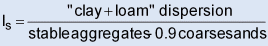
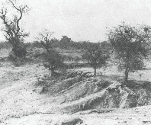
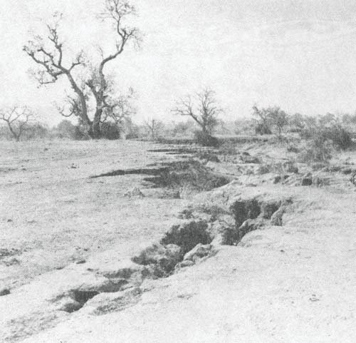
Fig. A.6: Deep gully. Advanced stage of erosion
(Upper Volta)
Figure
Figure
Examples of advanced stage of erosion
Niger
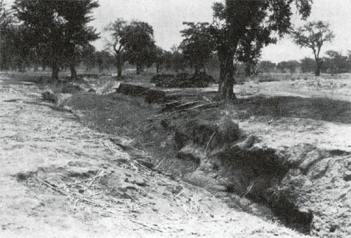
Upper Volta

Upper
Volta
5.2.2. Other classification systems
|
5.2.2.1. |
Classification by degree of run-off erosion (ref. 11), see fig.
A.7. |
|
|
|
5.2.2.2. |
Classification of land by slope in tropical Africa (ref. 1), see
fig. A.8. |
|
|
|
5.2.2.3. |
The classification of BEEK and BENNEMA (FAO 1972) (ref. 28).
This is a new classification system designed more specifically for developing
countries. It incorporates social and economic factors into the technical
capability classification. |
Fig. A.7: Diagramatic classification of degrees of
run-off erosion
|
Current or potential state |
Apparent effects of erosion |
Soil characteristics |
Types of remedy |
|
I. Stage of stability |
Insignificant, clear run-off water. No apparent erosion |
Flat or almost flat land or very slight slopes less than 3% High
permeability: 20 cm/hour (cf. 3.2.4, Ch. D)
Dense cover of vegetation
Good
fertility
Good soil cohesion
Land well supplied with humus |
All types of crop possible
No treatments |
|
II. Stage of insidious erosion |
Slight run-off of turbid water at very low speed during heavy
precipitations
No apparent erosion or traces of rills |
Slight uniform slopes of less than 3%, or very intersected
slopes of 5-8%
Good permeability: 12-15 cm/hour
Light covering of
vegetation
Moderate fertility
Relatively good soil cohesion
Land with a
relatively good humus content |
All crops on contour lines
Well planned rotation
From time
to time, bench terraces
Reduced grazing density |
|
III. Stage of initial apparent erosion |
Run-off already quite pronounced with moderate precipitation;
muddy water flowing at moderate speed
Appearance of light patches and stones
on surface
Shallow gullies appear especially after the soil has been broken
up, but do not hinder machines
Slight reduction in fertility |
Uniform slopes of 5-8%, or intersected slopes of 10-16%
Small
collection basins (1 or 2 hectares)
Moderate permeability: 8-10
cm/hour
Very slight cover of vegetation
Moderate fertility
Poorly
coherent soils
Land with only slight humus content |
Alternating crops on contour lines with ½ in annual cover
crops
Bench terraces often necessary
Reduced grazing density |
|
IV. Stage of intense erosion |
Heavy run-off of muddy water with moderate and heavy
precipitation, speed quite high to very high
Increase in the number of
patches and stones Deep gullies which begin to Impair mechanical cultivation
|
Uniform slopes of 10-16% or intersected slopes of
20-30%
Watershed of several hectares
Low permeability: 2-5 cm/hour
No
vegetation covering |
Alternating permanent grass and cereal cultivation, for example
cover crops must dominate in the rotation system
Terracing
essential
Back-sloping terracing necessary on slopes over 15%
Ploughed
crops are possible between terraces
Low grazing density |
|
V. Stage of dangerous erosion |
Pronounced run-off at the slightest rainfall Water carries
gravel or aggregates moving at high speed in the event of heavy
precipitation
Deep gullies preventing the movement of heavy machines
Land
carried away in blocks |
Uniform slopes of 20-30% or intersected slopes of
45-65%
Large watershed
Very low permeability 0.5-1 cm/hour
No
vegetation cover
Mediocre fertility
Unstable soils |
“Algerian terraces” essential
Cover cultivation
everywhere, with permanent grass cover on large surfaces
Pasture, woods very
light grazing density with periodic prohibition |
|
VI. Final stage of erosion |
Top soil entirely stripped away |
Very steep slopes
Very large watersheds
Virtually zero
permeability
No vegetation cover
Fertility completely lost
Unstable
soils |
Diversion channel above and below to protect cultivated
areas
Prohibition of grazing
Trial tree-planting on back-sloping terraces
|
Observations
|
1st column: |
A given area of land may go successively through the six stages
described, commencing with the stage of stability. |
|
|
|
2nd column: |
There is a constant danger that the features may deteriorate,
but they can regress if the treatment given in column 4 is suitably applied.
Where the proposed remedies prove Inadequate, it would be necessary to
immediately apply the remedies of the next, more serious stage. |
|
|
|
3rd column: |
This is merely a list of different features, some of which must
exist in combination; however, it is not necessary that all be present. |
|
|
|
4th column: |
For each category, there is listed a number of treatments by
order of effectiveness; the choice should be made depending on the stage to
which the erosion has progressed. Obviously, general remedies (working,
fertiliser, etc.) should be applied at all stages. Various stages may coexist in
a single plot of land. In general, the erosion starts at the lowest part
(watershed effect) and moves progressively upwards. |
Fig. A.8: Classification of land on the basis of slope
(in tropical Africa)
Reference 1
|
Slope
% |
Land use |
Possible cultivation methods |
Crops to be avoided |
Protective measures |
|
0-3 |
Various crops |
Mechanised cultivation |
- |
- |
|
3-12 |
Crops alternating with grass cover |
Mechanised cultivation |
Precautions to be taken for bush-type culture on bare soil |
Absorption or diversion network
Contour cultivation |
|
12-25 |
Crops grassland woodland |
Manual cultivation
Animal-drawn machines |
Bush-type crops on bare soil |
Anti-erosion networks
Terraces |
|
25 |
Pasture forestland |
Manual cultivation |
All |
Anti-erosion ditches |